
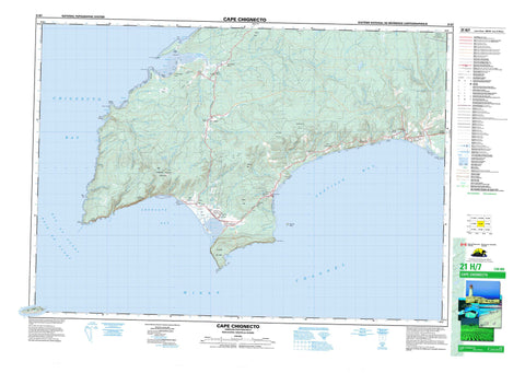
021H07 Cape Chignecto Canada topo map, 1:50,000 scale
021H07 Cape Chignecto NRCAN topographic map.
Includes UTM and GPS geographic coordinates (latitude and longitude). This 50k scale map is suitable for hiking, camping, and exploring, or you could frame it as a wall map.
Printed on-demand using high resolution, on heavy weight and acid free paper, or as an upgrade on a variety of synthetic materials.
Topos available on paper, Waterproof, Poly, or Tyvek. Usually shipping rolled, unless combined with other folded maps in one order.
- Product Number: NRCAN-021H07
- Parent Topo: TOPO-021H
- Map ID also known as: 021H07, 21H7, 21H07
- Unfolded Size: Approximately 26" high by 36" wide
- Weight (paper map): ca. 55 grams
- Map Type: POD NRCAN Topographic Map
- Map Scale: 1:50,000
- Geographical region: Nova Scotia, Canada
Neighboring Maps:
All neighboring Canadian topo maps are available for sale online at 1:50,000 scale.
Purchase the smaller scale map covering this area: Topo-021H
Spatial coverage:
Topo map sheet 021H07 Cape Chignecto covers the following places:
- Advocate Bay - Advocate Harbour - Andersons Cove - Apple River Bay - Baie de Fundy - Bay of Fundy - Bay of Fundy - Broad Cove - Carrying Cove - Chignecto Bay - Devils Slide Cove - Greville Bay - Horseshoe Cove - Lubber Hole - Minas Basin - Refugee Cove - Scots Bay - Seal Cove - Spicer Cove - Spicers Cove - Big Beach - Edgetts Beach - Polly Flats - Pollys Flats - The Bar - West Beach - Apple Head - Boars Head - Cap d'Or - Cape Capstan - Cape Chignecto - Cape d'Or - Cape D'Or - Cape Spencer - Fowler Head - Fox Point - Green Point - Halibut Head - Pudsey Point - Squally Point - Minas Channel - Cumberland - Ile Haute - Isle Haute - Spencer Island - Spencers Island - Beaverdam Lake - Shulie Lake - Allen Hill - Beech Hill - Bennett Hill - Birch Hill - Fields Hill - French Lookout - New Yarmouth Mountain - Turple Hill - Watering Brook Hill - Woods Mountain - Cumberland - Chignecto Game Sanctuary - Jardine Plains - Apple River - Apple River - Arch Brook - Back Channel - Baldrock Brook - Barn Camp Brook - Barren Brook - Bear Creek - Big Bald Rock Brook - Birch Cove Brook - Bog Brook - Brown Dugway Brook - Brown Hollow Brook - Brown Hollow Brook - Burke Brook - Carey Brook - Clark Hollow Brook - Coldspring Brook - Copp Hollow Brook - Dewis Brook - Dewolf Brook - Dow Brook - Dows Brook - Dry Hollow Brook - East Apple River - East Branch Apple River - Eatonville Brook - Elliott Brook - Finney Brook - Fowler Brook - Fowler Brook - Fox River - George Fraser Brook - Grant Brook - Greville River - Henning Brook - Hollow Brook - Indian Brook - Jardine Brook - Kelley River - Kelley River (Mill Creek) - Kelly River - Keyhole Brook - Killam Brook - Little Bald Rock Brook - Little Baldrock Brook - MacKay Brook - Mahoney Brook - Marsh Creek - McCully Brook - McGahey Brook - McRitchie Brook - Melton Brook - Mill Brook - Mill Creek - Mill Creek - Morang Branch Apple River - Morang River - Ninemile Brook - North Mill Creek - Northeast Branch McRitchie Brook - Northeast McRitchie Brook - Northwest Fox River - Nuttall Brook - Otter Brook - Paint Mine Brook - Phinney Brook - Quinn Brook - Rapid Brook - Red River - Refugee Cove Brook - Sand River - Seal Brook - Seal Cove Brook - Ship Timber Brook - Shulie River - Smith Brook - Soldier Brook - South Apple River - South Apple River - South Branch Apple River - Spicer Brook - Spicer Cove Brook - Spicers Cove Brook - Spring Brook - Upper Seal Brook - Ward Brook - Wards Brook - Warmspring Brook - Watering Brook - West Branch Red River - West Greville River - Bald Rock - Dudgen Rock - Field Rocks - Fields Rocks - Narrows Reef - Red Rocks - Three Sisters - Advocate Harbour - Allen Hill - Apple River - Brookville - East Advocate - East Apple River - East Fraserville - Eatonville - Fox River - Fraserville - New Salem - New Yarmouth - North Greville - Parrsboro Shore - Parrsborough Shore - Point Hill - Port Greville - Red River - Spencers Island - Wards Brook - West Advocate - West Apple River - Arch Gulch - Diamond Gulch - Advocate Dyke Marsh - Apple River Bog - Big Bog - Big Bog - Little Bog - Polly Bog - Pollys Bog


