
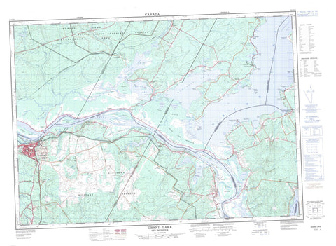
021G16 Grand Lake Canada topo map, 1:50,000 scale
021G16 Grand Lake NRCAN topographic map.
Includes UTM and GPS geographic coordinates (latitude and longitude). This 50k scale map is suitable for hiking, camping, and exploring, or you could frame it as a wall map.
Printed on-demand using high resolution, on heavy weight and acid free paper, or as an upgrade on a variety of synthetic materials.
Topos available on paper, Waterproof, Poly, or Tyvek. Usually shipping rolled, unless combined with other folded maps in one order.
- Product Number: NRCAN-021G16
- Parent Topo: TOPO-021G
- Map ID also known as: 021G16, 21G16
- Unfolded Size: Approximately 26" high by 36" wide
- Weight (paper map): ca. 55 grams
- Map Type: POD NRCAN Topographic Map
- Map Scale: 1:50,000
- Geographical region: New Brunswick, Canada
Neighboring Maps:
All neighboring Canadian topo maps are available for sale online at 1:50,000 scale.
Purchase the smaller scale map covering this area: Topo-021G
Spatial coverage:
Topo map sheet 021G16 Grand Lake covers the following places:
- Allens Cove - Back Lake - Big Cove - Brownhouse Lead - Bull Paddy Cove - Coldspring Lead - Coy Cove - Cumberland Bay - Days Cove - Douglas Harbour - Dykeman Cove - Estabrooks Cove - Gilchrist Cove - Hunters Ferry Cove - Mill Cove - Mill Cove - Palmer Lead - Podnocker Cove - Rouses Cove - Sand Cove - Sypher Cove - The Dugway - Turneys Cove - White Cove - Whites Cove - Wiggins Cove - Youngs Cove - Grand Point Bar - Ox Island Bar - Sunnyside Beach - Balmain Point - Balmain Point (Indian Point) - Branscombe Point - Bridges Point - Cow Point - Cumberland Point - Denton Point - Deveber Point - Dingee Point - Fanjoy Point - Fanjoys Point - Ferris Point - Grand Point - Grassy Point - Grimross Neck - Indian Point - Nash Point - Oak Point - Palmer Point - Pops Point - Robertson Point - SandPoint - Scovil Point - Simmons Point - Stickney Point - Taylor Point - Wiggins Point - Blind Thoroughfare - Coys Gut - Duck Creek - Gagetown Creek - Lawson Passage - Lower Thoroughfare - Main Thoroughfare - Ox Island Channel - Raft Channel - Sheffield Channel - The Blobs - The Narrows - The Thoroughfare - Upper Thoroughfare - Burton - Cambridge - Canning - Gagetown - Hampstead - Lincoln - Maugerville - Queens - Sheffield - Sunbury - Waterborough - Wickham - Oromocto 26 - Apple Island - Coreys Island - French Island - Fulton Island - Gagetown Island - Gilbert (Mauger's) Island - Gilbert Island - Grimross Island - Gull Island - Harrison Island - Huestis Island - Hunters Island - Indian Island - Marshalls Island - McAllisters Island - Middle Island - Nevers Island - Oak Island - Oromocto Island - Ox Island - Princes Island - Ram Island - Ram Island - Reach Island - Ring Island - Thatch Island - Thatch Island - Upper Musquash Island - Walkers Island - Back Snowshoe Lake - Ballantyne Pond - Chain Lakes - Clarks Pond - Cowperthwaite Lake - Coy Lake - Coys Lake - Denton Pond - Duffie Lake - Dykeman Lake - Estabrooks Pond - First Snowshoe Lake - Foshay Lake - French Lake - Grand Lake - Hart Lake - Harts Lake - Indian Lake - Little Lake - Lower Timber Lake - Maquapit Lake - Morgan Lake - Rush Lake - Swan Creek Lake - Swan Lake - The Keyhole - Thorne Pond - Upper Timber Lake - Washademoak Lake - Gunters Wharf - Base des Forces canadiennes Gagetown - Canadian Forces Base Gagetown - Champ de tir et champ de manoeuvre Gagetown - Gagetown Range and Training Area - Cherry Hill - Den Hill - Maple Rim - Oak Point Ridge - Grand Lake Provincial Park - Lakeside Provincial Park - Maison de Sir Leonard Tilley - Portobello Creek National Wildlife Area - Réserve nationale de faune de Portobello Creek - Sir Leonard Tilley House - Allen Brook - Back Field Brook - Bailey Brook - Bailey Brook - Baltimore Creek - Baltimore Stream - Bartlett Millstream - Beartrap Brook - Beaver Brook - Birch Brook - Birch Brook - Black Brook - Brown Brook - Brownhouse Brook - Bull Pasture Brook - Burpee Brook - Burpee Mill Stream - Burpee Millstream - Buskirks Brook - Coldspring Brook - Cow Pasture Brook - Den Brook - Dingee Mill Brook - Dingee Mill Stream - Dingee Millstream - Dykeman Brook - East Branch Baltimore Stream - Estey Creek - Falls Brook - Farnham Brook - Farnham Brook - Fergusons Brook - Flowers Brook - Full Mill Brook - Geary Brook - Gilchrist Brook - Glass Brook - Grimross Canal - Hayden Brook - Hobens Brook - Huestis Creek - Irvine Brook - Jemseg River - Kenney Creek - Kenny Brook - Keyhole Brook - Kinney Creek - Knight Brook - Lindsay Brook - Little Burpee Brook - Little River - Little Swan Creek - Loders Creek - McAlpines Brook - McGarrigle Brook - McMonagles Brook - Morton Brook - Mount Creek - Noonan Stream - Northwest Branch Noonan Stream - Old House Brook - Oromocto River - Otter Creek - Peter Brook - Pond Stream Brook - Portobello Creek - Portobello Stream - Red Pine Brook - River Styx - Rivière Saint-Jean - Rockwell Stream - Rouses Brook - Saint John River - Saunders Brook - Sawmill Brook - Snake Creek - Streets Brook - Streets Brook - Streets Creek - Sucker Brook - Swan Creek - Tantawanta Brook - Tantawanta Stream - Taylors Brook - The Ditch - Thorne Brook - Thorne Pond Brook - Tracy Brook - Trout Creek - Tyng Brook - Vandine Brook - West Branch Baltimore Stream - Weston Brook - Weston Brook - Wrights Brook - Portobello Reach - The Oxbow - Dykeman Shoals - Oromocto Shoals - Purdy Shoal - Purdy Shoals - Street Bar - Oromocto - Babbitt - Burpees Corner - Burton - Burton - Camp Gagetown - Camp Gagetown Project - Cherry Hill - Clarks Corners - Coy Town - Coytown - Douglas Harbour - Farnham Settlement - Fernmount - Fernmount Station - Geary - Goan - Greenfield Settlement - Gunter - Gunters - Hall - Haneytown - Hersey Corner - Jemseg - Lakeville - Lakeville Corner - Lauvina - Lower Burton - Lower Jemseg - Maquapit Lake - Maugerville - McDonald Corner - McGowans Corner - Mill Cove - Mill Road - Princess Park - Randall Corner - Ripples - Scotchtown - Scovil - Sheffield - Shirley Settlement - Swan Creek - Upper Gagetown - Waterborough - White Cove - Whites Cove - Ash Swamp - Babbitt Marsh - Babbitts Meadows - Beaver Heath - Boyds Marsh - Broad Meadows - Bush Meadow - Dingee Marsh - Earles Meadows - Grand Lake Meadows - Interval - Jemseg Flats - Kenny Meadows - The Intervale - Gagetown


