
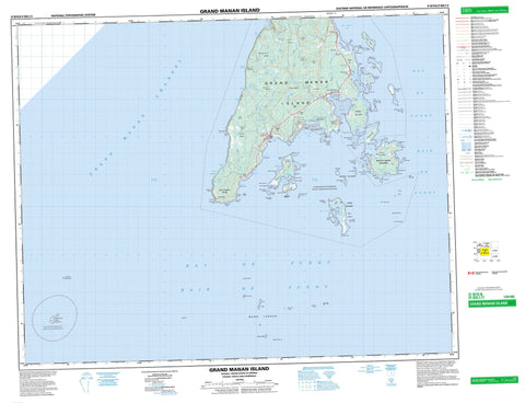
021B10 Grand Manan Island Canada topo map, 1:50,000 scale
021B10 Grand Manan Island NRCAN topographic map.
Includes UTM and GPS geographic coordinates (latitude and longitude). This 50k scale map is suitable for hiking, camping, and exploring, or you could frame it as a wall map.
Printed on-demand using high resolution, on heavy weight and acid free paper, or as an upgrade on a variety of synthetic materials.
Topos available on paper, Waterproof, Poly, or Tyvek. Usually shipping rolled, unless combined with other folded maps in one order.
- Product Number: NRCAN-021B10
- Parent Topo: TOPO-021B
- Map ID also known as: 021B10, 21B10
- Unfolded Size: Approximately 26" high by 36" wide
- Weight (paper map): ca. 55 grams
- Map Type: POD NRCAN Topographic Map
- Map Scale: 1:50,000
- Geographical region: New Brunswick, Canada
Neighboring Maps:
All neighboring Canadian topo maps are available for sale online at 1:50,000 scale.
Purchase the smaller scale map covering this area: Topo-021B
Spatial coverage:
Topo map sheet 021B10 Grand Manan Island covers the following places:
- Baie de Fundy - Bay of Fundy - Bay of Fundy - Bradford Cove - Chalk Cove - Dark Harbour - Deep Cove - Dwellys Cove - Grand Harbour - Gull Cove - Hardwood Cove - Harrington Cove - Hay Point Cove - Herring Cove - Jack Tars Cove - Jack Tar's Cove - Langmaid Cove - Little Dark Harbour - Long Island Bay - Long Pond Bay - Pandora Cove - Pats Cove - Pat's Cove - Priest Cove - Sandy Cove - Seal Cove - Sloop Cove - Sloop Cove - The Basin - Three Island Harbour - Two Islands Harbour - White Head Harbour - Wood Island Harbour - Woodwards Cove - Battle Beach - Green Island Breaker - Long Pond Beach - Middle Breaker - Shag Head Breaker - South Head Beach - Bancroft Point - Big Head - Browns Point - Brown's Point - Columbia Head - Fish Fluke Point - Fresh Pond Point - Hay Point - Indian Camp Point - Joes Point - Joe's Point - Long Point - Marsh Point - Mikes Point - Northeast Point - Northern Point - Ox Head - Pandora Head - Parker Point - Pats Head - Philips Point - Prangle Point - Ragged Point - Red Head - Red Point - Salt Pond Point - Shag Head - Sheep Point - Sheep Rock Head - South Point - Southern Head - Southwest Head - White Head - Wilcox Point - Cheney Passage - Cow Passage - Grand Manan Channel - The Thoroughfare - Gull Cliff - The Bluff - The Ladders - Singing Falls - Charlotte - Grand Manan - Bills Islet - Cheney Island - Grand Manan - Grand Manan Island - Great Duck Island - Green Islands - Gull Islet - Hay Island - High Duck Island - Kent Island - Long Island - Low Duck Island - Machias Seal Island - Nantucket Island - North Green Island - Outer Wood Island - Pumpkin Islet - Rock Island - Ross Island - Sams Islet - Sheep Island - South Green Island - Three Islands - West Pumpkin Island - Western Green Island - White Head Island - White Horse Islet - Wood Island - Big Pond - Bradford Cove Pond - David Watt Pond - Dwellys Pond - Great Pond - Little Round Pond - Long Pond - Marsh Point Pond - Miller Pond - Northern Pond - Rockweed Pond - Round Pond - Salt Pond - Sandy Cove Pond - West Long Pond - Beech Hill - Laborie Hill - Maple Hill - Mark Hill - Temple Hill - Anchorage Provincial Park - Castalia Provincial Park - Grand Manan Bird Sanctuary - Refuge d'oiseaux de Grand Manan - New Brunswick - Nouveau-Brunswick - Three Islands Eddy - Bleumortier Brook - Bonney Brook - Bradbury Brook - Dark Harbour Brook - Deep Cove Brook - East Brook - Grand Brook - Merry Brook - Mill Brook - Seal Cove Brook - Trout Brook - Western Brook - Bulkhead Rip - Andys Ledge - Andy's Ledge - Bigwood Rock - Black Rock - Black Rocks - Brazil Shoal - Buck Rock - Bull Rock - Cassie Shoals - Clarks Ground - Constable Ledge - Crack Grounds - Crawley Shoal - Cronk Grounds - Cross Jack Ledge - Cross Jack Shoal - Devils Half Acre - Dutch Ledge - Eastern Ledge - Edmunds Rock - Farmer Ledge - Gannet Rock - Gannet Rock Bank - Great Duck Ledge - Green Island Ledges - Green Island Shoal - Green Islands Shoal - Greens Ledge - Gull Rock - Guptill Grounds - Haley Knoll Shoal - Half Tide Rock - Half Tide Rock - Half Tide Rock - Half Tide Rock (Shag Rock) - Halibut Rock - Harbour Ledges - Hatt Grounds - Haycock Rock - Herring Ledge - Ingalls Grounds - Inner Diamond - Kent Shoal - Leems Shoal - Little Shoal - Long Ledge - Long Ledge - MacGregors Reef - Meeting House Grounds - Middle Shoal - Murr Ledges - North Rock - North Shoal - Old Proprietor Shoal - Outer Diamond - Outer Kent Shoal - Ox Head Ledges - Pollock Shoal - Pond Point Ledges - Proprietor Shoal - Rans Shoal - Sand Bar - Sand Bar Ledge - Sand-Bar - Sand-Bar Ledge - Sheep Island Shoal - Sister Rocks - Southeast Shoal - Southern Cross - Southern Head Reef - Southern Ledge Shoal - St. Mary Ledge - Sugar Bowl - Temmy Shoals - Tinker Shoal - Wallace Ledge - Welly Shoal - White Horse Grounds - White Ledge - Yellow Ledge - Castalia - Deep Cove - Grand Harbour - Greens Landing - Ingalls Head - Mark Hill - Seal Cove - White Head - Wood Island - Woodwards Cove - Grand Valley - Bald Heath - Bog Heath - Castalia Marsh - Gordon Heath - Gull Heath - Herring Cove Heath - Huntley Heath - Laborie Marsh - Seal Cove Meadow - Grand Manan


