
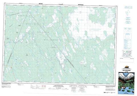
021A03 Lake Rossignol Canada topo map, 1:50,000 scale
021A03 Lake Rossignol NRCAN topographic map.
Includes UTM and GPS geographic coordinates (latitude and longitude). This 50k scale map is suitable for hiking, camping, and exploring, or you could frame it as a wall map.
Printed on-demand using high resolution, on heavy weight and acid free paper, or as an upgrade on a variety of synthetic materials.
Topos available on paper, Waterproof, Poly, or Tyvek. Usually shipping rolled, unless combined with other folded maps in one order.
- Product Number: NRCAN-021A03
- Parent Topo: TOPO-021A
- Map ID also known as: 021A03, 21A3, 21A03
- Unfolded Size: Approximately 26" high by 36" wide
- Weight (paper map): ca. 55 grams
- Map Type: POD NRCAN Topographic Map
- Map Scale: 1:50,000
- Geographical region: Nova Scotia, Canada
Neighboring Maps:
All neighboring Canadian topo maps are available for sale online at 1:50,000 scale.
Purchase the smaller scale map covering this area: Topo-021A
Spatial coverage:
Topo map sheet 021A03 Lake Rossignol covers the following places:
- Alick Bay - Coade Bay - Cowie Bay - East Bay - East Brook Bay - Fifth Lake Bay - Gaspar Bay - Kempton Bay - Long Bay - Matt Cove - Northeast Bay - Pug Cove - Southeast Arm - Southwest Arm - Yeadon Bay - Burnt Point - Moose Point - Pitman Point - Narrows of Roseway - Pitman Narrows - The Sluice - Horse Falls - Mountain Falls - Scotland Falls - Upset Falls - Digby - Queens - Shelburne - Yarmouth - Devils Island - Grayhorse Island - Hardwood Island - Long Island - Moosehead Island - Aspect Lake - Babs Lake - Back Lake - Bald Mountain Lake - Beartrack Lake - Berry Lake - Big Round Lake - Bingay Lakes - Black Duck Lake - Black Lake - Black-duck Lake - Blue Hill Mud Lake - Bluffhill Lake - Boot Lake - Bower Lake - Bowers Lake - Bowers Pond - Branch Lake - Broad River Lake - Broadriver Lake - Brophy Lake - Bullrush Lake - Caduesky Lake - Clamshell Lake - Coade Lake - Conway Lake - Crain Lake - Cranberry Lake - DeMoliter Lake - Dog Lake - Dr. Churchills Hole - Duck Ponds - East Bingay Lake - East Horseshoe Lake - Eighth Lake - First Beaver Lake - First Lake - First Lake - First Lake - First Round Lake - George Lake - Grandy Lake - Grass Lake - Great Pine Lake - Halfmoon Lake - Handsled Lake - Harlow Lake - Hodgson Lake - House Lake - Hugh Lake - Joe Flogger Pond - John Lake - John Lake - Jordan Lake - Junction Lake - Kempton Lake - Lake John - Lake Rossignol - Little Dispatch Lake - Little Pine Lake - Little Pug Lake - Little Rocky Lake - Little Silver Lake - Little Stony Lake - Little Tobeatic Lake - Little Tobeatik Lake - Little Tupper Lake - Little Whetstone Lake - Long Lake - Long Lake - Longview Lake - Lost Lake - Lower Branch Lake - Lower Porcupine Lake - Lower Stave Lake - Maclean Lake - Martin Lake - McAfee Lake - McGill Lake - Mink Lake - Moose Lake - Mullins Lake - Newmoon Lake - North Bingay Lake - Northeast Lake - Oscar Lake - Pug Lake - Pug Lake - Quinlan Lake - Quinlan Pond - Randy Lake - Ring Lakes - Rocky Pond - Roseway Lake - Rotund Lake - Round Lake - Rush Lake - Russia Lake - Sand Lake - Sand Ponds - Second Beaver Lake - Second Lake - Second Lake - Second Lake - Silver Lake - Silvery Lake - Siskech Lake - Sixth Lake - Skudiak Lake - Smith Lake - South Bingay Lake - Southwest Lake - Spectacle Lake - Swallow Lake - Three River Lake - Tobeatic Flowage - Tobeatic Lake - Tobeatik Lake - Trap Lake - Twin Lakes - Upper Branch Lake - Upper Porcupine Lake - Upper Stave Lake - Wainwright Lake - Wallace Lake - West Bingay Lake - West Horseshoe Lake - Whetstone Lake - Whitecap Lake - Bald Mountain - Crain Lake Mountain - Hackmatack Mountain - Harlow Hill - Indian Lookoff - McCoys Ridge - North Blue Hill - Owls Hill - Porcupine Hill - Rough Mountain - Argyle - Digby - Queens - Shelburne - Tobeatic Wildlife Management Area - Pollock Rapids - Starvation Eddy - Anderson Brook - Beaver Creek - Bennys Run - Blue Hill Brook - Bluehill Brook - Boot Lake Brook - Broad River - Caduesky Brook - Cat Creek - Coade Brook - Conway Brook - Cranberry Lake Brook - Dog Brook - Dog Lake Brook - Drawknife Run - Eight Mile Brook - Eightmile Brook - Granite Run - Handsled Lake Brook - Harlow Brook - House Lake Brook - Jacks Savannah Brook - Jordan River - Kempton Brook - Krautknife Brook - Logging Creek - Louis Brook - Martin Brook - Mersey River - Molasses Run - North Bald Mountain Brook - Oscar Lake Brook - Owlhill Brook - Owls Hill Brook - Porcupine Brook - Prince John Brook - Quinlan Creek - Roseway River - Run of Jordan - Runoff of Jordan - Russia Lake Brook - Sable River - Sand Brook - Savannah Brook - Scotland Creek - Shelburne River - Sixth Lake Brook - Sixth-lake Brook - South Bald Mountain Brook - Stoney Brook - Stony Brook - Sunken Brook - Thousand Acre Bog Brook - Tidney River - Tigney River - Wainwright Brook - Wallace Lake Brook - West Branch Jordan River - West Brook - West Jordan River - West Roseway Brook - Whetstone Mountain Brook - Hemlock Pothole - Jones Hole - Ottoman Stillwater - Sheepfarm Stillwater - Indian Gardens - Clear Bog - Dunraven Bog - Halfmoon Plains - Indian Fields - Minard Bog - Payzant Meadows - Thousand Acre Bog


