
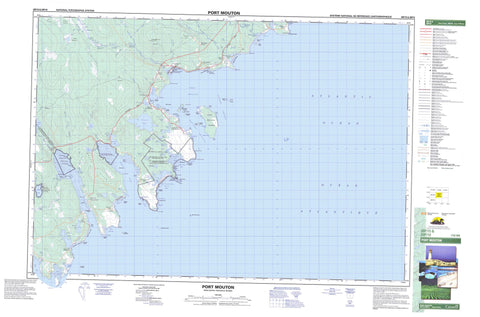
020P15 Port Mouton Canada topo map, 1:50,000 scale
020P15 Port Mouton NRCAN topographic map.
Includes UTM and GPS geographic coordinates (latitude and longitude). This 50k scale map is suitable for hiking, camping, and exploring, or you could frame it as a wall map.
Printed on-demand using high resolution, on heavy weight and acid free paper, or as an upgrade on a variety of synthetic materials.
Topos available on paper, Waterproof, Poly, or Tyvek. Usually shipping rolled, unless combined with other folded maps in one order.
- Product Number: NRCAN-020P15
- Parent Topo: TOPO-020P
- Map ID also known as: 020P15, 20P15
- Unfolded Size: Approximately 26" high by 36" wide
- Weight (paper map): ca. 55 grams
- Map Type: POD NRCAN Topographic Map
- Map Scale: 1:50,000
- Geographical region: Nova Scotia, Canada
Neighboring Maps:
All neighboring Canadian topo maps are available for sale online at 1:50,000 scale.
Purchase the smaller scale map covering this area: Topo-020P
Spatial coverage:
Topo map sheet 020P15 Port Mouton covers the following places:
- Birch Cove - Boyds Cove - Boyd's Rock Cove - Cadden Bay - Channel Cove - Duck Lake Bay - Fishers Cove - Forbes Cove - Gull Bay - House Cove - Isaacs Harbour - Island Cove - John Smiths Cove - Joli Basin - Jones Cove - Jones Harbour - Little Joli Bay - Little Port Hebert - Little Port Joli - Little Port Joli Basin - Little Port Joli Creek - Little Port L'Hebert - Long Cove - MacLeods Cove - New Building Cove - Newhouse Cove - Port Hebert - Port Joli - Port L'Hebert - Port Mouton - Rocky Cove - Sandy Bay - Sandy Cove - Schooner Cove - St. Catherines River Bay - Tarr Cove - The Cove - Timber Island Cove - Willow Cove - Back Beach - Boyds Beach - Carters Beach - Green Side Shore - Hatt Beach - Hunts Point Beach - Johnstons Beach - Jumping Jack Breaker - Lighthouse Beach - Sandy Bay Beach - St. Catherines River Beach - Summerville Beach - Tarr Cove Breaker - White Point Beach - Wobamkek Beach - Bell Point - Bills Point - Black Point - Black Point - Black Point - Broad Head - Broad River Head - Bull Point - Davenport Point - Dry Point - Duck Point - East Point - Forbes Point - Grosse Spit - Halibut Head - Hell Point - Hook Point - Hunts Point - Joli Point - Jones Harbour Point - MacDonald Point - Mitchell Point - Mouton Head - Port Joli Head - Port Mouton Head - Richardson Head - Scotch Point - Shingle Point - South Point - Strawberry Point - Stuarts Point - Thrum Point - Tillys Head - Western Head - White Point - Wreck Point - Eastern Channel - Western Channel - Campbells Falls - Queens - Shelburne - Big Timber Island - Carters Island - Charley Island - Daury Island - Grants Island - Green Island - Gull Island - Hardings Island - Jacket Island - Jackies Island - Johns Island - Lesser Hope Island - Little Hope Island - Little Timber Island - Massacre Island - Mink Island - Money Island - Mouton Island - Port Mouton Island - Sinclair Island - Spectacle Island - Spectacle Islands - Stuarts Island - Thrum Cap - Timber Island - Basin Lake - Boyds Cove Ponds - Bull Pond - Cameron Lake - Cove Lake - Cranberry Pond - Deep Lake - Doggetts Pond - Duck Hole - Duck Lake - Flat Lake - Flat Lake - Forbes Lake - Haley Lake - Head Pond - Huskins Pond - Johnston Pond - Johnstons Pond - Lillie Lake - Lily Lake - Little Duck Hole - Little Lake - Little Lake - Little Robertsons Lake - Long Lake - Louis Lake - McLean Lake - Meadow Lake - Moose Creek Pond - Path Lake - Robertson Lake - Robertsons Lake - Round Lake - Sandy Bay Round Lake - Sodom Lake - Southern Deep Lake - St. Catherine Lake - St. Catherines Lake - St. Catherines River Lake - Stewart Lake - Stuarts Lake - The Pond - Tripps Lake - Trips Lake - Victoria Lake - Wilkins Lake - Willis Lake - Beech Hill - Goose Hills - Hammetts Ridge - Queens - Shelburne - Annexe côtière du parc national Kejimkujik - Haley Lake Bird Sanctuary - Kejimkujik National Park of Canada - Kejimkujik National Park Seaside Adjunct - Parc national du Canada Kejimkujik - Port Hebert Bird Sanctuary - Port Hebert Migratory Bird Sanctuary - Port Joli Bird Sanctuary - Refuge d'oiseaux de Port Hébert - Refuge d'oiseaux de Port-Joli - Refuge d'oiseaux du lac Haley - Refuge d'oiseaux migrateurs de Port Hébert - Summerville Beach Provincial Park - Thomas Raddall Provincial Park - Broad River - Calfpen Brook - Carters River - Cox Creek - Cox Creek - Cox Creek Brook - Douglas Brook - East Branch Five Rivers - East Broad River - East Brook Five Rivers - Five River Creek - Five Rivers - Five Rivers Creek - Granite Brook - Granite Village Brook - Haley Lake Brook - Hemeon Brook - Indian Log Brook - Jones Creek - Little Lake Brook - London Brook - MacLarens Creek - Martin Brook - McAlpine Brook - McAlpines Brook - Mitchell Brook - Path Lake Brook - Payzant Brook - Reubens Brook - Rosies Brook - Sable River - St. Catherines River - Timber Island Brook - Timber-island Brook - Tobacco Brook - Vances Brook - Wagner Brook - Wagners Brook - Campbells Stillwater - Devils Funnel Stillwater - Long Point Stillwater - Maple Swamp Stillwater - McQuinns Stillwater - Seans Hole - Bantam - Bastard - Big Ball Rock - Big Ledges - Bijou Rocks - Boyds Reef - Brazil Rocks - Bull Rock - Burgess Rock - Darlings Rock - Deadmans Rock - Devastation Shoal - Entry Rock - Green Rock - Gull Shoal - Harbour Rocks - Hebert Rocks - Hebert Rocks - Herring Rocks - Lesser Hope Rock - L'Hebert Rocks - Little Ball Rock - Little Hope Shoal - MacLarens Rock - Main Ledges - Middle Rock - Moose Rock - Round Rock - Shingle Rock - South Rock - Spectacle Ledge - Spectacle Rock - The Blinds - The Old Bull - The Old Cow - Whaleback - White Point Rock - White Point Shoal - Beach Hill Farms - Beech Hill Farms - Central Port Mouton - East Side Port Hebert - East Side Port L'Hebert - Granite Village - Hunts Landing - Hunts Point - Little Port Hebert - Little Port L'Hebert - Port Hebert - Port Joli - Port L'Hebert - Port Mouton - River Head - Sandy Bay Landings - South West Port Mouton - St. Catherine River - St. Catherines River - Summerville Centre - Western Head - White Point - Wilkins - Cranberry Bog - Leslies Meadows - Payzant Meadows - Skullbone Bog - Sols Meadows


