
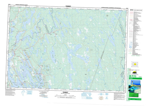
020P13 Tusket Canada topo map, 1:50,000 scale
020P13 Tusket NRCAN topographic map.
Includes UTM and GPS geographic coordinates (latitude and longitude). This 50k scale map is suitable for hiking, camping, and exploring, or you could frame it as a wall map.
Printed on-demand using high resolution, on heavy weight and acid free paper, or as an upgrade on a variety of synthetic materials.
Topos available on paper, Waterproof, Poly, or Tyvek. Usually shipping rolled, unless combined with other folded maps in one order.
- Product Number: NRCAN-020P13
- Parent Topo: TOPO-020P
- Map ID also known as: 020P13, 20P13
- Unfolded Size: Approximately 26" high by 36" wide
- Weight (paper map): ca. 55 grams
- Map Type: POD NRCAN Topographic Map
- Map Scale: 1:50,000
- Geographical region: Nova Scotia, Canada
Neighboring Maps:
All neighboring Canadian topo maps are available for sale online at 1:50,000 scale.
Purchase the smaller scale map covering this area: Topo-020P
Spatial coverage:
Topo map sheet 020P13 Tusket covers the following places:
- Bourques Cove - Burke Cove - Chebeck Cove - Glenwood Bay - Horse Creek - Indian Bay - Indian Sluice Bay - Kenny Cove - Roberts Anchorage - Salt Bay - The Basin - Vacons Cove - Arnold Point - Beach Point - Brandy Point - Burrills Point - Crowell Point - Far Point - Fox Point - Fox Point - Green Point - High Head - Hubbards Point - Indian Point - Long Point - McKinnon Neck - Moodys Point - Moose Point - Muises Point - Northwest Point - Rocco Point - Sluice Point - Tête à Milie - Vacons Point - Websters Point - Wedgeport Cape - Big Sluice - Crazy Pass - Eastern River - Indian Sluice - La Grande Passe - Little Sluice - The Bar - The Narrows - The Narrows - The Narrows - The Sluice - Bad Falls - Big Falls - Carrying Falls - Cobbs Scutch Falls - Eel Weir Falls - Franks Falls - Gridiron Falls - Grid-iron Falls - Hemlock Falls - Indian Falls - Long Falls - Longs Falls - Martin Falls - Middle Clyde Falls - Middle Falls - Moodys Falls - Nickersons Falls - Old Bridge Falls - Potomac Falls - Rocky Creek Falls - Slate Falls - Snows Falls - Trap Falls - Tree Falls - Trout Hole Falls - Tusket Falls - Wilsons Falls - Shelburne - Yarmouth - Abbotts Dyke - Big Island - Bills Island - Birch Island - Birch Island - Birch Island - Bourques Island - Briar Island - Butter Island - Calf Island - Cat Island - Cornelius Island - Devils Island - Dyes Island - Eagle Island - Ensors Island - Far Point Island - Far-point Island - Flick Island - Fox Island - Gunning Island - Hare Island - Harts Island - Hay Islands - Little Calf Island - Maple Island - Meeting Island - Mike Island - Mikes Island - Mikes Little Island - Morris Island - Pitmans Island - Pothiers Island - Rabbit Island - Ram Islands - Roberts Island - Ryders Island - Slokums Island - Smith Island - Squires Island - Surettes Island - Tinkhams Island - Upper Frost Island - Widgegum Islands - Agard Lake - Argyle Long Lake - Back Lake - Bannockburn Pond - Barclay Lake - Barren Lake - Beaver Lake - Beaver Pond - Bennet Lake - Bennets Lake - Bennetts Lake - Big Gull Lake - Big Squambow Lake - Biggars Lake - Bigger Lake - Bird Lake - Bloody Lake - Bucks Lake - Butler Lake - Butler Lake - CanoeLake - Carleton Lake - Clam Lake - Clearwater Lake - Clearwater Lake - Clyde River Beaver Pond - Cocos Pond - Cranberry Lake - Crane Lake - Currys Pond - Currys Ponds - Duck Lake - Duck Pond - Duck Pond - East Corning Lake - East Goose Lake - Eastern Duck Pond - Eds Ponds - Eel Lake - Elbow Lake - Ellenwood Lake - Engineering Lake - English Clearwater Lake - Franks Lake - Freemans Lake - French Clearwater Lake - Frost Lake - Frostfish Lake - Frost-fish Lake - Frosts Pond - Gavel Lake - Gavels Lake - Gilfilling Lake - Gillfillan Lake - Gold Lake - Great Barren Lake - Great Barren Lake Flowage - Great Pubnico Lake - Gridiron Lake - Gull Lake - Halfway Lake - Harris Lake - Herring Lake - Hibbards Lake - Hibbert Lake - Hog Lake - Hooper Lake - Hoopers Lake - Hudson Bay Lake - James Lake - Jeromes Lake - Joes Pond - Kegeshook Lake - Kempt Snare Lake - Kings Lake - Lac à Pic - Lac de l'École - Lake Vaughan - Lincumdoddy Lake - Little Bear Lake - Little Gull Lake - Little Halfway Lake - Little Lake - Little Madashack Lake - Little Round Lake - Little Round Lake - Little Rushy Lake - Little Rushy Lake - Little Squambow Lake - Loch An Duach - Loch Dutch - Lochan Duach - Long Lake - Long Lake - Louis Lake - Madashack Lake - Marcel Lake - McGill Lake - Mespark Lake - Mickchickchawagata Lakes - Mikchickche-chewagatha Lakes - Mikchik Lakes - Mill Lake - Mingo Beck Lake - Moses Hill Ponds - Moses Lake - Mushpauk Lake - Naustaush Pond - Nessisse Lake - Nonias Lake - Northern Duck Ponds - Pats Scooping Place - Peter Lake - Peters Lake - Pothiers Millpond - Priscilla Lake - Pulldozen Lake - Pulleydoggen Lake - Quinan Duck Lake - Quinan Lake - Randal Lake - Randals Lake - Raynards Lake - Raynardton Beaver Pond - Ricker Lake - Rickers Lake - Rory Lake - Rorys Lake - Rushy Lake - Ryer Lake - Salter Lake - Sand Pond - Second Lake - Shunacadie Lake - Sloan Lake - Sloans Lake - Snare Lake - Somes Lake - South Clearwater Lake - South Horseshoe Lake - Spar Lake - Spark Lake - Springhaven Duck Lake - Third Lake - Turtle Pond - Vaughan Lake - Wagners Lake - Wallubek Lake - West Clearwater Lake - Western Duck Pond - Westmore Lake - Westmorland Lake - Wilsons Lake - Goodwins Ridge - Jacksons Mountain - Kiahs Hill - Moses Hill - North Roberts Hill - Roberts Hill - Spar Ridge - Spinney Hill - Argyle - Barrington - Shelburne - Yarmouth - Ellenwood Lake Provincial Park - Glenwood Provincial Park - Réserve nationale de faune de Sand Pond - Sand Pond National Wildlife Area - Franks Eddy - Indian Eddy - Peters Rapids - The Branch Shoals - The Guaygus - The Horserace - Abram River - Abrams River - Absaloms Run - Annis River - Argyle Back River - Argyle River - Back River Brook - Bannockburn Brook - Bearden Brook - Beaver Brook - Big Falls Brook - Birch Hill Creek - Birch Run - Bloody Creek - Bog Brook - Campbells Hill Brook - Carleton River - Cavanaghs Run - Clearwater Lake Brook - Clyde River - Cold Stream - Cranberry Brook - Davis River - Duck Brook - East River - Engineering Lake Brook - Fresh River - Hamilton Branch - Hamilton Creek - Harper Creek - Hills Meadow Brook - Kiack Brook - Lincumdoddy Brook - Little Bear Lake Brook - Mushpauk Brook - Nonias Lake Brook - Northwest Branch - Pats Meadow Brook - Peters Brook - Porcupine Brook - Potter Run Brook - Potters Run - Quinan River - Roaring Brook - Rocky Creek - Salmon Creek - Shunacadie Brook - Silver River - Spar Brook - Squambow Brook - Trout Hole Brook - Tusket River - Welchards Brook - Goudeys Stillwater - Naustaush Eel Pot - Old Mill Stillwater - The Billy Hole - The Trout Hole - Bar Rock - Gunning Ledge - Quinan Meat Rock - Abram River - Abrams River - Amirault Hill - Amiraults Hill - Argyle - Argyle - Argyle Head - Bell Neck - Belleville - Belleville North - Belleville South - Brazil Lake - Canaan - Central Argyle - Crosby - Deerfield - East Quinan - Eel Brook - Gavelton - Glenwood - Hubbard Point - Hubbards Point - Lower Eel Brook - Middle Clyde River - Morris Island - Pleasant Valley - Pleasant Valley Corner - Quinan - Raynardton - Reynard Bridge - Reynardton - Roberts Island - Sluice Point - South Canaan - South Deerfield - South Quinan - Springhaven - Ste. Anne du Ruisseau - Surette Island - Surettes Island - Tusket - Tusket Falls - Upper Wedgeport - Coffin Meadow - Croshes Meadow - Gavels Meadow - Goose Heath - Great Heath - Hills Meadow - Pats Meadow - Spinneys Heath - Sturgess Bog


