
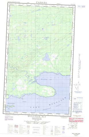
013G13W Mulligan Bay Canada topo map, 1:50,000 scale
013G13W Mulligan Bay NRCAN topographic map.
Includes UTM and GPS geographic coordinates (latitude and longitude). This 50k scale map is suitable for hiking, camping, and exploring, or you could frame it as a wall map.
Printed on-demand using high resolution, on heavy weight and acid free paper, or as an upgrade on a variety of synthetic materials.
Topos available on paper, Waterproof, Poly, or Tyvek. Usually shipping rolled, unless combined with other folded maps in one order.
- Halfsheet: This map was designed as a half sheet of NRCAN-013G13, and it is the Western half. Find the eastern half sheet here.
- Product Number: NRCAN-013G13W
- Parent Topo: TOPO-013G
- Map ID also known as: 013G13, 13G13
- Unfolded Size: Approximately 26" high by 36" wide
- Weight (paper map): ca. 55 grams
- Map Type: POD NRCAN Topographic Map
- Map Scale: 1:50,000
- Geographical region: Newfoundland and Labrador, Canada
Neighboring Maps:
All neighboring Canadian topo maps are available for sale online at 1:50,000 scale.
Purchase the smaller scale map covering this area: Topo-013G
Spatial coverage:
Topo map sheet 013G13W Mulligan Bay covers the following places:
- Acadia Anchorage - Coleys Arm - Double Mer - Hamilton Inlet - Mulligan Bay - Sebaskachu Bay - Black Point - Burned Point - Nebavik Point - Upper Long Point - Chevrier Island - Long Island - Pearl Island - Lake Melville - Mulligan Hills - Coleys Brook - Mulligan River - Pearl River - Rattling Brook - Long Island Shoals - Mulligan Rock - Mulligan Shoal - Nebavik Shoals


