
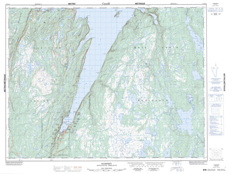
012H10 Hampden Canada topo map, 1:50,000 scale
012H10 Hampden NRCAN topographic map.
Includes UTM and GPS geographic coordinates (latitude and longitude). This 50k scale map is suitable for hiking, camping, and exploring, or you could frame it as a wall map.
Printed on-demand using high resolution, on heavy weight and acid free paper, or as an upgrade on a variety of synthetic materials.
Topos available on paper, Waterproof, Poly, or Tyvek. Usually shipping rolled, unless combined with other folded maps in one order.
- Product Number: NRCAN-012H10
- Parent Topo: TOPO-012H
- Map ID also known as: 012H10, 12H10
- Unfolded Size: Approximately 26" high by 36" wide
- Weight (paper map): ca. 55 grams
- Map Type: POD NRCAN Topographic Map
- Map Scale: 1:50,000
- Geographical region: Newfoundland and Labrador, Canada
Neighboring Maps:
All neighboring Canadian topo maps are available for sale online at 1:50,000 scale.
Purchase the smaller scale map covering this area: Topo-012H
Spatial coverage:
Topo map sheet 012H10 Hampden covers the following places:
- Bailey Cove - Bear Gulch - Browns Cove - Burdens Cove - Burnt Head Cove - Clay Cove - Country Cove - East Anchorage - Georges Cove - Gold Cove - Gooseberry Cove - Hampden Bay - Hannah Cove - Little Pumbly Cove - Little Spear Cove - Morgan Cove - Natlins Cove - Pumbly Cove - Purbeck's Cove - Saltwater Cove - Sops Arm - South Anchorage - Spear Cove - Sprucy Cove - West Anchorage - White Bay - White Head Cove - Baie Verte Peninsula - Clift Point - Fox Point - Lower Head - Mohawk Point - Northern Peninsula - Oody Point - Otter Point - Pollards Point - Spear Point - Twelve Mile Point - Upper Head - Western Head - Doone Island - Granby Island - Millers Island - Ansteys Fifth Pond - Ansteys First Pond - Ansteys Fourth Pond - Ansteys Second Pond - Ansteys Third Pond - Bailey Cove Pond - Bald Eagle Pond - Beaver Pond - Big Davis Pond - Black Duck Ponds - Black Lake - Carl Pond - Chouse Brook Steadies - Clam Pond - Corner Brook Pond - Country Cove Pond - Crooked Pond - Deer Pond - Deer Pond - Dock Pond - Downs Pond - George Ricks Pond - Georges Pond - Giles Pond - Gull Lake - Gull Pond - Headwater Pond - Little Davis Pond - Long Pond - Long Pond - Manuels Lake - Micmac Pond - Misty Pond - Moose Lake - Natlins Pond - Pittmans Pond - Rattling Brook Ponds - Rocky Pond - Rocky Pond - Round Pond - Round Pond - Saltwater Pond - Sand Pond - Second Saltwater Pond - Side Pond - Spear Cove First Pond - Spear Cove Second Pond - Tar-Barrel Pond - Taylors Pond - Trout Pond - Trout Pond - Unknown Pond - Upper Indian Pond - White Bottom Pond - White Head Pond - Wild Beach Pond - Wild Cove Pond - Wild Pond - Will Hynes Pond - Wissen Pond - Bess Hill - Corner Hill - Dough-Boy Hill - Green Hill - Long Range Mountains - Mount Allgood - Mount Bourke - Mount Campbell - Mount Corbett - Mount de Robeck - Mount Eleanor - Mount Ella - Mount Fleming - Mount Haggarty - Mount Lockyer - Mount Moorshead - Mount Seeton - Mount Winifred - Oody Mountain - Simms Ridge - The Pinnacle - Tokalok - Alder Brook - Ansteys Brook - Big Chouse Brook - Black Brook - Black Duck Brook - Corner Brook - Doucers Brook - Eliot Brook - Falls Brook - Gales Brook - Goose Brook - Hampden River - Little Chouse Brook - Main Brook - Natlins Brook - Nobles Brook - North Big Chouse Brook - North Brook - Purbecks Brook - Purbeck's Brook - Rattling Brook - Rocky Brook - Saltwater Brook - West Hampden River - Wild Cove Brook - Bird Rock - Francis Reef - Gull Rock - Shag Rock - Hampden - Bayside - Beaches - Browns Cove - Burtons Cove - Galeville - Georges Cove - Gold Cove - Granby Island - Hannah Cove - Little Pumbly Cove - Pollards Point - Pollard's Point - Pumbly Cove - Purbeck's Cove - Sprucy Cove - The Beaches - Caribou Valley - Browns Cove Barrens - Corner Brook Barrens


