
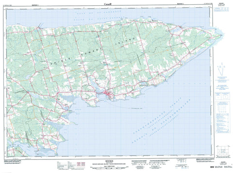
011L08 Souris Canada topo map, 1:50,000 scale
011L08 Souris NRCAN topographic map.
Includes UTM and GPS geographic coordinates (latitude and longitude). This 50k scale map is suitable for hiking, camping, and exploring, or you could frame it as a wall map.
Printed on-demand using high resolution, on heavy weight and acid free paper, or as an upgrade on a variety of synthetic materials.
Topos available on paper, Waterproof, Poly, or Tyvek. Usually shipping rolled, unless combined with other folded maps in one order.
- Product Number: NRCAN-011L08
- Parent Topo: TOPO-011L
- Map ID also known as: 011L08, 11L8, 11L08
- Unfolded Size: Approximately 26" high by 36" wide
- Weight (paper map): ca. 55 grams
- Map Type: POD NRCAN Topographic Map
- Map Scale: 1:50,000
- Geographical region: Prince Edward Island, Canada
Neighboring Maps:
All neighboring Canadian topo maps are available for sale online at 1:50,000 scale.
Purchase the smaller scale map covering this area: Topo-011L
Spatial coverage:
Topo map sheet 011L08 Souris covers the following places:
- Basin Head Harbour - Bay Fortune - Blackett Creek - Blacketts Creek - Boughton Bay - Campbell Cove - Campbells Cove - Colville Bay - Eglington Cove - Eglinton Cove - Fortune Bay - Golfe du Saint-Laurent - Gulf of St. Lawrence - Hervey Cove - Howe Bay - Little Harbour - McFarlane Cove - Naufrage Harbour - North Lake Harbour - Rollo Bay - Souris Harbour - Spry Cove - Spry Cove - The Inlet - Fortune Beach - Abells Cape - Banks Point - Basin Head - Bayfield Point - Campbell Point - Campbell Point - Campbells Point - Cape Abell - Cape Spry - Chaffeys Point - Chapel Point - Chepstow Point - Deane Point - Durell Point - Grey Point - Howe Point - Jimmys Point - Juniper Point - Knight Point - Lobster Point - Long Point - Macdonald Point - McKinnon Point - Narrow Point - Narrows Point - Old Ferry Spit - Point Poplar - Poplar Point - Red Point - Red Point - Rollo Point - Sandie Point - Sheep Head - Shipwreck Point - Short Point - Souris Head - Spry Point - Surveyor Point - Swanton Point - Sylvester Point - Détroit de Northumberland - Northumberland Strait - Kings - Lot 42 - Lot 43 - Lot 44 - Lot 45 - Lot 46 - Lot 47 - Lot 55 - Lot 56 - Prince Edward Island - Big Pond - Black Pond - Diligent Pond - Dixons Pond - East Lake - Gillis Pond - Jenkins Pond - Johnny Belinda Pond - Larkins Pond - Leslies Pond - Little Harbour Pond - Little Pond - MacDonalds Pond - MacInnis Pond - MacInnis Pond - MacVanes Pond - McVarishs Pond - Naufrage Pond - Norris Pond - North Lake - Priest Pond - Sheep Pond - South Lake - Black Pond Bird Sanctuary - Campbells Cove Provincial Park - Red Point Provincial Park - Refuge d'oiseaux de Black Pond - Souris Beach Provincial Park - Townshend Woodlot Provincial Park - Île-du-Prince-Édouard - Prince Edward Island - Big Run - Bear River - Big Brook - Black Creek - Boughton River - Bull Creek - Cow Creek - Cow River - Crooked River - Crooked River - Cross River - East Lake Creek - Fortune River - Fox River - Grovepine Brook - Harmony Creek - Hay River - Little River - Malcolm Creek - Narrow Creek - Narrows Creek - Naufrage River - North Lake Creek - Priest Pond Creek - Souris River - St. Peters River - West River - Middle Ground - Shallop Rock - Souris - Albion Cross - Annandale - Armadale - Baltic - Bay Fortune - Bayfield - Bear River - Big Pond - Bothwell - Campbell Cove - Campbells Cove - Charnwood - Chepstow - Cherry Grove - Clear Spring - Clearspring - Connaught - Dingwell - Dingwell Mills - Dingwells Mills - Durell - East Baltic - East Point - Eglington - Elmira - Fairfield - Farmington - Fortune Bay - Fortune Bridge - Fortune Harbour - Fountain Head - Glencorradale - Gowan Brae - Gowanbrae - Greenvale - Harmony - Harmony Junction - Hermanville - Howe Bay - Kingsboro - Kingsborough - Lakeville - Little Harbour - Little Pond - Lot 56 - Lower Rollo Bay - Mansfield - Monticello - Mount Hope - Munns Road - Naufrage - New Acadia - New Acadie - New Harmony - New Zealand - North Lake - North Lakeville - Point Poplar - Poplar Point - Priest Pond - Red House - Red Point - Rock Barra - Rollo Bay - Rollo Bay East - Rollo Bay West - Sailors Hope - Selkirk - Souris East - Souris Line Road - Souris River - Souris West - South Lake - St. Catherines - St. Charles - St. Georges - St. Margaret - St. Margarets - Annandale-Little Pond-Howe Bay - Central Kings - Eastern Kings - Souris West


