
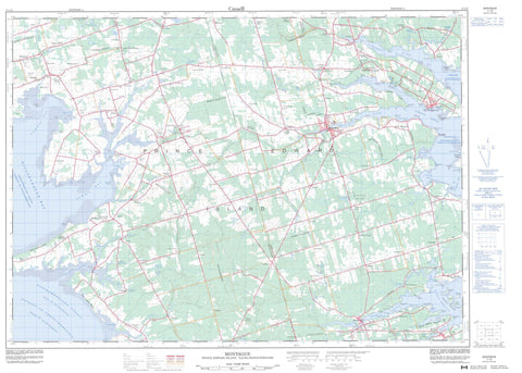
011L02 Montague Canada topo map, 1:50,000 scale
011L02 Montague NRCAN topographic map.
Includes UTM and GPS geographic coordinates (latitude and longitude). This 50k scale map is suitable for hiking, camping, and exploring, or you could frame it as a wall map.
Printed on-demand using high resolution, on heavy weight and acid free paper, or as an upgrade on a variety of synthetic materials.
Topos available on paper, Waterproof, Poly, or Tyvek. Usually shipping rolled, unless combined with other folded maps in one order.
- Product Number: NRCAN-011L02
- Parent Topo: TOPO-011L
- Map ID also known as: 011L02, 11L2, 11L02
- Unfolded Size: Approximately 26" high by 36" wide
- Weight (paper map): ca. 55 grams
- Map Type: POD NRCAN Topographic Map
- Map Scale: 1:50,000
- Geographical region: Prince Edward Island, Canada
Neighboring Maps:
All neighboring Canadian topo maps are available for sale online at 1:50,000 scale.
Purchase the smaller scale map covering this area: Topo-011L
Spatial coverage:
Topo map sheet 011L02 Montague covers the following places:
- Belfast Cove - Cantalo Creek - Cardigan Bay - Cherry Valley Cove - Clarks Bay - Gascoigne Cove - Gascoygne Cove - Gascoyne Cove - Georgetown Harbour - Golfe du Saint-Laurent - Gulf of St. Lawrence - Hillsborough Bay - Holm Cove - Livingstone Bay - Log Cove - Long Creek - Murray Harbour - Nicolle Cove - Nortons Creek - Orwell Bay - Orwell Cove - Philip Cove - Pinette Harbour - Pownal Bay - Pownall Bay - Robinsons Cove - St. Mary Bay - St. Marys Bay - Stewart Cove - Sturgeon Bay - Macphee Beach - MacPhee Beach - Maitland Flat - Morrison Beach - Wheeler Bar - Wheelers Bar - Aitken Point - Bethunes Point - Big Point - Billhook Point - Birch Point - Bottle Point - Brudenell Point - Buchanan Point - Buxtons Point - Campbell Point - Campbell Point - Centia Point - China Point - Clarke Point - Clows Point - Crawford Point - Crown Point - Cuddys Point - Davies Point - Dewars Point - Doctors Point - Douse Point - Dowden Point - Fairchild Point - Ferry Point - Finlaysons Point - Finleys Point - French Marsh Point - French Point - French Point - Gallas Point - Gallows Point - Gaudin Point - Gordon Point - Grave Point - Grays Point - Haleys Point - Haydens Point - Indian Point - Irvings Bar - Jennys Point - Jenyns Point - Jobs Point - Kirbys Point - Landrys Point - Machons Point - MacLeods Point - Maitland Point - Marsh Point - McInnis Point - McInnis Point - McInnis Point - McInnis Point - Meadowfoot Point - Miller Point - Moores Point - Mutchs Point - Muttock Point - Nicolle Point - Orwell Point - Panmure Spit - Parkers Point - Penn Point - Philip Point - Pinette Point - Pleasant Point - Point Pleasant - Pond Point - Pownal Peninsula - Pownal Point - Pownall Point - Richards Point - Richards Point - Sandy Point - Saunders Point - Selkirk Point - Sharams Point - Shaws Point - St. Andrew Point - Thornton Point - Thrumcap Spit - White Point - Whites Point - Wight Point - Wightmans Point - Winter Point - Détroit de Northumberland - Northumberland Strait - The Bluff - Georgetown - Kings - Lot 48 - Lot 49 - Lot 50 - Lot 51 - Lot 52 - Lot 53 - Lot 54 - Lot 57 - Lot 58 - Lot 60 - Lot 61 - Lot 62 - Lot 63 - Lot 64 - Lot 66 - Queens - Brudenell Island - Brudenell Islet - Buchanan Island - Cherry Island - Christie Island - Gordons Island - Herring Island - Murray Islands - Poxy Island - Prince Edward Island - Reynolds Island - Ronald Island - Thomas Island - Thrumcap Island - Thrumcap Islet - Brooklyn Pond - Clarks Pond - Cooks Pond - Creeds Pond - Dewars Pond - Finlaysons Pond - Fitzpatricks Pond - Heatherdale Pond - Jenkins Pond - Jenkins Ponds - Jordans Pond - Keefes Lake - Knox Pond - Lake Verde - Little Lake - MacDonalds Pond - MacKenzie Pond - MacLeans Pond - MacLeods Pond - MacLures Pond - MacMillans Pond - MacNeills Pond - MacPhails Pond - MacPhersons Pond - Martins Pond - Mathesons Pond - Mellishs Pond - Moores Sanctuary Ponds - Moss Lake - Munns Pond - O'Keefe Lake - O'Keefes Lake - Prowses Pond - Prowses Pond - Roseberry Pond - Roseberry Twin Ponds - Ross Pond - Stewarts Pond - Stewarts Pond - Sutherlands Pond - Thompsons Pond - Upper MacLures Pond - Valleyfield Pond - Worths Pond - Jones Hill - Lawtons Hill - Tea Hill - Brudenell Provincial Park - Brudenell River Provincial Park - Brush Wharf Provincial Park - Buffaloland Provincial Park - Fantasyland Provincial Park - Lord Selkirk Provincial Park - Pinette Provincial Park - Poole's Corner Provincial Park - Sir Andrew MacPhail Provincial Park - Île-du-Prince-Édouard - Prince Edward Island - Belle River - Bradley Creek - Browns Creek - Browns Creek - Brudenell River - Byrnes Creek - Cahoon Creek - Cardigan River - China Creek - Clark Brook - Clarks Brook - Clarks Creek - Deep Ravine Mill Brook - Dirty Creek - Dirty River - Dowden Creek - Flat River - Fox River - French Creek - Glenfinnan River - Greek River - Indian Creek - Johnstons River - Llewellyns Creek - Log Cove Creek - Martins Creek - Middle Creek - Middle Pinette River - Mill Creek - Mink River - Mitchell River - Montague River - Murray River - Newtown River - North Branch Pinette River - Orwell River - Pinette River - Pinette River - Pisquid River - Robertson Creek - Ross Creek - Rourkes Creek - Saunders Creek - Seal River - Seal River - South Branch Pinette River - South Branch Sturgeon River - South River - Sturgeon Creek - Sturgeon River - Thompson Creek - Valleyfield River - Vernon River - Vesseys Creek - Watts Creek - West Branch Sturgeon River - Wrights Creek - Big Basin - Little Basin - Knoll Shoal - MacPhee Shoal - Macphee Shoal - Pinette Shoals - Thrumcap Shoal - Youngs Shoal - Georgetown - Montague - Aitken Ferry - Alberry Plains - Albion - Alliston - Avondale - Beaton Mills - Beatons Mills - Belfast - Belfast - Bellevue - Bethel - Birch Hill - Brooklyn - Brudenell - Burnt Point - Caledonia - Cambridge - Cambridge Road - Cardigan - Cardigan North - Cherry Valley - Cherry Valley South - China Point - Clarkin - Commercial Cross - Culloden - Dover - Earnscliffe - Eldon - Elliotvale - Emmerson - Flat River - Fodhla - Gairloch - Garfield - Gladstone - Glasbhein - Glen Forest - Glencoe - Glenforest - Glenmartin - Glenwilliam - Grandview - Grandview Station - Greenfield - Greenmarsh - Hazelbrook - Head of Cardigan - Head of Montague - Heatherdale - Hermitage - Hopefield - Iona - Iris - Kilmuir - Kinlock - Kinross - Lake Verd - Lake Verde - Lewes - Lower Montague - Lower Newtown - Lyndale - Melville - Milltown - Milltown Cross - Millview - Mitchell River - Montague Junction - Mount Albion - Mount Buchanan - Mount Mellick - Mount Vernon - Mountmellick - Murray Harbour North - Murray Harbour West - New Perth - Newport - Newtown - Newtown Cross - North Pinette - Ocean View - Orwell - Orwell Cove - Perth - Peters Road - Pinette - Point Pleasant - Point Prim - Pooles Corner - Port Selkirk - Pownal - Pownall - Robertson - Roseberry - Roseneath - Seal River - Seal River - Selkirk Road - St. Mary Road - St. Marys Road - St. Mary's Road - Sturgeon - Summerville - Surrey - Uigg - Union Road - Valley - Valleyfield - Vernon - Vernon Bridge - Vernon River - Victoria Cross - Village Green - Village Green Station - Waterside - Whim Road - Wilmot - Woodville Mills - French Marsh - Throggys Marsh - Youngs Marsh - Belfast - Brudenell - Cardigan - Hazelbrook - Lorne Valley - Lower Montague - Murray Harbour - Murray River - Valleyfield


