
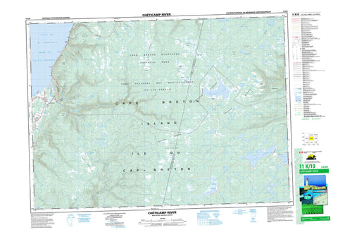
011K10 Cheticamp River Canada topo map, 1:50,000 scale
011K10 Cheticamp River NRCAN topographic map.
Includes UTM and GPS geographic coordinates (latitude and longitude). This 50k scale map is suitable for hiking, camping, and exploring, or you could frame it as a wall map.
Printed on-demand using high resolution, on heavy weight and acid free paper, or as an upgrade on a variety of synthetic materials.
Topos available on paper, Waterproof, Poly, or Tyvek. Usually shipping rolled, unless combined with other folded maps in one order.
- Product Number: NRCAN-011K10
- Parent Topo: TOPO-011K
- Map ID also known as: 011K10, 11K10
- Unfolded Size: Approximately 26" high by 36" wide
- Weight (paper map): ca. 55 grams
- Map Type: POD NRCAN Topographic Map
- Map Scale: 1:50,000
- Geographical region: Nova Scotia, Canada
Neighboring Maps:
All neighboring Canadian topo maps are available for sale online at 1:50,000 scale.
Purchase the smaller scale map covering this area: Topo-011K
Spatial coverage:
Topo map sheet 011K10 Cheticamp River covers the following places:
- Anse à Bois Meré - Golfe du Saint-Laurent - Gulf of St. Lawrence - Corney Beach - Cap Rouge - Pointe à la Petite Praire - Presqu'ile - Grande Falaise - Inverness - Juste au Corps - Victoria - Cape Breton Island - Île du Cap-Breton - Artemise Lake - Baldwin Lake - Beaver Lake - Benjies Lake - Caribou Lakes - Chéticamp Flowage - Chéticamp Lake - Clyburn Lake - Cranberry Lake - Dauphiney Lake - Duck Lake - Dundas Lakes - Étang à Johnny à Eusèbe - Fenton Lake - Fishing Cove Lake - Flint Lake - French Lake - French Lake - French River Lakes - Gisborne Flowage - Gisborne Lake - Gull Lake - Indian Lake - Jim Campbells Lake - Knob Lake - Lacs des Plées Ferrées - Lake of Islands - Lake of the Islands - LeBlanc Lake - Long Lake - Mathesons Lake - McMillan Flowage - Moose Lake - Pembroke Lake - Petit Étang - Rocky Pond - Roger Lake - Roper Lake - Shank Lake - Snowshoe Lake - Soapstone Lake - South Lake - Stoney Lake - Sunday Lake - Swamp Lake - Tipover Lake - Trout Lakes - Two Island Lake - West Lake - White Hill Lake - Wreck Cove Flowage - Wreck Cove Lakes - French Mountain - Indian Rising - Jerome Mountain - Klondike Mountain - Montagne Noire - The Pinnacle - White Hill - Inverness - Victoria - Cape Breton Highlands National Park of Canada - Parc national du Canada des Hautes-Terres-du-Cap-Breton - Alder Brook - Anthony Aucoins Brook - Artemise Brook - Au Coin Brook - Aucoin Brook - Benjies Lake Brook - Big Southwest Brook - Black Brook - Calumruadh Brook - Campbell Brook - Canadian Brook - Chéticamp River - Clyburn Brook - Coinneach Brook - Corney Brook - Curtis Brook - Daphiné Brook - Dauphiney Brook - Dundas Brook - East Branch Indian Brook - Factory Brook - Faribault Brook - Farm Brook - Fern Brook - Fiset Brook - Fishing Cove River - Fisset Brook - Forest Glen Brook - French River - Indian Brook - Ingonish River - Jerome Brook - Jim Campbells Brook - Jumping Brook - LeBlanc Brook - MacInnis Brook - MacKeigans Brook - Mackenzie River - MacKenzies River - MacLeods Brook - McKinnon Brook - McLeod Brook - McMillan Brook - McMillans Brook - Mill Brook - North Aspy River - North Branch Northeast Margaree River - Northeast Margaree River - Power Brook - Rigwash Brook - Robert Brook - Rocky Brook - Rocky Brook - Roper Brook - Ruisseau des Habitations Neuves - Ruisseau des Plées Ferrées - Second Fork Brook - Snipe Brook - Soapstone Brook - South Branch Corney Brook - South Calumruadh Brook - South Clyburn Brook - South Fishing Cove River - Trout Brook - Turner Brook - Warren Brook - West Branch Indian Brook - West Indian Brook - West Indian River - Wildcat Brook - Wreck Cove Brook - Blue Pool - Channel Pool - MacKays Pool - Number One Pool - Number Three Pool - Number Two Pool - Reids Pool - Rocky Pool - Three Brooks Pool - Two Brooks Pool - Jerome Ledge - Pillar Rock - Belle Marche - Belle-Marche - La Prairie - Petit Etang - Petit Étang - Petit-Etang - Petit-Étang - Rigwash à Bernard - Rigwash à Besure - Bakeapple Barren - Big Barren - Caribou Barren - Chéticamp Flats - Cranberry Barren - Everlasting Barrens - Ingonish Barrens - Island Barren - Jim Campbells Barren - North Barren - Rocky Barren - The Big Marsh - Western Barren


