
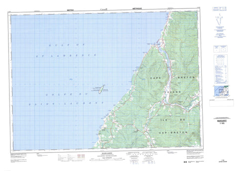
011K06 Margaree Canada topo map, 1:50,000 scale
011K06 Margaree NRCAN topographic map.
Includes UTM and GPS geographic coordinates (latitude and longitude). This 50k scale map is suitable for hiking, camping, and exploring, or you could frame it as a wall map.
Printed on-demand using high resolution, on heavy weight and acid free paper, or as an upgrade on a variety of synthetic materials.
Topos available on paper, Waterproof, Poly, or Tyvek. Usually shipping rolled, unless combined with other folded maps in one order.
- Product Number: NRCAN-011K06
- Parent Topo: TOPO-011K
- Map ID also known as: 011K06, 11K6, 11K06
- Unfolded Size: Approximately 26" high by 36" wide
- Weight (paper map): ca. 55 grams
- Map Type: POD NRCAN Topographic Map
- Map Scale: 1:50,000
- Geographical region: Nova Scotia, Canada
Neighboring Maps:
All neighboring Canadian topo maps are available for sale online at 1:50,000 scale.
Purchase the smaller scale map covering this area: Topo-011K
Spatial coverage:
Topo map sheet 011K06 Margaree covers the following places:
- Anse des Arsenault - Anse des Delaney - Anse des Doucet - Broad Cove - Dawsons Cove - Friars Head Boat Harbour - Gillis Cove - Golfe du Saint-Laurent - Gulf of St. Lawrence - MacDonalds Cove - MacNeils Cove - Margaree Harbour - Petite Église Cove - Plaster Rocks Cove - Simon Neils Cove - Whale Cove - Belle Côte Beach - Chimney Corner Beach - Donks Beach - Kennedys Shore - MacKinnons Beach - MacLellans Shore - MacLeods Beach - MacLeods Shore - MacPhersons Shore - MacRaes Beach - McLeod's Beach - Cape Grey - Chimney Corner - Côte des Cadet - East Point - Gillis Point - Grey Point - MacKays Cape - Marsh Point - Mizies Point - Smiths Point - West Point - Whale Head - Inverness - Juste au Corps - Margaree 25 - Cape Breton Island - Île du Cap-Breton - Margaree Island (Sea Wolf Island) - Arsenaults Pond - Bulger Pond - Cormier Lake - MacLeods Ponds - McNeils Pond - Pembroke Lake - Petit Lac - St. Rose Pond - Arsenaults Hill - Beatons Mountain - Donks Mountain - Donk's Mountain - Gillis Mountain - MacKinnons Mountain - McDougall Bluff - Mount Coady - Phillips Mountain - Phillips Mountain Lookoff - Round Mountain - Twelve O'Clock Mountain - Inverness - Réserve nationale de faune de l'Île Sea Wolf - Sea Wolf Island National Wildlife Area - South West Margaree Provincial Park - Angus Brook - Angus Brook - Arsenaults Brook - Basiles Brook - Beatons Brook - Big Brook - Blacksmiths Brook - Blanchards Brook - Bocan Brook - Cameron Brook - Captain Allan Brook - Captain Allans Brook - Charlie Donalds Brook - Charlie MacLeods Brook - Collins Brook - Collins Brook - Dans Brook - Deep Brook - East Branch Gallant River - Francis Coadys Brook - Gallant River - Gillis Brook - Gillis Brook - Grand Etang Brook - Grand Étang Brook - Gulch Brook - Jack Gillis Brook - Jackie MacDonalds Brook - Joe Elis Brook - John Donalds Lower Brook - Johnsons Brook - Lake O'Law Brook - MacEachern Brook - MacIsaacs Brook - MacKays Brook - MacKenzies Brook - MacKinnons Brook - MacLellans Brook - MacLellans Brook - MacLeods Brook - MacNeils Brook - Margaree River - Marsh Brook - Marsh Brook - Martin Camerons Brook - McLeod Brook - Mill Brook - Mill Valley Brook - Mink Brook - Mizies Brook - Munro Brook - Murdoch MacLeods Brook - Murphy Brook - Murphys Brook - Murphys Brook - Northeast Margaree River - Old Bridge Brook - Pine Brook - Ruisseau des Basile - Ruisseau Noir - Salt Brook - Schoolhouse Brook - Scotch Hill Brook - Shingle Brook - Smiths Brook - Southwest Margaree River - Tanners Brook - Timmins Brook - Tomkins Brook - Tompkins Brook - Tompkins Brook - William Donalds Brook - Barrack Pool - Barracks Pool - Big McDaniel Pool - Brook Pool - Camerons Pool - Carrolls Pool - Collins Pool - Doyles Bridge Pool - Etheridge Pool - Garden Pool - Hut Pool - Little McDaniel Pool - Long Marsh Pool - Long Pool - MacDonnell Pool - Martin Camerons Pool - Noon Pool - Peter Gillis Pool - Peter MacFarlane Pool - Red Bank Pool - Seal Pool - Thornbush Pool - Tidal Pool - Wash Pool - Black Rock - Donks Reef - Plaster Rocks - The Monster - Belle Côte - Big Brook - Broad Cove Chapel - Broad Cove Marsh - Brook School - Campbellton Road - Chimney Corner - Chisholm - Coady Road - Cranton Section - Dunvegan - Emerald - Fordview - Margaree - Margaree Brook - Margaree Centre - Margaree Forks - Margaree Harbour - Marsh Brook - McEachern Mills - McLean Cove - Murphy - North East Margaree - Rear Dunvegan - Scotch Hill - South West Margaree - St. Rose - Terre Noire - Victoria Road - Widow Lord - John Philiberts Gulch - Long Marsh Gulch - Coadys Swamp


