
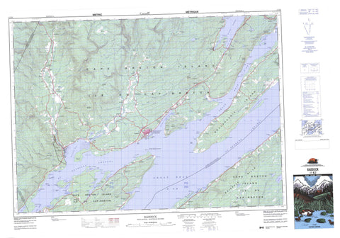
011K02 Baddeck Canada topo map, 1:50,000 scale
011K02 Baddeck NRCAN topographic map.
Includes UTM and GPS geographic coordinates (latitude and longitude). This 50k scale map is suitable for hiking, camping, and exploring, or you could frame it as a wall map.
Printed on-demand using high resolution, on heavy weight and acid free paper, or as an upgrade on a variety of synthetic materials.
Topos available on paper, Waterproof, Poly, or Tyvek. Usually shipping rolled, unless combined with other folded maps in one order.
- Product Number: NRCAN-011K02
- Parent Topo: TOPO-011K
- Map ID also known as: 011K02, 11K2, 11K02
- Unfolded Size: Approximately 26" high by 36" wide
- Weight (paper map): ca. 55 grams
- Map Type: POD NRCAN Topographic Map
- Map Scale: 1:50,000
- Geographical region: Nova Scotia, Canada
Neighboring Maps:
All neighboring Canadian topo maps are available for sale online at 1:50,000 scale.
Purchase the smaller scale map covering this area: Topo-011K
Spatial coverage:
Topo map sheet 011K02 Baddeck covers the following places:
- Back Bay - Baddeck Bay - Baddeck Harbour - Beaver Cove - Big Harbour - Black Cove - Boulaceet Harbour - Campbells Cove - Cow Bay - Deep Cove - Herring Cove - Indian Bay - Indian Cove - Island Point Harbour - John Alex Cove - Maccrutchie Cove - MacDonalds Cove - MacDonalds Cove - MacInnis Cove - MacIvers Cove - MacKenzie Cove - MacNaughtons Cove - MacRitchies Cove - MacRitchies Southside Cove - Malcolms Cove - Martins Cove - Maskells Harbour - Maskell's Harbour - McIvor Cove - Mill Cove - Morrisons Cove - North Gut - Nyanza Bay - Otter Harbour - Oyster Cove - Port Bevis - Rorys Cove - Ross Cove - Seal Cove - Shunacadie Harbour - South Cove - South Cove (Macdonald Cove) - South Gut - St. Ann Harbour - St. Anns Harbour - St. Ann's Harbour - The Harbour - Big Beach - Maclean Beach - Shunacadie Beach - Bevis Point - Birch Point - Black Point - Brian Point - Burnt Point - Cat Point - Coffin Point - Cow Point - Cranberry Point - Cranberry Point - Crow Point - Crow Point - Donald Williams Point - Eagle Hill - Fraser Point - Gillis Point - Green Point - Harbour Point - Island Point - Jeannies Point - Kempt Head - Kid Point - Lockman Point - Longbeach Point - Macdonald Point - MacDonald Point - MacDonalds Point - MacDonalds Point - Macfarlane Point - MacFarlane Point - MacIvers Point - MacKay Point - Mackay Point - Mackenzie Point - MacKenzie Point - MacLean Beach Point - MacLeods Point - MacMillans Point - MacRae Point - Macrae Point - MacRitchies Point - Man of War Point - McIvor Point - McLeod Point - Morris Point - Munro Point - Munroes Point - Murphy Point - Otter Point - Parliament Point - Pinauds Point - Plaster Point - Point Clear - Pony Point - Ponys Point - Pony's Point - Red Head - Red Point - Ross Point - Sandy Point - Seal Point - Sheep Point - Shipyard Point - Squire Point - Sutherland Point - Upper MacLeods Point - Great Bras d'Or - Little Narrows - St. Andrew Channel - St. Andrews Channel - St. Andrew's Channel - St. Patrick Channel - St. Patricks Channel - St. Patrick's Channel - Easach Ban - Cape Breton - Inverness - Juste au Corps - Victoria - Eskasoni 3 - Wagmatcook 1 - Bell Rock Island - Black Island - Bone Island - Boularderie Island - Cape Breton Island - Coffin Island - Double Island - Hume Island - Île du Cap-Breton - Kidston Island - Mathesons Island - Neil Island - Otter Island - Otter Island - Seal Islands - Sheep Island - Spectacle Island - Big Pond Shunacadie - Cains Pond - Camerons Pond - Church Pond - Denas Pond - Lochan Dhu - Loon Lake - Lost Lake - MacEacherns Pond - MacGregors Pond - MacKays Pond - MacKenzie Pond - MacKillops Pond - MacKillops Pond - MacLeods Lake - MacMullins Lake - MacPhedrans Lake - Mathesons Lake - Morrisons Pond - Munroes Lakes - Narrows Pond - Poker Dans Pond - Robenas Pond - Starks Pond - Steeles Lake - Taylors Ponds - Third Lake O'Law - Beinn Bhreagh - Beinn Scalpie - Big Hill - Boisdale Hills - Bras d'Or Lookoff - Cowdis Mountain - Crowdis Mountain - Kellys Mountain - MacMillan Mountain - Northside Mountain - Cape Breton - Inverness - Victoria - Alexander Graham Bell National Historic Site of Canada - Lieu historique national du Canada Alexander-Graham-Bell - Spectacle Island Game Sanctuary - St. Anns Provincial Park - Adelaide Brook - Allans Brook - Angus Farquhars Brook - Baddeck River - Beaver Brook - Bevis Brook - Big Brook - Big Glen Brook - Big Harbour Brook - Black Brook - Buckwheat Brook - Captains Brook - Christopher MacLeod Brook - Christopher McLeod Brook - Dicks Brook - Falls Brook - First Branch Humes River - First Gold Brook - Fox Brook - Foyle Brook - Garry Brook - Gillis Brook - Glen Brook - Gunns Brook - Harris Brook - Hume River - Humes River - Indian Brook - Indian Brook - Indian Brook - Leonard MacLeod Brook - Leonard McLeod Brook - MacAulays Brook - MacDonald Brook - MacDonald Brook - MacDonalds Brook - MacDonalds Brook - MacEacherns Brook - Macintosh Brook - MacIntosh Brook - MacIsaacs Brook - MacIver Brook - MacKay Brook - Mackay Brook - MacKenzie Brook - MacKenzies Brook - MacLean Brook - MacLeods Brook - MacMullin Brook - MacNaughtons Brook - Macneil Brook - MacPhees Brook - MacQuarries Brook - MacRae Brook - MacRae Brook - Marsh Brook - McDonald Brook - McKenzie Brook - McLean Brook - McNaughton Brook - McPhedran Brook - McRae Brook - McRae Brook - Middle River - Mile Brook - Mill Brook - Mill Cove Brook - Mill Creek - Morgan Brook - Morrison Brook - Morrison Brook - Munroes Brook - Murdoch Pauls Brook - Muskrat Brook - New Glen Brook - North Baddeck River - North Branch Baddeck River - North Branch Leonard MacLeod Brook - North Gut Brook - Oyster Creek - Peters Brook - Peters Brook - Rice Brook - Second Branch Humes River - Second Gold Brook - South Haven Brook - Third Branch Humes River - Washabuck River - Bentincks Pool - Big Farm Pool - Forks Pool - Harris Pool - MacDonalds Pool - Nicholsons Pool - Red Bridge Pool - Rice Pool - Bell Rock - Bell Rock - Big Shoal - Burnt Shoal - Coffin Shoal - Eel Shoal - MacIvers Bank - MacPhee Shoal - Macphie Shoal - McIvor Bank - Stony Shoal - Baddeck Bay - Baddeck Bridge - Beaver Cove - Beinn Bhreagh - Beinn Scalpie - Big Baddeck - Big Beach - Big Brook - Big Farm - Big Glen - Big Harbour - Big Hill - Boisdale - Boularderie - Boularderie Centre - Bucklaw - Buckwheat Corner - Crescent Grove - Cross Point - Finlayson - Forks Baddeck - Garry - Gillis Point - Gillis Point East - Glasgow - Glen Tosh - Gold Brook - Goldbrook - Hazeldale - Hume Rear - Humes Rear - Hunters Mountain - Inlet Baddeck - Island Point - Kempt Head - Long Hill - Lower Middle River - Lower Washabuck - MacAulays Hill - MacLeods Point - MacNeils Vale - McAulays - McCharles - McLeod Point - McNeils Vale - Middle River - Middle River Centre - New Glen - New Harris - New Harris Settlement - North Gut St. Anns - North Gut St. Ann's - Nyanza - Peters Brook - Plaister Mines - Port Bevis - Rear Baddeck Bay - Rear Big Hill - Rear Forks - Ross Ferry - Shenacadie - Shunacadie - South Cove - South Gut St. Anns - South Gut St. Ann's - South Haven - South Side of Baddeck River - South Side of Boularderie - St. Anns - St. Patricks Channel - St. Patrick's Channel - Upper Baddeck River - Upper Kempt Head - Upper Middle River - Upper Washabuck - Washabuck Bridge - Washabuck Centre - West Middle River - West Side of Middle River - Yankee Line - Blueberry Barren - Little Barren - Baddeck


