
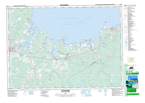
011F12 Antigonish Canada topo map, 1:50,000 scale
011F12 Antigonish NRCAN topographic map.
Includes UTM and GPS geographic coordinates (latitude and longitude). This 50k scale map is suitable for hiking, camping, and exploring, or you could frame it as a wall map.
Printed on-demand using high resolution, on heavy weight and acid free paper, or as an upgrade on a variety of synthetic materials.
Topos available on paper, Waterproof, Poly, or Tyvek. Usually shipping rolled, unless combined with other folded maps in one order.
- Product Number: NRCAN-011F12
- Parent Topo: TOPO-011F
- Map ID also known as: 011F12, 11F12
- Unfolded Size: Approximately 26" high by 36" wide
- Weight (paper map): ca. 55 grams
- Map Type: POD NRCAN Topographic Map
- Map Scale: 1:50,000
- Geographical region: Nova Scotia, Canada
Neighboring Maps:
All neighboring Canadian topo maps are available for sale online at 1:50,000 scale.
Purchase the smaller scale map covering this area: Topo-011F
Spatial coverage:
Topo map sheet 011F12 Antigonish covers the following places:
- Anse des Barges - Antigonish Harbour - Benoits Creek - Church Cove - Church Cove - Condon Cove - Dunns Cove - Frasers Cove - George Bay - Georges Bay - Golfe du Saint-Laurent - Grahams Cove - Grahams Cove - Gulf of St. Lawrence - Havre Bouché - Havre Boucher - Henrys Cove - Jack Dans Cove - Lake Cove - Linwood Harbour - Little Tracadie Harbour - McCalls Cove - Monks Head Harbour - Norries Cove - Placides Cove - Plaster Cove - Pomquet Cove - Pomquet Creek - Pomquet Harbour - Pomquet Road - St. Georges Bay - Taylor Creek - Tracadie Harbour - Tracadie West Arm - Bayfield Beach - Breens Beach - Deloreys Beach - Dunn Beach - Dunns Beach - La Batture - Linwood Beach - Mahoney Beach - Mahoneys Beach - Myettes Beach - Parishs Beach - Pomquet Beach - Rileys Beach - Seabright Beach - West Arm Beach - Archibald Point - Archibalds Point - Arthurs Point - Barrio Head - Barrios Head - Black Point - Bowman Head - Cape Blue - Cape Jack - Colquhoun Point - Dunn Point - Dunns Point - Ferry Point - Grahams Head - Grahams Point - Gregory Point - Gregorys Point - Indians Point - La Pointe - Lukes Point - MacIntoshs Point - MacIsaacs Point - Mackenna Point - McIsaac Point - Middle Head - Monk Head - Monks Head - Pointe à Roche - Pomquet Point - Quarry Point - Town Point - Williams Point - Crystal Cliffs - Dagger Woods - Antigonish - Guysborough - Sydney - Pomquet and Afton 23 - Summerside 38 - Benoit Island - Benoits Island - Big Island - Black Island - Blueberry Island - Captain Island - Captains Island - Crispos Island - Delorey Island - Delory Island - Fallis Island - Flat Island - Gooseberry Island - Grahams Island - Harris Island - Havre Island - Île à Magotte - Île aux Morts - Île du Havre - Isaacs Island - Little Island - Long Island - McCalls Island - Morrell Island - Morrett Island - Myettes Island - Perros Island - Petitpas Island - Pomquet Harbour Island - Pomquet Island - Reef Island - Sheep Island - Terrat Island - Tracadie Big Island - Archies Lake - Ash Lake - Beach Pond - Bordens Lake - Boyds Lake - Boyles Lake - Breens Pond - Cameron Lake - Cape Pond - Captain Pond - Captains Pond - Carls Lake - Clam Harbour Lake - Clancys Pond - Donnellys Lake - Dunphys Lake - Étang La Mélasse - Five Mile Lake - Flynn Lake - Gavins Lakes - Gavin's Lakes - Gillis Lake - Grahams Pond - Guthros Lake - Haleys Lake - Healy Lake - Jacksons Lake - Keys Lake - Laytons Pond - Le Barachois - Leets Lake - Leet's Lake - Little Lake - Macdonald Pond - MacGillivrays Lake - Mackenna Pond - MacLeans Lake - Maynies Lake - Monk Pond - Monks Head Pond - Ogden Pond - Ogdens Pond - Pomquet Lake - Rileys Pond - Rocky Lake - Shepherd Lake - Summers Lake - Tracadie Lake - Wallace Lake - Antigonish - Guysborough - Antigonish Wildlife Management Area - Afton River - Anna Wallaces Brook - Benoit Creek - Black Avon River - Black River - Brierly Brook - Campbells Brook - Chisholms Brook - Colin Chisholm Brook - Dagger Brook - East Branch Tracadie River - Eugenes Brook - Gormans Brook - Havre Bouché Brook - Havre Boucher Brook - Hurlburt Brook - Little Tracadie River - MacDonalds Brook - MacGillivrays Brook - McDonald Brook - McGillivray Brook - McGillivray's Brook - Meadow Bridge Brook - Meadow Brook - Meadows Brook - Meaghers Brook - Millers Brook - Monastery Brook - North Brook - North Intervale Brook - North River - North Tracadie River - Ogden Brook - Ogdens Brook - Orton Brook - Pinevale Brook - Pomquet River - Randalls Brook - Rights River - Roman Valley River - Salt Springs Brook - Silvey Brook - South River - Tates Brook - Tracadie River - Wallace Brook - West Afton River - West Pomquet River - West River - Wrights River - Bowman Bank - Daves Rocks - Jack Shoal - MacIsaacs Rock - McIsaac Rock - McKinleys Ledge - Pomquet Banks - The Bar - The Ledge - Antigonish - Afton - Afton Station - Antigonish Harbour - Antigonish Landing - Barrios Beach - Bayfield - Bayfield Road - Beauly - Beech Hill - Big Tracadie - Black Avon - Black River - Boyd - Brophy - Bucklands - Cape Jack - Cloverville - Croft - Crystal Cliffs - Dagger Woods - Dunmore - East Havre Boucher - East Tracadie - Fairmont - Frankville - Fraser Mills - Frasers Grant - Fraser's Grant - Frasers Mills - Glassburn - Glenroy - Greenwold - Grosvenor - Harbour au Bouche - Harbour Centre - Harbour Road - Havre Bouché - Havre Boucher Station - Heatherton - Jimtown - Lanark - Lincolnville - Linwood - Linwood - Linwood Station - Lower South River - Lower Springfield - Mahoneys Beach - Marydale - Mattie - Mattie Settlement - McPherson - Meadow Green - Merland - Monastery - Monks Head - Morristown - New France - Pinevale - Pitcher Farm - Pitchers Farm - Pomquet - Pomquet Forks - Pomquet Station - Rear Monastery - South Merland - South River Road - South River Station - Southside Antigonish Harbour - St. Andrews - Summerside - Taylor Road - Taylors Road - Tracadie - Upper Afton - Upper Big Tracadie - Upper Pomquet - Vernal - West Arm Tracadie - West Havre Boucher - West Linwood - William Point - Williams Point - Boyds Bog - Frasers Marsh - Pomquet Intervale - The Marsh - Havre Boucher


