
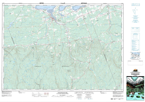
011E11 Tatamagouche Canada topo map, 1:50,000 scale
011E11 Tatamagouche NRCAN topographic map.
Includes UTM and GPS geographic coordinates (latitude and longitude). This 50k scale map is suitable for hiking, camping, and exploring, or you could frame it as a wall map.
Printed on-demand using high resolution, on heavy weight and acid free paper, or as an upgrade on a variety of synthetic materials.
Topos available on paper, Waterproof, Poly, or Tyvek. Usually shipping rolled, unless combined with other folded maps in one order.
- Product Number: NRCAN-011E11
- Parent Topo: TOPO-011E
- Map ID also known as: 011E11, 11E11
- Unfolded Size: Approximately 26" high by 36" wide
- Weight (paper map): ca. 55 grams
- Map Type: POD NRCAN Topographic Map
- Map Scale: 1:50,000
- Geographical region: Nova Scotia, Canada
Neighboring Maps:
All neighboring Canadian topo maps are available for sale online at 1:50,000 scale.
Purchase the smaller scale map covering this area: Topo-011E
Spatial coverage:
Topo map sheet 011E11 Tatamagouche covers the following places:
- Barachois Harbour - Barrachois Harbour - Brule Harbour - Brûlé Harbour - Dobson Creek - Fergusons Cove - Reid Creek - Semple Creek - Tatamagouche Bay - Blockhouse Point - Hingley Point - Sand Point - William Point - The Narrows - Weatherbies Bank - Drysdale Falls - Colchester - Cumberland - Pictou - Seal Island - Steeles Island - Bezansons Lake - Big Snare Lake - Big Totten Lake - Black Lake - Blakeney Lake - Briar Lake - Byers Lake - Byers Ponds - Caribou Pond - Caribou Ponds - Chain Lakes - Clark Lake - Clear Lake - Cook Lake - Cooks Lake - Debert Lake - Earltown Lake - Farm Lake - Frog Lake - Gards Pond - Gully Lake - Gully Lake - Guyon Lake - Indian Lake - Irvine Lake - Island Lake - Johnston Lake - Juniper Lake - Kennedy Lake - Lily Ponds - Little Lake - Little Round Lake - Little Snare Lake - Little Totten Lake - Little Totten Lake - Long Lake - Long Lake - MacIntosh Lake - Mackay Lake - MacKay Lake - MacKinlay Lake - MacRaes Lake - Mattatall Lake - Moose Lake - Musquash Lake - Pine Lake - Rocky Lake - Roodes Pond - Rory Pond - Rorys Pond - Round Lake - Round Lake - Shatter Lake - Silica Lake - Silica Ponds - Taylors Lake - Totten Lake - Trout Lake - Whippey Lake - Whirleywaugh Lake - Cobequid Mountains - Nuttby Mountain - Polson Mountain - Silica Mountain - Spidell Hill - Sugarloaf - Sugarloaf Mountain - Warwick Mountain - Colchester - Cumberland - Pictou - Tatamagouche Provincial Park - Ash Brook - Bailey Brook - Baileys Brook - Bain Brook - Balmoral Brook - Big Caribou River - Biz Brook - Biz Brook - Black Brook - Black Brook - Black River - Black River - Blockhouse Brook - Briar Brook - Byers Brook - Caribou River - Cavanagh Brook - Centre Branch Swan Brook - Chain Lakes Brook - Chambers Brook - Chiganois River - Chiganois River - Coal Mine Brook - Debert River - Dewar River - Diamond Brook - Dobson Creek - Donaldson Mill Brook - Douglas Meadow Brook - East Branch Chiganois River - East Branch Folly River - East Branch River John - East Branch Swan Brook - East Branch Wallace River - East Folly River - East Wallace River - East Wallace River - Falling Brook - Ferguson Brook - Flemming Brook - Fourmile Brook - French River - Gian Brook - Gian Brook - Gouzhore Brook - Gully Brook - Gully Lake Brook - Guyon Brook - Juniper Brook - Long Lake Brook - MacConnell Creek - MacKays Brook - Mackays Mill Brook - MacKays Mill Brook - Matheson Brook - Mattatall Brook - Mattatall Lake Brook - McDonald Brook - McGill Brook - McLeod Brook - Middle Branch North River - Middle Branch of North River - Millard Creek - Miller Brook - Mine Brook - Mine Hole Brook - Munroe Brook - Murray Brook - Nabiscump Brook - North Branch Chiganois River - North River - Old Sams Brook - Pine Brook - Plainfield Brook - Porter Brook - River John - Ross Brook - Salmon River - Shatter Brook - Shatter Lake Brook - Smelt Brook - Smith Brook - South Branch North River - South North River - Steele Run - Sutherland Brook - Swan Brook - Tatamagouche River - Teed Brook - The Brook - Toms Brook - Tom's Brook - Totten Brook - Vamey Brook - Waugh River - Waughs River - West Branch Chiganois River - West Branch North River - West Branch of North River - West Branch River John - West North River - Whirley Brook - White Brook - Yellow Brook - Shatter Lake Stillwaters - Annandale - Balfron - Balmoral Mills - Barrachois - Bayhead - Beacon Hill - Berichan - Bigney - Brook Road - Brule - Brûlé - Brule Corner - Brule Shore - Cavanagh Mills - Central New Annan - Clydesdale - College Grant - Denmark - Diamond - Earltown - East Branch River John - East Earltown - East New Annan - East Wentworth - Fitzpatrick - French River - Kavanaugh Mills - Keble - Keeble - Lake Road - Loganville - Louisville - MacBains Corner - Mattatall Lake - Mattatall Lake - Middleton - Middleton Corner - Mill Brook - Mount Thom - Mountain Road - New Truro Road - North Earltown - Nuttby - Oliver - River John - Sand Point - Sandville - South Loganville - Tatamagouche Mountain - The Falls - Waldegrave - Wallace Grant - Wallace Highlands - Warwick Mountain - Waugh River - Waughs River - Welsford - West Branch River John - West Earltown - West New Annan - West Tatamagouche - Wilson - Bobs Meadow - Juniper Swamp - Sloping Bog - Snare Lake Bogs - Teed Bog - Tatamagouche


