
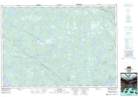
011E01 Liscomb Canada topo map, 1:50,000 scale
011E01 Liscomb NRCAN topographic map.
Includes UTM and GPS geographic coordinates (latitude and longitude). This 50k scale map is suitable for hiking, camping, and exploring, or you could frame it as a wall map.
Printed on-demand using high resolution, on heavy weight and acid free paper, or as an upgrade on a variety of synthetic materials.
Topos available on paper, Waterproof, Poly, or Tyvek. Usually shipping rolled, unless combined with other folded maps in one order.
- Product Number: NRCAN-011E01
- Parent Topo: TOPO-011E
- Map ID also known as: 011E01, 11E1, 11E01
- Unfolded Size: Approximately 26" high by 36" wide
- Weight (paper map): ca. 55 grams
- Map Type: POD NRCAN Topographic Map
- Map Scale: 1:50,000
- Geographical region: Nova Scotia, Canada
Neighboring Maps:
All neighboring Canadian topo maps are available for sale online at 1:50,000 scale.
Purchase the smaller scale map covering this area: Topo-011E
Spatial coverage:
Topo map sheet 011E01 Liscomb covers the following places:
- Carrying Path Cove - Hartlings Cove - Hemloes Cove - Liscomb Harbour - Little Liscomb Harbour - Mitchells Cove - Myers Cove - Northeast Arm - Northwest Arm - Northwest Arm - Pig Cove - Schooner Cove - Scow Cove - Southwest Cove - Spanish Ship Bay - Wilsons Cove - Blind Point - Burnt Head - Clay Head - Fox Point - Hartlan Head - Hartlings Point - Hemloes Point - MacKinlays Point - McKinley Point - Pye Point - Wilson Point - Wilsons Point - The Gut - Gaspereaux Falls - Little River Falls - Rainy Valley Falls - Wilson Falls - Guysborough - Halifax - Marshall Dam - Beach Islands - Charlies Island - Findlay Island - Lang Island - Mouse Island - Pye Island - Pyes Island - Rhodenizers Island - Rileys Island - Rileys Little Island - The Dreadnaught - Anti Dam Flowage - Ash Lake - Ash Lake - Ashton Lake - Barnards Lake - Barneys Lake - Barren Lake - Barren Lake - Barren Lake - Bear Lake - Bear Lake - Bear Lake - Bear Lake - Bent Lake - Bent Lake - Bernard Lake - Big Brook Lake - Big Gaspereau Lake - Big Gaspereaux Lake - Big Liscomb Lake - Bill Neds Lake - Black Brook Lake - Black Lake - Boggy Lake - Boggy Lake - Brent Lake - Bull Moose Lake - Bullrush Lake - Burnt Hill Lake - Calf Moose Lake - Cameron Lakes - Camerons Flowage - Camp Lake - Caribou Pond - Chain Lakes - Charlies Lake - Clam Lake - Clarkes Lakes - Cranberry Lake - Cranberry Lake - Cranberry Lakes - Crane Lake - Cross Lake - Dan Lake - Denis Lakes - Devil Lake - Devils Lake - Dipper Lake - Dog Lake - East Branch Mud Lake - East Lake - East River Lake - East River Sheet Harbour (Reservoir) - East Sinclair Lake - Eastern Hill Lake - Fancys Hill Lake - First Lake - First Lake - Fitz Lake - Fourth Lake - Francis Gut Lake - Fritz Lake - Gegogan Lake - George Lake - Granite Lake - Grassy Lake - Grassy Lake - Grassy Lake - Grassy Lake - Green Lake - Gregwell Lake - Hardwood Lake - Head Lakes - Hooper Lake - Hot Lake - Hungry Lake - Hunting Lake - Irving Lake - Island Lake - Joe Lake - Jordan Lake - Juniper Lake - Kelly Lake - Kelly Lake - Kennies Lake - Kindervater Lake - Kirby Lake - Ladle Lake - Laura Lake - Lindsay Pond - Liscomb Lake - Little Joe Lake - Little Liscomb Lake - Little Rocky Lake - Little Rocky Lake - Lone Clouds Lake - Long Lake - Long Lake - Long Lake - Long Lake - Long Lake - Long Lakes - Long Marsh Lake - Lost Lake - Louse Lake - Lower Caribou Pond - Lower Gaspereau Lake - Lower Gaspereaux Lake - Lower Rocky Lake - Malay Lake - Marshall Flowage - Mary Lake - Marys Lake - Mattiowl Lake - McCarthy Lake - McIntosh Lake - McPhail Lake - Melopseketch Lake - Metkiff Lake - Middle Lake - Mill Brook Lake - Miller Lake - Mitchell Lake - Mitchell Lake - Mitchells Lake - Mitchells Pool - Mohawk Lake - Moose Lake - Moose Lake - Morris Lake - Moser Lake - Mountain Lake - Mud Lake - Muskrat Lake - Neverfail Pond - North Brook Lake - North Lake - Northwest Arm Lake - Northwest Lake - Oak Hill Lake - Oak Lake - Otter Lake - Otter Lake - Otter Lake - Outside Cranberry Lake - Poison Lake - Prince Arthur Lake - Pug Hole - Quoddy Lake - Rabbit Lake - Rainbow Lake - Robertson Lake - Rock Island Lake - Rocky Lake - Rocky Lake - Rocky Lake - Ross Lake - Round Lake - Round Lake - Round Lake - Round Lake - Rush Lake - Rush Lake - Second Lake - Second Lake - Second Lake - Seloam Lake - Shingle Lake - Shoaly Lake - Shoe Lake - Silver Pond - Sinclair Lake - Sinclair Lake - Sloane Lake - Slough Lake - Smith Lake - Smith Lake - Smith Lake - Snows Lake - South Arm Lake - Spar Lake - Spider Lake - Square Lake - Square Lake - Sutherlands Lake - Tee Lake - The Gullies - Three Island Lake - Toadfish Lakes - Tom Lake - Trout Lake - Twin Lakes - Twin Lakes - Twin Lakes - Typhus Lake - Upper Rocky Lake - Weirs Pond - West Lake - West River Lake - West Sinclair Lake - West Slough Lake - Whidden Lake - White Lake - Widden Lake - Yankee Lake - Bakers Hill - Beech Hill - Blackberry Hill - Cochrane Hill - Eastern Hill - Flat Beech Hill - Gisborne Hill - Hackmatack Hill - Lookout Hill - Marys Hill - Oak Hill - Rudolphs Hill - The Mount - Halifax - St. Mary's - Judds Pool Provincial Park - Liscomb Game Sanctuary - Liscomb River Wilderness Area - Archie Rips - Ash Rips - Big Eddy - Devils Eddy - Glencross Rips - Indian Rips - Little Eddy - Rainy Valley Rapids - The Keyhole - The Runaround - Barkhill Brook - Barkhill Brook - Bass Run - Bear Brook - Big Brook - Black Brook - Burnt Hill Lake Brook - Burnt Lake Brook - Churn Brook - Creighton Brook - Crooked Brook - East Barkhill Brook - East Branch Salmon River - East Brook - East Brook - East River - East River Sheet Harbour - East River Sheet Harbour - Eastern Hill Brook - Ecum Secum River - Fifteen Mile Stream - Fifteen-mile Stream - Francis Gut - Fraser Brook - Frasers Gully - Gaspereau Brook - Gaspereaux Brook - Gegogan Brook - George Brook - Golden Fleece Brook - Hardwood Brook - Hardwood Lake Brook - Hooper Brook - Island Brook - Joe Brook - John MacIntoshs Brook - Jordan Brook - Kelly Brook - Lake Mine Brook - Liscomb River - Little Liscomb River - Long Lake Brook - Long Lakes Brook - MacQuarries Brook - McDonald Mill Brook - McQuarrie Brook - Melopseketch River - Metkiff Mill Brook - Mill Brook - Miller Lake Brook - Mines Branch - Mitchell Brook - Moose Lake Brook - Moser River - Mulgrave River - Mullen Mill Brook - North Brook - Northeast Brook - Northeast Salmon River - Northwest Arm Brook - Otter Brook - Otter Brook - Palmer Brook - Pye Brook - Quoddy River - Rabbit Brook - Rabbit Lake Brook - Rabbit Plain Brook - Rabbit Plane Brook - Salmon River - Seven Mile Stream - Seven-mile Stream - Silver Pond Brook - Sinclair Brook - Slate Brook - Smith Brook - Spanish Ship Bay Brook - St. Mary River - St. Marys River - St. Mary's River - The Runaround Brook - The Run-around Brook - Trout Brook - Trout Lake Brook - West Branch Salmon River - West Brook - West Brook - Beaver Hole - Big Stillwater - Burnt Dam Stillwater - Corkum Stillwater - Cottage Pool - Crows Nest Pool - Fourth Lake Stillwaters - Graveyard Pool - John Lowe Stillwaters - Jordan Stillwaters - Juds Pool - Lily Pool - Line Pool - Lynds Pool - MacIntosh Deadwater - Marsh Stillwater - Melopseketch Stillwater - Moose Bog Stillwater - Moosehorn Pool - Mount Pool - Otter Stillwater - Salmon Hole - Skunk Hole - Snows Pool - Spinney Deadwater - The Forks - Veinotte Deadwater - Wrights Dam Pool - George Pyes Shoal - Hen Ledge - Rhodenizers Reef - Wilsons Shoal - Cochrane Hill - Crows Nest - Crow's Nest - Goldenville - Liscomb - Liscomb Mills - Lochaber Mines - New Chester - Spanish Ship Bay - Waternish - Wilson Cove - Wilsons Cove - Diamond Valley - Alder Ground - Big Yellow Bog - Boot Jack Bog - Cranberry Bog - MacCarthys Bog - Moose Bog - Quoddy Bog - Rabbit Plain Bog - Smith Bog - The Big Bog


