
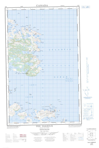
003D05E Fox Harbour Canada topo map, 1:50,000 scale
003D05E Fox Harbour NRCAN topographic map.
Includes UTM and GPS geographic coordinates (latitude and longitude). This 50k scale map is suitable for hiking, camping, and exploring, or you could frame it as a wall map.
Printed on-demand using high resolution, on heavy weight and acid free paper, or as an upgrade on a variety of synthetic materials.
Topos available on paper, Waterproof, Poly, or Tyvek. Usually shipping rolled, unless combined with other folded maps in one order.
- Halfsheet: This map was designed as a half sheet of NRCAN-003D05, and it is the Eastern half. Find the western half sheet here.
- Product Number: NRCAN-003D05E
- Parent Topo: TOPO-003D
- Map ID also known as: 003D05, 03D5, 3D5, 03D05, 3D05
- Unfolded Size: Approximately 26" high by 36" wide
- Weight (paper map): ca. 55 grams
- Map Type: POD NRCAN Topographic Map
- Map Scale: 1:50,000
- Geographical region: Newfoundland and Labrador, Canada
Neighboring Maps:
All neighboring Canadian topo maps are available for sale online at 1:50,000 scale.
Purchase the smaller scale map covering this area: Topo-003D
Spatial coverage:
Topo map sheet 003D05E Fox Harbour covers the following places:
- Aaron Cove - Alexis Bay - Assizes Harbour - Back Cove - Back Harbour - Barren Bay - Battle Harbour - Beachy Cove - Benjy's Cove - Bottom Arm - Bruce Cove - Canvas Cove - Capstan Cove - Caribou Cove - Cartridge Bight - Cartwright Bight - Charlotte Harbour - Crow Bay - Deadrick Cove - Deep Cove - Deepwater Creek Cove - Deer Cove - Deer Harbour - Drunken Cove - Duck Island Harbour - Effingham Harbour - False Cove - Fenchman Cove - Fox Harbour - Foxburrow Cove - Frenchman Cove - Gin Cove - Green Cove - Green Cove - Green Cove - Green Cove - Hatters Cove - Hauling Cove - Hogan Cove - Hoop-pole Cove - Hopkins Cove - Hudson Cove - Indian Cove - Johnny Mews Cove - Kyer Cove - Little Harbour - Little Spear Harbour - Long Harbour - Lord and Lady Gulch - Man of War Cove - Man of War Cove - Man of War Harbour - Mary's Harbour - Matthews Cove - Mecklenburg Harbour - Mosquito Cove - Muddy Cove - Murray Harbour - Neds Harbour - North Arm - Northeast Cove - Petty Harbour - Pommelly Cove - Port Charlotte - Port Marnham - Rumbolts Cove - Salmon Bight - SaltPond - Sand Cove - Sealing Bight - Ship Harbour - Ships Harbour - Shoal Cove - Sophia Harbour - Spear Harbour - St. Lewis Inlet - Tarfers Cove - The Lodge - Timothys Creek - Trap Cove - Trap Cove - Twelve O'clock Harbour - West Arm - Western Cove - Wolf Cove - Bay Point - Bear Cove Head - Black Head - Black Point - Brownies Path (Neck) - Burnt Point - Cape St. Lewis - Caribou Point - Carrscove Point - Club Cape - Crow Bay Head - Crowby Head - Danger Point - Deadrick Point - Deer Point - Drunken Cove Point - Farmers Point - Fergus Head - Fishermen Point - Foxburrow Point - Gunning Point - Hatters Point - Island Point - Kyer Cove Point - Level Point - Lion's Head - Lower Shoal Cove Head - Man of War Point - Marley Point - Marleys Point - Mary's Harbour Head - Northern Head - Pommelly Cove Point - Ragged Point - Rock Point - Round Head - Salmon Bight Point - Salmon Point - Salt Pond Head - Seal Rock Point - Shoal Cove Head - Shoal Point - Shoal Point - Shoal Point - Southern Head - Spear Point - Tarfers Point - Tilcey Point - Twelve O'clock Head - Captain Jack's Tickle - Caribou Run - Crow Rock Tickle - Dark Tickle - Double Island Tickle - Eastern Tickle - Farmers Gulch - Gull Island Tickle - GunningTickle - Lamb Tickle - Mikes Tickle - Mouse Island Tickle - Nimrod Tickle - Red Island Tickle - Shoal Tickle - Southern Tickle - St. Lewis Sound - Aaron Island - American Island - Anthony Islands - Assizes Island - Bard Island - Battle Island - Battle Islands - Captain Jack's Island - Chapel Island - Copper Island - Crow Island - Daddy Island - Double Island - Double Islands - Duck Island - Duck Island - Fish Island - Flat Island - Goose Island - Grassy Island - Great Caribou Island - Great Island - Green Island - Green Island - Gull Island - Gunning Island - Harbour Island - Hare Island - Herringnet Island - High Island - Humphrey Island - Indian Island - Jack Fling Island - Killick Island - Marnham Island - Motion Island - Mountain Cat Islands - Mouse Island - Pigeon Islands - Red Island - River Islands - Road Island - Salmon Rock - Ships Harbour Island - Shoal Cove Island - Snooks Island - Soldier Island - Southern Island - West Island - Big Steady - Black Hill Pond - Black Hill Second Pond - Black Hill Third Pond - Blue Hill Pond - Bradleys Ponds - Carbons Pond - Creek Long Pond - Creek Pond - Daddys Island Steady - Deer Harbour Ponds - Deer Island Ponds - Felthams Pond - Fifty Islands Pond - Fox Harbour Pond - Freshwater Pond - Guys Pond - Hawk Nest Pond - Komatik Path Pond - Long Pond - Long Pond - Long Steady - Mungo Pond - Muskrat Pond - Otter Pond - Round Hill Pond - Russells Pond - Saltwater Pond - Saltwater Pond - Sheer Gulch Ponds - Ships Harbour Pond - Shoal Point Pond - Spring Pond - Tom Hammonds Pond - Trap Cove Pond - Tub Harbour Pond - Birchy Hill - Black Hill - Blue Hills - Burchey Hill - Deer Harbour Ridge - Round Hill - Deepwater Creek - Hatters Cove Brook - Salt Brook - St. Marys River - Labrador Sea - Mer du Labrador - Assizes Rock - Black Rock - Black Rock - Black Rock - Blake Ground - Cannon Rock - Caribou Bank - Chapel Island Rock - Cutlers Rock - Double Island Bank - Eskimo Bank - Fling Bank - Green Island Bank - Greenfield Shoal - Gull Rock - Gull Rock - Gull Rocks - Gun Rock Shoal - Gunning Rock - Hussey Shoal - Little Cannon - Mad Moll - Mad Moll Rock - Mags Rocks - Marley Rocks - Martin Bank - Mid Rock - Middle Rib - Middle Rocks - Monday Bank - Motion Rocks - Nimrod Shoal - North Rib - Northern Bank - Offer Bank - Parsons Ground - Red Island Rock - Shag Rocks - Skinner Ledge - Smiths Rock - Soldier Shoal - South Rib - Southern Bank - Southern Island Rock - St. Lewis Rock - The Bull - The Flats - The Pig - The Rags - The Scab - The Wall - Tinker Bank - Mary's Harbour - St. Lewis - Battle Harbour - Caribou Run - Indian Cove (settlement) - Petty Harbour - Seal Bight - Spear Harbour - Bear Gulch - Ragged Gulch - Fox Harbour


