
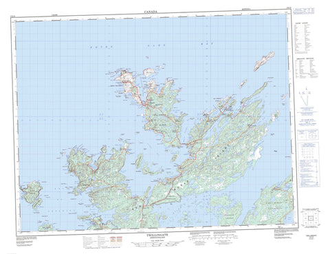
002E10 Twillingate Canada topo map, 1:50,000 scale
002E10 Twillingate NRCAN topographic map.
Includes UTM and GPS geographic coordinates (latitude and longitude). This 50k scale map is suitable for hiking, camping, and exploring, or you could frame it as a wall map.
Printed on-demand using high resolution, on heavy weight and acid free paper, or as an upgrade on a variety of synthetic materials.
Topos available on paper, Waterproof, Poly, or Tyvek. Usually shipping rolled, unless combined with other folded maps in one order.
- Product Number: NRCAN-002E10
- Parent Topo: TOPO-002E
- Map ID also known as: 002E10, 02E10, 2E10
- Unfolded Size: Approximately 26" high by 36" wide
- Weight (paper map): ca. 55 grams
- Map Type: POD NRCAN Topographic Map
- Map Scale: 1:50,000
- Geographical region: Newfoundland and Labrador, Canada
Neighboring Maps:
All neighboring Canadian topo maps are available for sale online at 1:50,000 scale.
Purchase the smaller scale map covering this area: Topo-002E
Spatial coverage:
Topo map sheet 002E10 Twillingate covers the following places:
- Back Harbour - Bay of Exploits - Beachy Cove - Beachy Cove - Bear Cove - Beaver Cove - Black Island Harbour - Bluff Head Cove - Bridgeport Harbour - Bridger Cove - Browneys Cove - Burnt Arm - Byrne Cove - Carter's Cove - Cat Cove - Chanceport Harbour - Chimney Cove - Chockin Cove - Clarkes Cove - Cobbs Arm - Codjack Cove - Connert Head Cove - Cottle's Bay - Cross Cove - Davy Button Cove - Devils Cove - Dog Bay - Dumpling Cove - Durrell Arm - Farmers Arm - Fools Harbour - Friday Bay - Gallows Cove - Gillott Cove - Goshens Arm - Gut Arm - Herring Cove - Horwood Bay - Indian Cove - Jenkins Cove - Jenkins Cove - Kiar Cove - Kiddle Cove - Little Beaver Cove - Little Bridgeport Harbour - Little Byrne Cove - Little Harbour - Little Harbour Bight - Little Wild Cove - Lobster Harbour - Luke's Arm - Manuel Cove - Manuels Cove - Milliners Arm - Moreton's Harbour - Morton Cove - Mudford Cove - Ninepin Arm - Old House Cove - Parsons Cove - Pearce Harbour - Pikes Arm - Pomley Cove - Potash Cove - Puzzle Bay - Puzzle Harbour - Robins Cove - Rodney Cove - Roses Harbour - Rushy Cove - Saffron Cove - Salt Harbour - Sam Cove - Sam Jeans Cove - Sealing Cove - Sleepy Cove - Southern Harbour - Spillers Cove - Squid Cove - Starve Harbour - Tilt Cove - Tizzard's Harbour - Toogood Arm - Twillingate Harbour - Upper Gut Arm - Virgin Arm - Webber Bight - Western Head Cove - Wild Bight - Wild Cove - Great French Beach - Long Beach - Back Harbour Head - Beaver Head - Black Point - Bluff Head - Bread and Butter Point - Bridgeport Harbour Head - Burns Point - Carter Head - Carters Head - Clam Rock Head - Coddle Point - Crow Head - Cuckold Point - Deepwater Point - Devils Cove Head - Dicky Head - Dumpling Point - East Crow Head - East Point - French Head - Gunning Head - Handkerchief Cove Head - Hell Grapple Head - Hell-mouth Head - Herring Head - Herring Neck - Horney Head - Long Point - Lower Head - Moreton's Harbour Head - Moses Point - Muddy Hole Point - Old House Cove Head - Pearce Harbour Point - Port Albert Peninsula - Puzzle Harbour Head - Ragged Point - Rose Head - Round Head - Spillers Point - Starve Head - Tickle Point - Tizzard's Harbour Head - Western Head - Wild Bight Head - Wild Point - Young Point - Black Island Tickle - Burnt Island Tickle - Gut Tickle - Herring Head Tickle - Long Tickle - Main Tickle - Shoal Tickle - The Pinnacle - Anderson Island - Bacalhao Island - Back Harbour Gull Island - Batrix Island - Berry Island - Berry Island - Big Gull Island - Black Island - Black Island - Brandies - Bridgeport Island - Burnt Island - Chance Harbour Island - Christopher Island - Cottle's Island - Cottle's Storehouse Island - Crow Head Island - Currant Islands - Dog Island - Dram Island - Duck Island - Duck Island - Duck Islands - Dunnage Island - Fish Island - Fools Harbour Islands - Fudges Island - Goose Island - Gooseberry Island - Grassy Islands - Green Island - Gull Island - Hamilton Island - Harts Island - Herring Islands - Higgins Island - Hose Island - Indian Garden Island - Jack's Island - Joe Island - Killick Stone Island - Knowles Island - Little Black Island - Little Gull Island - Main Tickle Island - Matthews Island - Mouse Island - Neal Island - New World Island - North Trump Island - North Twillingate Island - Pomley Cove Gull Island - Pond Island - Rags Island - Red Island - Red Island - Salt Harbour Island - Ship Island - Sleepy Cove Gull Island - South Berry Island - South Trump Island - South Twillingate Island - Storehouse Island - Tilt Cove Island - Tinker Island - Trump Islands - Welsh Island - Moses Pond - Rushy Cove Pond - Salt Pond - Saltwater Pond - Stockeys Pond - Tom Jenkins Pond - White Pilot Basin - Wild Pond - Bald Hills - Bearberry Hill - Eastern Hill - North West Lookout - Smith Lookout - Styles Hill - The Nuddick - Tom Tumbler Hill - White Hills - Dildo Run Provincial Park - Dildo Run - Rushy Cove River - Baker Rock - Baldney Rock - Berg Rock - Berry Island Rock - Black Rock - Black Rocks - Blake Rock - Blowhard Rock - Bradley Rock - Brandies Rock - Bread-box - Bridgeport Rock - Burnt Island Rocks - Carter Head Rock - Cheeky Rocks - Copper Rock - Crow Rock - Cuckold Rocks - Dram Rock - East Rocks - Eastern Grounds - Eel Bank - Field Shoal - French Rock - Friday Ledge - Fudge Ground - Gull Island Rock - Gull Rock Bank - Gunning Rock - Harbour Rock - Harper Ledge - Hatchet Rocks - Haypook Rocks - Hell Alley - High Shag Rock - Hussey Rock - Jim Rock - Joe Penny Banks - Killick Shoal - Lawrence Ledge - Low Shag Rock - Mad Moll Rock - Manifold Rock - Mann Rocks - Millers Rock - Moreton's Harbour Rocks - Morris Rock - Mouse Rock - Nine Foot Rock - Nippers Ledge - North East Rock - Northern Ground - Offer Ground - Offer Rock - Offer Western Ground - Old Harry - Old Roger - Old Roger Reef - Old Rusty - Parky Rock - Pearce Ground - Pearce Rock - Primer - Puzzle Harbour Rocks - Red Point Ground - Red Rock - Red Rock - Round Head Rock - Russel Rock - Sculpin Ledge - Serpent Tail - Shackle Bank - Shag Rock - Shag Roost - Shoal Rock - Skinners Ground - Smoker Ledge - Southwest Shoal - Sunker Rock - The Baker - Toadasses - Tom Cod Rock - Tuesday Ledge - West Rock - West Shag Rock - Western Ground - Whale Back Rock - White Ground - White Ground - White Rock - White Shoal - Wild Cove Rocks - Young Harry - Young Roger - Cottlesville - Crow Head - Summerford - Twillingate - Back Harbour - Bayview - Beaverton - Black Duck Cove - Black Island - Black Island - Bluff Head Cove - Bridgeport - Burnt Cove - Carter's Cove - Chanceport - Cobbs Arm - Cobb's Arm - Cottle's Island - Cottle's Island-Luke's Arm - Cottlesville - Durrell - Fairbank - Fairbanks - Fairbanks East - Fairbanks-Hillgrade - Gillard's Cove - Gillesport - Green Cove - Hatchet Harbour - Hayward Cove - Herring Neck - Hillgrade - Indian Cove - Jenkins Cove - Kettle Cove - Little Harbour - Little Harbour - Lobster Harbour - Luke's Arm - Manuels Cove - Manuel's Cove - Manuel's Cove-Gillard's Cove - Merritts Harbour - Merritt's Harbour - Moreton's Harbour - Newville - Paradise - Parkview - Pikes Arm - Port Albert - Purcell Harbour - Purcell's Harbour - Salt Harbour - Salt Pans - Ship Island - Smooth Cove - Sunnyside - Tilt Cove - Tizzard's Harbour - Toogood Arm - Trump Islands - Twillingate - Valley Pond - Virgin Arm - Virgin Arm-Carter's Cove - Western Head - Whale Gulch - Whale's Gulch - Wild Cove - Bear Gulch


