Antarctica Satellite, Laminated by National Geographic Maps
Click to Zoom (high resolution)
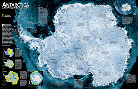
A striking view of Antarcticas terrain, compiled from 4,500 satellite scans. Additional inset maps show surface elevation, ice sheet thickness, velocity of ice flow, and sea ice movement and windflow.
The map is encapsulated in heavy-duty 1.6 mil laminate which makes the paper much more durable and resistant to the swelling and shrinking caused by changes in humidity. Laminated maps can be framed without the need for glass.
- Product Number: 2165576M
- Product Code: NG_ANT_LAM
- Publisher Product ID: RE00620144
- ISBN: 9780792250128
- Year of Publication: 2010
- Unfolded Size: 22.83 x 29.53 inches
- Map type: Wall Map
- Geographical region: Antarctica