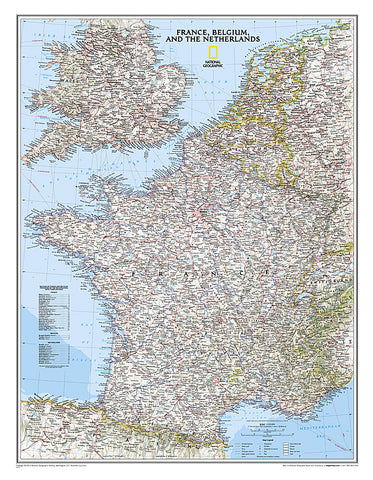
France, Belgium, Netherlands, Classic, Political by National Geographic Maps
National Geographics Classic style political map of France, Belgium, and The Netherlands features clearly defined international boundaries, thousands of place names, waterbodies, airports, major highways and roads, national parks, and much more. Also shown are the regions updated infrastructures, including major oil fields and pipelines; high-speed passenger railway lines; canals; and ferry routes. The tasteful color palette, shaded relief, and bathymetric data make this map as attractive as it is functional. Luxembourg and portions of the United Kingdom, Germany, Switzerland, Spain, and Italy are shown as well.
The map is packaged in a 2-diameter clear plastic tube. The tube has a decorative label showing a thumbnail of the map with dimensions and other pertinent information.
- Product Number: 2030820M
- Product Code: NG_F_WA
- Publisher Product ID: RE0622074T
- ISBN: 9780792249658
- Year of Publication: 2014
- Unfolded Size: 27.56 x 20.47 inches
- Map type: Wall Map
- Geographical region: France