
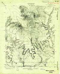
~ Warm Creek UT topo map, 1:63360 scale, 15 X 15 Minute, Historical, 1922
Warm Creek, Utah, USGS topographic map dated 1922.
Includes geographic coordinates (latitude and longitude). This topographic map is suitable for hiking, camping, and exploring, or framing it as a wall map.
Printed on-demand using high resolution imagery, on heavy weight and acid free paper, or alternatively on a variety of synthetic materials.
Topos available on paper, Waterproof, Poly, or Tyvek. Usually shipping rolled, unless combined with other folded maps in one order.
- Product Number: USGS-5680185
- Free digital map download (high-resolution, GeoPDF): Warm Creek, Utah (file size: 7 MB)
- Map Size: please refer to the dimensions of the GeoPDF map above
- Weight (paper map): ca. 55 grams
- Map Type: POD USGS Topographic Map
- Map Series: HTMC
- Map Verison: Historical
- Cell ID: 54941
- Scan ID: 252650
- Survey Year: 1922
- Datum: Unstated
- Map Projection: Unstated
- Map published by United States Geological Survey
- Keywords: Nonstandard Press Run
- Map Language: English
- Scanner Resolution: 600 dpi
- Map Cell Name: Gunsight Butte
- Grid size: 15 X 15 Minute
- Date on map: 1922
- Map Scale: 1:63360
- Geographical region: Utah, United States
Neighboring Maps:
All neighboring USGS topo maps are available for sale online at a variety of scales.
Spatial coverage:
Topo map Warm Creek, Utah, covers the geographical area associated the following places:
- Prickly Pear Point - Cookie Jar Butte - Mystery Canyon (historical) - The Sand Hills - Cottonwood Wash - Pasture Point - Padre Creek - Left Fork Chynoweth Canyon - Romana Bench - Right Fork Kane Wash - Gunsight Spring - Little Alstrom Point - Romana Mesa - Warm Creek Bay - Sile Brink Hollow - Labyrinth Bay - Padre Point - Wahweap Window - Gunsight Pass - Alstrom Point - Gunsight Canyon - Gunsight Tank - Padre Bay - Warm Creek - Crossing of the Fathers (historical) - Face Canyon (historical) - Kelly Grade - Dewey Seep - Spanish Trail Crossing at Warm Creek (historical) - Padres Butte - Croton Canyon - Sit Down Bench - Crosby Canyon - Kane Point - Left Fork Kane Wash - Wahweap Bay - Croton Bench - Wagon Box Canyon - Oley Knolls - Padre Tank - Berry Springs - Dominguez Butte - Center Fork Kane Wash - Squaw Canyon - Last Chance Creek - West Sit Down Bench - Padre Canyon - Point of the Mountain Tank - Kane Wash (historical) - Gunsight Butte - Powell Camps (historical) - Pasture Point Canyon - White Rocks - Little Valley Canyon - Gunsight Bar - Smoky Hollow - Gunsight Bay - Labyrinth Bay - Last Chance Bay - Warm Creek Cabins (historical) - Smoky Mountain - Castle Rock
- Map Area ID: AREA37.2537-111.5-111.25
- Northwest corner Lat/Long code: USGSNW37.25-111.5
- Northeast corner Lat/Long code: USGSNE37.25-111.25
- Southwest corner Lat/Long code: USGSSW37-111.5
- Southeast corner Lat/Long code: USGSSE37-111.25
- Northern map edge Latitude: 37.25
- Southern map edge Latitude: 37
- Western map edge Longitude: -111.5
- Eastern map edge Longitude: -111.25


