
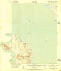
~ Antelope Island North UT topo map, 1:24000 scale, 7.5 X 7.5 Minute, Historical, 1954, updated 1956
Antelope Island North, Utah, USGS topographic map dated 1954.
Includes geographic coordinates (latitude and longitude). This topographic map is suitable for hiking, camping, and exploring, or framing it as a wall map.
Printed on-demand using high resolution imagery, on heavy weight and acid free paper, or alternatively on a variety of synthetic materials.
Topos available on paper, Waterproof, Poly, or Tyvek. Usually shipping rolled, unless combined with other folded maps in one order.
- Product Number: USGS-5677702
- Free digital map download (high-resolution, GeoPDF): Antelope Island North, Utah (file size: 8 MB)
- Map Size: please refer to the dimensions of the GeoPDF map above
- Weight (paper map): ca. 55 grams
- Map Type: POD USGS Topographic Map
- Map Series: HTMC
- Map Verison: Historical
- Cell ID: 1141
- Scan ID: 247919
- Imprint Year: 1956
- Aerial Photo Year: 1950
- Field Check Year: 1954
- Datum: NAD27
- Map Projection: Polyconic
- Map published by United States Geological Survey
- Map published by United States Army Corps of Engineers
- Keywords: Overedge
- Map Language: English
- Scanner Resolution: 600 dpi
- Map Cell Name: Antelope Island North
- Grid size: 7.5 X 7.5 Minute
- Date on map: 1954
- Map Scale: 1:24000
- Geographical region: Utah, United States
Neighboring Maps:
All neighboring USGS topo maps are available for sale online at a variety of scales.
Spatial coverage:
Topo map Antelope Island North, Utah, covers the geographical area associated the following places:
- Great Salt Lake State Park - Antelope Island Army Ranger and Air Force Memorial - Payne Field (historical) - Antelope Island Campground - Beacon Knob - Ladyfinger Springs - Ladyfinger - North Davis Division - White Rock Bay - Howard Slough Waterfowl Management Area - Buffalo Bay - Tin Lambing Shed Basin - Camera Flats
- Map Area ID: AREA41.12541-112.25-112.125
- Northwest corner Lat/Long code: USGSNW41.125-112.25
- Northeast corner Lat/Long code: USGSNE41.125-112.125
- Southwest corner Lat/Long code: USGSSW41-112.25
- Southeast corner Lat/Long code: USGSSE41-112.125
- Northern map edge Latitude: 41.125
- Southern map edge Latitude: 41
- Western map edge Longitude: -112.25
- Eastern map edge Longitude: -112.125


