
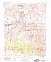
~ The Needles UT topo map, 1:62500 scale, 15 X 15 Minute, Historical, 1953, updated 1970
The Needles, Utah, USGS topographic map dated 1953.
Includes geographic coordinates (latitude and longitude). This topographic map is suitable for hiking, camping, and exploring, or framing it as a wall map.
Printed on-demand using high resolution imagery, on heavy weight and acid free paper, or alternatively on a variety of synthetic materials.
Topos available on paper, Waterproof, Poly, or Tyvek. Usually shipping rolled, unless combined with other folded maps in one order.
- Product Number: USGS-5462959
- Free digital map download (high-resolution, GeoPDF): The Needles, Utah (file size: 9 MB)
- Map Size: please refer to the dimensions of the GeoPDF map above
- Weight (paper map): ca. 55 grams
- Map Type: POD USGS Topographic Map
- Map Series: HTMC
- Map Verison: Historical
- Cell ID: 63500
- Scan ID: 252344
- Imprint Year: 1970
- Woodland Tint: Yes
- Aerial Photo Year: 1953
- Edit Year: 1969
- Field Check Year: 1953
- Datum: NAD27
- Map Projection: Polyconic
- Map published by United States Geological Survey
- Map Language: English
- Scanner Resolution: 600 dpi
- Map Cell Name: The Needles
- Grid size: 15 X 15 Minute
- Date on map: 1953
- Map Scale: 1:62500
- Geographical region: Utah, United States
Neighboring Maps:
All neighboring USGS topo maps are available for sale online at a variety of scales.
Spatial coverage:
Topo map The Needles, Utah, covers the geographical area associated the following places:
- Lower Red Lake Canyon - Thieves Cache Arch - Shot Canyon - Cross Canyon - Red Lake Canyon - The Slide - Butler Wash - Jasper Canyon - Salt Creek - West Fork Twin Canyon - Kissing Cows - Devils Canyon - The Doll House - Chesler Canyon - Petes Mesa - The Confluence - The Needles Ranger Station - Cyclone Canyon - Roadside Ruin - Druid Arch - The Needles Canyon - Little Spring Canyon - Sin-av-to-weap - Devils Pocket - The Needles Country - Upper Red Lake - Elephant Hill - Chimney Rock - Canyonlands National Park - Butler Flat - The Grabens - Deep Canyon - Jasper Canyon - Angel Arch - Calamity Mesa - Suprise Valley - Water Canyon - Virginia Park - Silver Stairs - Land of Standing Rocks - Kirk Fence - Wooden Shoe - Cow Canyon - Soda Spring - Cave Spring - Peekaboo Spring - Canyonlands National Park Needles Fire District - Trail Arch - The Doll House - Pothole Point - Twin Valleys - The Needles - Devils Pocket - Deep Canyon - Twin Canyon - Chocolate Drops - Squaw Spring - Chesler Park - Horsehoof Arch - Peekaboo Spring - North Flat - Chocolate Drops - West Fork Salt Creek - Joint Trail - Squaw Flat Campground - Beehive Arch - Lost Canyon - Pappys Pasture - Soda Spring - Spanish Bottom - Cave Spring Trail - Shot Canyon - Bobbys Hole - Stillwater Canyon - Standing Rock - Devils Lane - Green River - Rim View - Squaw Butte - Land of Standing Rocks - Water Canyon - Lens Canyon - Ruin Park - S.O.B. Hill - Pappys Pasture - Colorado River Overlook - Confluence Overlook - The Loop - Meander Canyon - Elephant Canyon - Y Canyon - Muffin Arch - Aztec Canyon - The Grabens - Land of Standing Rocks - Main Flat - Upper Jump - Cave Cliff - Lower Jump - Squaw Flat
- Map Area ID: AREA38.2538-110-109.75
- Northwest corner Lat/Long code: USGSNW38.25-110
- Northeast corner Lat/Long code: USGSNE38.25-109.75
- Southwest corner Lat/Long code: USGSSW38-110
- Southeast corner Lat/Long code: USGSSE38-109.75
- Northern map edge Latitude: 38.25
- Southern map edge Latitude: 38
- Western map edge Longitude: -110
- Eastern map edge Longitude: -109.75


