
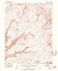
~ The Knoll UT topo map, 1:62500 scale, 15 X 15 Minute, Historical, 1951, updated 1953
The Knoll, Utah, USGS topographic map dated 1951.
Includes geographic coordinates (latitude and longitude). This topographic map is suitable for hiking, camping, and exploring, or framing it as a wall map.
Printed on-demand using high resolution imagery, on heavy weight and acid free paper, or alternatively on a variety of synthetic materials.
Topos available on paper, Waterproof, Poly, or Tyvek. Usually shipping rolled, unless combined with other folded maps in one order.
- Product Number: USGS-5462943
- Free digital map download (high-resolution, GeoPDF): The Knoll, Utah (file size: 8 MB)
- Map Size: please refer to the dimensions of the GeoPDF map above
- Weight (paper map): ca. 55 grams
- Map Type: POD USGS Topographic Map
- Map Series: HTMC
- Map Verison: Historical
- Cell ID: 63499
- Scan ID: 252330
- Imprint Year: 1953
- Aerial Photo Year: 1951
- Field Check Year: 1951
- Datum: NAD27
- Map Projection: Polyconic
- Map published by United States Geological Survey
- Map Language: English
- Scanner Resolution: 600 dpi
- Map Cell Name: The Knoll
- Grid size: 15 X 15 Minute
- Date on map: 1951
- Map Scale: 1:62500
- Geographical region: Utah, United States
Neighboring Maps:
All neighboring USGS topo maps are available for sale online at a variety of scales.
Spatial coverage:
Topo map The Knoll, Utah, covers the geographical area associated the following places:
- The Needles - Tenmile Butte - Tombstone Butte - Dubinky Well - Hell Roaring Canyon - Beehive Butte - Mineral Point - Horsethief Point - Mineral Canyon Strip - Mineral Canyon - Cow Canyon - Deadman Spring - South Fork Mineral Canyon - Freckles Canyon - Big Flat Reservoir - Bartlett Flat - North Fork Mineral Canyon - The Knoll - Determination Towers - Jug Rock Flat - Cottonwood Bottom - Horsethief Spring - Dripping Spring - Brink Spring - Crips Hole - Jug Rock - Dubinky Wash - Little Mountain Spring - Whitbeck Rock - Deadman Point - Jewel Tibbetts Arch - Freckles Canyon - Mineral Bottom - Lone Mesa - Big Flat
- Map Area ID: AREA38.7538.5-110-109.75
- Northwest corner Lat/Long code: USGSNW38.75-110
- Northeast corner Lat/Long code: USGSNE38.75-109.75
- Southwest corner Lat/Long code: USGSSW38.5-110
- Southeast corner Lat/Long code: USGSSE38.5-109.75
- Northern map edge Latitude: 38.75
- Southern map edge Latitude: 38.5
- Western map edge Longitude: -110
- Eastern map edge Longitude: -109.75


