
~ San Rafael Knob UT topo map, 1:62500 scale, 15 X 15 Minute, Historical, 1952, updated 1958
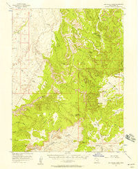
San Rafael Knob, Utah, USGS topographic map dated 1952.
Includes geographic coordinates (latitude and longitude). This topographic map is suitable for hiking, camping, and exploring, or framing it as a wall map.
Printed on-demand using high resolution imagery, on heavy weight and acid free paper, or alternatively on a variety of synthetic materials.
Topos available on paper, Waterproof, Poly, or Tyvek. Usually shipping rolled, unless combined with other folded maps in one order.
- Product Number: USGS-5462847
- Free digital map download (high-resolution, GeoPDF): San Rafael Knob, Utah (file size: 8 MB)
- Map Size: please refer to the dimensions of the GeoPDF map above
- Weight (paper map): ca. 55 grams
- Map Type: POD USGS Topographic Map
- Map Series: HTMC
- Map Verison: Historical
- Cell ID: 62091
- Scan ID: 251715
- Imprint Year: 1958
- Woodland Tint: Yes
- Aerial Photo Year: 1951
- Field Check Year: 1952
- Datum: NAD27
- Map Projection: Polyconic
- Map published by United States Geological Survey
- Map Language: English
- Scanner Resolution: 600 dpi
- Map Cell Name: San Rafael Knob
- Grid size: 15 X 15 Minute
- Date on map: 1952
- Map Scale: 1:62500
- Geographical region: Utah, United States
Neighboring Maps:
All neighboring USGS topo maps are available for sale online at a variety of scales.
Spatial coverage:
Topo map San Rafael Knob, Utah, covers the geographical area associated the following places:
- Obscure Arch - North Fork Coal Wash - Locomotive Point - Bullock Draw - Cow Canyon - Tan Seep - Forked Post Pond - Copper Globe - Cactus Flats - Joe and His Dog - Lucky Strike Mine - Eagle Canyon - Copper Golbe Mine - Eagle Canyon Arch - Square Top - Golden Gate - Reid Neilson Reservoir - Sagebrush Bench - Taylor Flat - South Fork Coal Wash - Link Flats - Swasey Cabin - Secret Mesa - Head of Sinbad - Sulphur Canyon - Rods Valley - Devils Monument - Chimney Rock - Sid and Charley - Swaseys Arch - The Blocks - Sinbad Valley - Cottonwood Spring - Ghost Rock - Link Flat Natural Area - Dutchman Arch - San Rafael Knob - Justensen Flats - Family Butte
- Map Area ID: AREA3938.75-111-110.75
- Northwest corner Lat/Long code: USGSNW39-111
- Northeast corner Lat/Long code: USGSNE39-110.75
- Southwest corner Lat/Long code: USGSSW38.75-111
- Southeast corner Lat/Long code: USGSSE38.75-110.75
- Northern map edge Latitude: 39
- Southern map edge Latitude: 38.75
- Western map edge Longitude: -111
- Eastern map edge Longitude: -110.75


