
~ Straight Canyon UT topo map, 1:24000 scale, 7.5 X 7.5 Minute, Historical, 1980, updated 1991
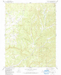
Straight Canyon, Utah, USGS topographic map dated 1980.
Includes geographic coordinates (latitude and longitude). This topographic map is suitable for hiking, camping, and exploring, or framing it as a wall map.
Printed on-demand using high resolution imagery, on heavy weight and acid free paper, or alternatively on a variety of synthetic materials.
Topos available on paper, Waterproof, Poly, or Tyvek. Usually shipping rolled, unless combined with other folded maps in one order.
- Product Number: USGS-5461127
- Free digital map download (high-resolution, GeoPDF): Straight Canyon, Utah (file size: 13 MB)
- Map Size: please refer to the dimensions of the GeoPDF map above
- Weight (paper map): ca. 55 grams
- Map Type: POD USGS Topographic Map
- Map Series: HTMC
- Map Verison: Historical
- Cell ID: 43403
- Scan ID: 252133
- Imprint Year: 1991
- Woodland Tint: Yes
- Aerial Photo Year: 1973
- Edit Year: 1980
- Field Check Year: 1974
- Datum: NAD27
- Map Projection: Polyconic
- Map published by United States Geological Survey
- Map Language: English
- Scanner Resolution: 600 dpi
- Map Cell Name: Straight Canyon
- Grid size: 7.5 X 7.5 Minute
- Date on map: 1980
- Map Scale: 1:24000
- Geographical region: Utah, United States
Neighboring Maps:
All neighboring USGS topo maps are available for sale online at a variety of scales.
Spatial coverage:
Topo map Straight Canyon, Utah, covers the geographical area associated the following places:
- Hopp Canyon - Horse Knoll - Hay Canyon - Ashdown Canyon - Big Springs - Rosy Canyon - Millet Point - Oak Canyon - Straight Canyon - Lower Bear Spring - Right Fork Orderville Gulch - Stevens Canyon - Bulloch Canyon - Right Hand Canyon - Bauer Canyon - Little Hopp Canyon - Bulloch Spring - Upper Bear Spring - Seth Canyon - Millet Canyon - Chamberlains Ranch - Willow Canyon - The Plains - Right Hand Canyon - Dry Canyon - Willow Canyon
- Map Area ID: AREA37.537.375-112.875-112.75
- Northwest corner Lat/Long code: USGSNW37.5-112.875
- Northeast corner Lat/Long code: USGSNE37.5-112.75
- Southwest corner Lat/Long code: USGSSW37.375-112.875
- Southeast corner Lat/Long code: USGSSE37.375-112.75
- Northern map edge Latitude: 37.5
- Southern map edge Latitude: 37.375
- Western map edge Longitude: -112.875
- Eastern map edge Longitude: -112.75


