
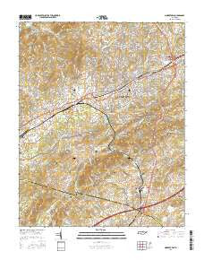
~ Morristown TN topo map, 1:24000 scale, 7.5 X 7.5 Minute, 2016
Morristown, Tennessee, USGS topographic map dated 2016.
Includes geographic coordinates (latitude and longitude). This topographic map is suitable for hiking, camping, and exploring, or framing it as a wall map.
Printed on-demand using high resolution imagery, on heavy weight and acid free paper, or alternatively on a variety of synthetic materials.
Topos available on paper, Waterproof, Poly, or Tyvek. Usually shipping rolled, unless combined with other folded maps in one order.
- Product Number: USGS-8016208
- Free digital map download (high-resolution, GeoPDF): Morristown, Tennessee (file size: 27 MB)
- Map Size: please refer to the dimensions of the GeoPDF map above
- Weight (paper map): ca. 55 grams
- Map Type: POD USGS Topographic Map
- Map Series: US Topo
- Map Verison: Current
- Cell ID: 30305
- Datum: North American Datum of 1983
- Map Projection: Transverse Mercator
- Map Cell Name: Morristown
- Grid size: 7.5 X 7.5 Minute
- Date on map: 2016
- Map Scale: 1:24000
- Geographical region: Tennessee, United States
Neighboring Maps:
All neighboring USGS topo maps are available for sale online at a variety of scales.
Spatial coverage:
Topo map Morristown, Tennessee, covers the geographical area associated the following places:
- West Hills - Witt Acres - Coulter - Beechnut Subdivision - Tigertown - Brentwood - Rolling Hills - Witt - Monte Vista Estates - Taylor Estates - Kilgore Subdivision - Dogwood Hills - Hillcrest - Havley Springs - Sequooyah Estates - Oakwood - Corpening HIlls - Campbell Acres - Mulberry Acres - Southern Heights - Crockett Ridge - Eureka Hills - Drinnon Heights - Emerald Acres - Lakeview - Hidden Acres - Vantage View - Westview - North Brook - Mapleview Acres - Holly Hills - Liberty Heights - Carter Acres - Hales Crossroads - Wildwood - Greenwood Acres - Casablanca - Echo Hills - Westivew Woods - Ridgeview - Hallmark Estates - Roe Junction - Landmark Estates - Edgewood - Sunset Hills - Roe - Morristown - Fernwood - Fernwood Heights - The Meadows - Lynndale - Dalton Heights - The Colonies - Sulphur Springs - Depew Addition
- Map Area ID: AREA36.2536.125-83.375-83.25
- Northwest corner Lat/Long code: USGSNW36.25-83.375
- Northeast corner Lat/Long code: USGSNE36.25-83.25
- Southwest corner Lat/Long code: USGSSW36.125-83.375
- Southeast corner Lat/Long code: USGSSE36.125-83.25
- Northern map edge Latitude: 36.25
- Southern map edge Latitude: 36.125
- Western map edge Longitude: -83.375
- Eastern map edge Longitude: -83.25


