
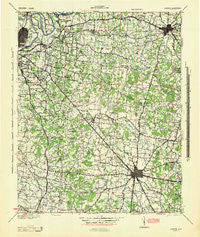
~ Lebanon TN topo map, 1:100000 scale, 30 X 30 Minute, Historical, 1942, updated 1944
Lebanon, Tennessee, USGS topographic map dated 1942.
Includes geographic coordinates (latitude and longitude). This topographic map is suitable for hiking, camping, and exploring, or framing it as a wall map.
Printed on-demand using high resolution imagery, on heavy weight and acid free paper, or alternatively on a variety of synthetic materials.
Topos available on paper, Waterproof, Poly, or Tyvek. Usually shipping rolled, unless combined with other folded maps in one order.
- Product Number: USGS-5689656
- Free digital map download (high-resolution, GeoPDF): Lebanon, Tennessee (file size: 12 MB)
- Map Size: please refer to the dimensions of the GeoPDF map above
- Weight (paper map): ca. 55 grams
- Map Type: POD USGS Topographic Map
- Map Series: HTMC
- Map Verison: Historical
- Cell ID: 396034
- Scan ID: 149953
- Imprint Year: 1944
- Woodland Tint: Yes
- Aerial Photo Year: 1938
- Edit Year: 1943
- Datum: NAD27
- Map Projection: Polyconic
- Map published by United States Army Corps of Engineers
- Map published by United States Department of War
- Map Language: English
- Scanner Resolution: 600 dpi
- Map Cell Name: Lebanon
- Grid size: 30 X 30 Minute
- Date on map: 1942
- Map Scale: 1:100000
- Geographical region: Tennessee, United States
Neighboring Maps:
All neighboring USGS topo maps are available for sale online at a variety of scales.
Spatial coverage:
Topo map Lebanon, Tennessee, covers the geographical area associated the following places:
- Pleasant Grove - Hopewell - Almaville - Denny Hills - Hickory Valley Estates - Timberlake - Emery Estates - Woodlake - Curry (historical) - Oakwood - Park Manor - Rockdale - Caravelle - Palmer Acres South - Hermitage Hills - Compton - Beasley Road - Yearwood Addition - Harbor View - Oak Hill - Parkwood Estates - Manson Manor - Riverview - Loafers Corner - Walter Hill Estates - Inglewood - Jackson Ridge - Wrencoe - Maple Hill - Lamb - Oakwood Terrace - Georgetown - Hilltop - Hunters Store - Georgemere - Lake Colonial Estates - Jackson Hollow - Compton Meadows - Franklin Road Estates - Providence - Riverwood - Vesta - In-A-Vale-Estates - Ravenwood - Glaze - Monte Carlo Estates - Aberdeen Park - Town Park Estates - Hite (historical) - Smyrna - Josephine (historical) - Dog Town (historical) - Browns Mill - Cooks Corner - Smith Springs - Brooklin - Rowland Estates - Cherry Hill Estates - Paschal Estates - Jimtown (historical) - Joyceland - Lampkin Bridge Estates - Watson - Belinda City - Bethel - Travis - Loveville (historical) - Neal Circle - Whispering Hills - Fieldcrest - Joywood - Egan - Blansett Meadows - Radnor - Mount Juliet - Nolensville - Southwood Estates - Oakwood - Kittrell Heights - Deerfield - Joneswood - Suggs Creek - Woodbine - Rosebank - Mount Carmel (historical) - Concord Forest - Bethel - Sunset Acres - Belle Mead - Emmitt Heights - Cloverhill - Lebanon - Kimbro - Fairfield Estates - Rocky Fork - Merry Oaks - Triune - Royal Court - Clearview - Southern Aire
- Map Area ID: AREA36.2535.75-86.75-86.25
- Northwest corner Lat/Long code: USGSNW36.25-86.75
- Northeast corner Lat/Long code: USGSNE36.25-86.25
- Southwest corner Lat/Long code: USGSSW35.75-86.75
- Southeast corner Lat/Long code: USGSSE35.75-86.25
- Northern map edge Latitude: 36.25
- Southern map edge Latitude: 35.75
- Western map edge Longitude: -86.75
- Eastern map edge Longitude: -86.25


