
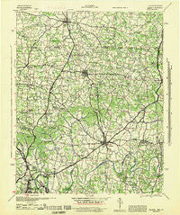
~ Gallatin TN topo map, 1:100000 scale, 30 X 30 Minute, Historical, 1942
Gallatin, Tennessee, USGS topographic map dated 1942.
Includes geographic coordinates (latitude and longitude). This topographic map is suitable for hiking, camping, and exploring, or framing it as a wall map.
Printed on-demand using high resolution imagery, on heavy weight and acid free paper, or alternatively on a variety of synthetic materials.
Topos available on paper, Waterproof, Poly, or Tyvek. Usually shipping rolled, unless combined with other folded maps in one order.
- Product Number: USGS-5689654
- Free digital map download (high-resolution, GeoPDF): Gallatin, Tennessee (file size: 12 MB)
- Map Size: please refer to the dimensions of the GeoPDF map above
- Weight (paper map): ca. 55 grams
- Map Type: POD USGS Topographic Map
- Map Series: HTMC
- Map Verison: Historical
- Cell ID: 396023
- Scan ID: 149884
- Woodland Tint: Yes
- Aerial Photo Year: 1938
- Datum: NAD27
- Map Projection: Polyconic
- Map published by United States Army Corps of Engineers
- Map published by United States Department of War
- Map Language: English
- Scanner Resolution: 600 dpi
- Map Cell Name: Gallatin
- Grid size: 30 X 30 Minute
- Date on map: 1942
- Map Scale: 1:100000
- Geographical region: Tennessee, United States
Neighboring Maps:
All neighboring USGS topo maps are available for sale online at a variety of scales.
Spatial coverage:
Topo map Gallatin, Tennessee, covers the geographical area associated the following places:
- Sulphura - Rocky Creek Subdivision - Panorama Harbor - Colonial Acres - Fairfield - Rolling Acres - Melrose (historical) - Scottish Highlands - Oakvale - Cherokee Woods - McElroy Ford - Bornes Ford - Cummings Crossroads - Pleasant Valley - Castalian Springs - Hickory Flat - Nonaville - Turners Station - Hillwood - Prices Mill - Sugar Grove - Providence - Highland Rim Terrace - Brackentown - Laguardo - Mount Vernon - Smyrna (historical) - Kansas - Neosheo - Curtiswood - Twin Valley - Owen Estates - Point O'View - Chestnut Hill - Eubanks Ford - Adolphus - Indian Forest - Old Hickory - Cross Plains - Geddes - Desha - Raintree Estates - Cottontown - Oak Grove (historical) - Reubensville - Lohman - White House - Antioch - Trousdale - Rayon City - Schweizer - Peytona - Driftwood Park - Round Pond (historical) - Orlinda - Mulloy - Rogana - Pondville - Clare - Corinth - Delray Park Estates - Millersville - Chestnut Grove - Rosewood - Hendersonville - Oakland - Rockland - Avondale - Odum (historical) - Mims (historical) - Bransford - Rock Bridge - Northcreek Commons - The Maples - Cedarbrook - Baggettsville - Hickory Grove - Pipers Chapel - Sarah Berry Annex - Meadowvale - Oakland - Lakeside Park - Black Jack Road (historical) - Handleyton - Mitchell - Red Hill - Bon Air - Peaceful Acres - Goodlettsville - Graball - High Chaparral - Madison - Cedar Grove - Rolling Acres - Hartsville Junction - Chapel Hill - Walton (historical) - New Deal - Highland Acres - Cedar Grove
- Map Area ID: AREA36.7536.25-86.75-86.25
- Northwest corner Lat/Long code: USGSNW36.75-86.75
- Northeast corner Lat/Long code: USGSNE36.75-86.25
- Southwest corner Lat/Long code: USGSSW36.25-86.75
- Southeast corner Lat/Long code: USGSSE36.25-86.25
- Northern map edge Latitude: 36.75
- Southern map edge Latitude: 36.25
- Western map edge Longitude: -86.75
- Eastern map edge Longitude: -86.25


