
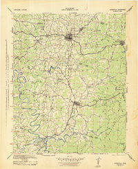
~ Cookeville TN topo map, 1:100000 scale, 30 X 30 Minute, Historical, 1943
Cookeville, Tennessee, USGS topographic map dated 1943.
Includes geographic coordinates (latitude and longitude). This topographic map is suitable for hiking, camping, and exploring, or framing it as a wall map.
Printed on-demand using high resolution imagery, on heavy weight and acid free paper, or alternatively on a variety of synthetic materials.
Topos available on paper, Waterproof, Poly, or Tyvek. Usually shipping rolled, unless combined with other folded maps in one order.
- Product Number: USGS-5689652
- Free digital map download (high-resolution, GeoPDF): Cookeville, Tennessee (file size: 10 MB)
- Map Size: please refer to the dimensions of the GeoPDF map above
- Weight (paper map): ca. 55 grams
- Map Type: POD USGS Topographic Map
- Map Series: HTMC
- Map Verison: Historical
- Cell ID: 396078
- Scan ID: 149610
- Woodland Tint: Yes
- Datum: NAD27
- Map Projection: Polyconic
- Map published by United States Army Corps of Engineers
- Map published by United States Department of War
- Map Language: English
- Scanner Resolution: 600 dpi
- Map Cell Name: Cookeville
- Grid size: 30 X 30 Minute
- Date on map: 1943
- Map Scale: 1:100000
- Geographical region: Tennessee, United States
Neighboring Maps:
All neighboring USGS topo maps are available for sale online at a variety of scales.
Spatial coverage:
Topo map Cookeville, Tennessee, covers the geographical area associated the following places:
- Dibrell - Sweetgum - Spring Hill - Pinhook - Gibson Subdivision - Twin Oak - Walnut Grove - Burton - Mount Vernon - Oakdale - Lafayette - Campbell - Speck Subdivision - College Heights - Woodland Estates - Heathwood - Sand Springs - Findlay - Buck Lake Estates - Midway - Colonial Forest - Huntland - Garmar Subdivision - Brotherton - Bilbrey Park - Maddux Farm - Melrose - Brandywine Estates - Bilbrey - Cherry Hill - Bussell - Cassville - Ensor - Oakdale - Mount Vernon Estates - Cookeville - Forest Hills - Grandview - Union Hill - Suntree Subdivision - Post Oak - Dixieland - Hillwood - Williams Crossroads - Lake Valley - Cedar Spring - Deberry Subdivision - Burgess - Yankeetown - Cedar Hill - Springdale - Pleasant View - Algood - Deberry Heights - Petite Subdivision - Ford Estates - Green Acres - Thomas - Rock Island - Pleasant Ridge - Terry Subdivision - Lonewood - Mill Creek - Samaria - Walling - Baxter - Johnsons Chapel - Ridgewood Estates - Village Green - Rolling Acres - Quebeck - The Lowlands - Sparta Hills - Wildwood - Capshaw Woods - Post Oak Estates - Dry Valley - Hickory Hills - Indian Hills - Long Meadows - Sun Valley - Pinhook (historical) - O'Conner - Pine Hills - Cambridge - Keltonburg - Hillsdale - Jessie - Elijah (historical) - Southtown Village - Boiling Springs - Peeled Chestnut - Roberts - Perilla (historical) - Dodson - Double Springs - Country Club Estates - Mobra - River Hill - Yateston
- Map Area ID: AREA36.2535.75-85.75-85.25
- Northwest corner Lat/Long code: USGSNW36.25-85.75
- Northeast corner Lat/Long code: USGSNE36.25-85.25
- Southwest corner Lat/Long code: USGSSW35.75-85.75
- Southeast corner Lat/Long code: USGSSE35.75-85.25
- Northern map edge Latitude: 36.25
- Southern map edge Latitude: 35.75
- Western map edge Longitude: -85.75
- Eastern map edge Longitude: -85.25


