
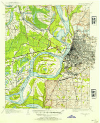
~ Memphis TN topo map, 1:62500 scale, 15 X 15 Minute, Historical, 1916, updated 1954
Memphis, Tennessee, USGS topographic map dated 1916.
Includes geographic coordinates (latitude and longitude). This topographic map is suitable for hiking, camping, and exploring, or framing it as a wall map.
Printed on-demand using high resolution imagery, on heavy weight and acid free paper, or alternatively on a variety of synthetic materials.
Topos available on paper, Waterproof, Poly, or Tyvek. Usually shipping rolled, unless combined with other folded maps in one order.
- Product Number: USGS-5679943
- Free digital map download (high-resolution, GeoPDF): Memphis, Tennessee (file size: 10 MB)
- Map Size: please refer to the dimensions of the GeoPDF map above
- Weight (paper map): ca. 55 grams
- Map Type: POD USGS Topographic Map
- Map Series: HTMC
- Map Verison: Historical
- Cell ID: 57512
- Scan ID: 150224
- Imprint Year: 1954
- Woodland Tint: Yes
- Survey Year: 1916
- Datum: Unstated
- Map Projection: Polyconic
- Map published by United States Geological Survey
- Keywords: Overedge
- Map Language: English
- Scanner Resolution: 600 dpi
- Map Cell Name: Memphis
- Grid size: 15 X 15 Minute
- Date on map: 1916
- Map Scale: 1:62500
- Geographical region: Tennessee, United States
Neighboring Maps:
All neighboring USGS topo maps are available for sale online at a variety of scales.
Spatial coverage:
Topo map Memphis, Tennessee, covers the geographical area associated the following places:
- Gavin - Stonewall Place - Bauxippi (historical) - Sunset - Persey - Raines - Hunt Village - Amanca - Quarles - Galet - Presley Junction - West Junction - Wyanoke - Briark - Annesdale-Snowden - Darwin - Millers - Harvard - Pisgah Heights - Greenlaw - Riceville - Sylvan Heights - White Chapel - Acklena - Rosemary Lane - Almont (historical) - New Chelsea - Wylie Spur - Frayser - Bunker Hill - Lauderdale Courts - West Memphis - Waverly - Redman Point - Nonconnah - Rugby - Blanton - Dixie Homes - Goodman - Hopefield (historical) - Hulbert - Memphis - Mound City - New South Memphis - East Junction - Shadowlawn - Foote Homes - Whitehaven - Annesdale Park - Gammon - Felts - Saint Claire - Mallory - Marion
- Map Area ID: AREA35.2535-90.25-90
- Northwest corner Lat/Long code: USGSNW35.25-90.25
- Northeast corner Lat/Long code: USGSNE35.25-90
- Southwest corner Lat/Long code: USGSSW35-90.25
- Southeast corner Lat/Long code: USGSSE35-90
- Northern map edge Latitude: 35.25
- Southern map edge Latitude: 35
- Western map edge Longitude: -90.25
- Eastern map edge Longitude: -90


