
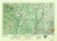
~ Memphis TN topo map, 1:250000 scale, 1 X 2 Degree, Historical, 1956
Memphis, Tennessee, USGS topographic map dated 1956.
Includes geographic coordinates (latitude and longitude). This topographic map is suitable for hiking, camping, and exploring, or framing it as a wall map.
Printed on-demand using high resolution imagery, on heavy weight and acid free paper, or alternatively on a variety of synthetic materials.
Topos available on paper, Waterproof, Poly, or Tyvek. Usually shipping rolled, unless combined with other folded maps in one order.
- Product Number: USGS-5339246
- Free digital map download (high-resolution, GeoPDF): Memphis, Tennessee (file size: 21 MB)
- Map Size: please refer to the dimensions of the GeoPDF map above
- Weight (paper map): ca. 55 grams
- Map Type: POD USGS Topographic Map
- Map Series: HTMC
- Map Verison: Historical
- Cell ID: 68906
- Scan ID: 150227
- Woodland Tint: Yes
- Field Check Year: 1953
- Datum: Unstated
- Map Projection: Transverse Mercator
- Map published by United States Army Corps of Engineers
- Map published by United States Army
- Map Language: English
- Scanner Resolution: 600 dpi
- Map Cell Name: Memphis
- Grid size: 1 X 2 Degree
- Date on map: 1956
- Map Scale: 1:250000
- Geographical region: Tennessee, United States
Neighboring Maps:
All neighboring USGS topo maps are available for sale online at a variety of scales.
Spatial coverage:
Topo map Memphis, Tennessee, covers the geographical area associated the following places:
- Wick Mill - Davenport (historical) - Wrape (historical) - Red Line - Madison - Merck (historical) - Aberdeen (historical) - Three Forks - McDonald - Cotton Plant - Greenfield - Engledale (historical) - Pleasant Plains - Cottonwood Corner - Sterling Springs - Lafferty - Cash - Poplar Corner - Tyronza - Nemo - Harris - Pleasant Grove - Southside - Ebony - Upper Poplar Ridge - Blanton - Darwin - Pfeiffer - Magness - Diaz - Cow Lake (historical) - Shaw (historical) - Jamestown - Pleasant Hill - Cherry Valley - Shoffner - Tyronza Junction - Amanca - Fitzgerald - Carmi - Underwood (historical) - Deans Island - Heafer - Brown (historical) - Olyphant - Buckeye - Sturdevant (historical) - River Front - Antioch - Dewey - Newark - Whisp - Arthur (historical) - Pickens - Tumbling Shoals - Meadow Heights - Presley Junction - Stacy - Paroquet - Gibson - Clay - Scarb (historical) - Gid - Oil Trough - Clear Water (historical) - Saint James - Kahoka (historical) - Sulphur Rock - Bengel - Daggett - Pleasant Grove - Gladden - Airport Village - Algoa - Gainsboro - Crow Creek - Crosby - Wildwood - Blackville - Bare Stone - Stegall - Estico - Shonyo (historical) - Wilburn - Doss (historical) - Lost Cane - Ellen (historical) - New Home - Rugby - Pleasant Hill - Bryant Woodland Heights - Annesdale-Snowden - Saint Claire - Three Way - Weona - Earnheart - Riverview - Macks - Aetna - Nasco
- Map Area ID: AREA3635-92-90
- Northwest corner Lat/Long code: USGSNW36-92
- Northeast corner Lat/Long code: USGSNE36-90
- Southwest corner Lat/Long code: USGSSW35-92
- Southeast corner Lat/Long code: USGSSE35-90
- Northern map edge Latitude: 36
- Southern map edge Latitude: 35
- Western map edge Longitude: -92
- Eastern map edge Longitude: -90


