
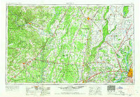
~ Memphis TN topo map, 1:250000 scale, 1 X 2 Degree, Historical, 1953, updated 1966
Memphis, Tennessee, USGS topographic map dated 1953.
Includes geographic coordinates (latitude and longitude). This topographic map is suitable for hiking, camping, and exploring, or framing it as a wall map.
Printed on-demand using high resolution imagery, on heavy weight and acid free paper, or alternatively on a variety of synthetic materials.
Topos available on paper, Waterproof, Poly, or Tyvek. Usually shipping rolled, unless combined with other folded maps in one order.
- Product Number: USGS-5339244
- Free digital map download (high-resolution, GeoPDF): Memphis, Tennessee (file size: 15 MB)
- Map Size: please refer to the dimensions of the GeoPDF map above
- Weight (paper map): ca. 55 grams
- Map Type: POD USGS Topographic Map
- Map Series: HTMC
- Map Verison: Historical
- Cell ID: 68906
- Scan ID: 150226
- Imprint Year: 1966
- Woodland Tint: Yes
- Edit Year: 1965
- Field Check Year: 1953
- Datum: Unstated
- Map Projection: Transverse Mercator
- Map published by United States Geological Survey
- Map published by United States Army Corps of Engineers
- Map published by United States Army
- Map Language: English
- Scanner Resolution: 600 dpi
- Map Cell Name: Memphis
- Grid size: 1 X 2 Degree
- Date on map: 1953
- Map Scale: 1:250000
- Geographical region: Tennessee, United States
Neighboring Maps:
All neighboring USGS topo maps are available for sale online at a variety of scales.
Spatial coverage:
Topo map Memphis, Tennessee, covers the geographical area associated the following places:
- Proctor - Big Spring Mill - Floodway - Bare Stone - March (historical) - Concord - Parkin - Fair Field - Hancock Junction - Old Weona - Ramsey - Deep Landing - Pecan Point - Sunrise (historical) - Jester (historical) - Burnt Cane - Wrape (historical) - Tuscany (historical) - Willard (historical) - Rugby - Cedar Grove - Simsboro - McElroy - Dryden - Maple Grove - Nemo - Grays - Hamlin - McDonald - Davis Spur - Winesburg - Hunter - Leachville - Boat Run - Hutchinson - Buck Snort - Brice - Donnick - Cary - Waverly - Arthur (historical) - Obear (historical) - Hillemann - Felco - McHue - McCrory - Round Pond - Airport Village - Bethesda - Shady Grove - Shannonville - Vinity Corner - Stineville (historical) - Woodland Corner - Collietown - Cottonwood Corner - Flynn (historical) - Maysville (historical) - Shadowlawn - Goodman - Raines - Morton - Credit (historical) - Aberdeen (historical) - Dixie - McCormick - Daggett - Wylie Spur - Sharp - Gid - Strangers Home - Wardell - Persey - Belknap (historical) - Springfield (historical) - Enright - Risher - Merced (historical) - New South Memphis - Gourd Neck - Kensett - Saint Claire - Whistleville - Brown (historical) - Norden - Ellen (historical) - L'Anguille - Trumann - Little Red - Colton Crossing - Hunterton (historical) - Dennison Heights - Clearwater - Big Lake - Denton Island - Upper Poplar Ridge - Rokey - Spriggs Mill - Heafer - Greenfield
- Map Area ID: AREA3635-92-90
- Northwest corner Lat/Long code: USGSNW36-92
- Northeast corner Lat/Long code: USGSNE36-90
- Southwest corner Lat/Long code: USGSSW35-92
- Southeast corner Lat/Long code: USGSSE35-90
- Northern map edge Latitude: 36
- Southern map edge Latitude: 35
- Western map edge Longitude: -92
- Eastern map edge Longitude: -90


