
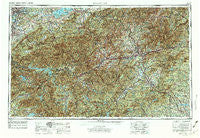
~ Knoxville TN topo map, 1:250000 scale, 1 X 2 Degree, Historical, 1957, updated 1974
Knoxville, Tennessee, USGS topographic map dated 1957.
Includes geographic coordinates (latitude and longitude). This topographic map is suitable for hiking, camping, and exploring, or framing it as a wall map.
Printed on-demand using high resolution imagery, on heavy weight and acid free paper, or alternatively on a variety of synthetic materials.
Topos available on paper, Waterproof, Poly, or Tyvek. Usually shipping rolled, unless combined with other folded maps in one order.
- Product Number: USGS-5339240
- Free digital map download (high-resolution, GeoPDF): Knoxville, Tennessee (file size: 25 MB)
- Map Size: please refer to the dimensions of the GeoPDF map above
- Weight (paper map): ca. 55 grams
- Map Type: POD USGS Topographic Map
- Map Series: HTMC
- Map Verison: Historical
- Cell ID: 68859
- Scan ID: 148019
- Imprint Year: 1974
- Woodland Tint: Yes
- Visual Version Number: 2
- Photo Revision Year: 1972
- Aerial Photo Year: 1971
- Edit Year: 1972
- Field Check Year: 1957
- Datum: Unstated
- Map Projection: Transverse Mercator
- Map published by United States Army Corps of Engineers
- Map published by United States Army
- Map Language: English
- Scanner Resolution: 600 dpi
- Map Cell Name: Knoxville
- Grid size: 1 X 2 Degree
- Date on map: 1957
- Map Scale: 1:250000
- Geographical region: Tennessee, United States
Neighboring Maps:
All neighboring USGS topo maps are available for sale online at a variety of scales.
Spatial coverage:
Topo map Knoxville, Tennessee, covers the geographical area associated the following places:
- Leatherman - Fisher Creek - Woodland Trace - Mount Olive - Littlebrook - Carolina Mountains - Lendaw - De Hart Mill - Crabtree - Rosebank Park - Camelot - Quail Ridge - Eaglenest (historical) - Ivy Ridge - Beverly Hills - Stony Point - Brevard - Big Laurel - Ridge Haven - Highland Acres - Milltown - Cross William MHP - Mills River - Foster - Minpro - Tara Estates - Lake Forest - Copper Ford - Scaly Mountain - Highland Park - Ivy - Edneyville - Cheoah - Pisgah Forest - Lake Junaluska - Mill Spring - Unahala - Walland - Tulula - Oldham - Beta - Dupont - Grace - Bethel - Pole Creek - West Springbrook - Almond - Newell Station - Sherwood Terrace - East Fork - Rocky Grove - Northport - Foster Creek - Inman Mills - Bryson City - Runion - Dumplin Mill - Redwood Village - Shooting Creek - Beulah - East Fork - Lonsdale - Texas Settlement (historical) - Shaleville - Oakley - Rocky Hill - Lakemont - Boyds Creek - McGinnis Crossroads - Mountain Lake Camp - Forest Hills - Twin Brooks - Moffitt Hill - Turnpike - Flat Top - Riverview - Naillon (historical) - Wesser - Pisgah View - Maple Springs - West Haven - Willard Addition - Henry Crossroads - Forest Hill - Wildwood - Valley View Vistas - Indian Hills - Green Acres - Worley - Spur Trailer Park - Five Oaks - Wimbledon - West Knoxville - Deep Springs - Mountain View Addition - Dula Springs - Deep Creek - Stock Creek - Wilton Springs - Oak City
- Map Area ID: AREA3635-84-82
- Northwest corner Lat/Long code: USGSNW36-84
- Northeast corner Lat/Long code: USGSNE36-82
- Southwest corner Lat/Long code: USGSSW35-84
- Southeast corner Lat/Long code: USGSSE35-82
- Northern map edge Latitude: 36
- Southern map edge Latitude: 35
- Western map edge Longitude: -84
- Eastern map edge Longitude: -82


