
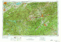
~ Knoxville TN topo map, 1:250000 scale, 1 X 2 Degree, Historical, 1957, updated 1973
Knoxville, Tennessee, USGS topographic map dated 1957.
Includes geographic coordinates (latitude and longitude). This topographic map is suitable for hiking, camping, and exploring, or framing it as a wall map.
Printed on-demand using high resolution imagery, on heavy weight and acid free paper, or alternatively on a variety of synthetic materials.
Topos available on paper, Waterproof, Poly, or Tyvek. Usually shipping rolled, unless combined with other folded maps in one order.
- Product Number: USGS-5339236
- Free digital map download (high-resolution, GeoPDF): Knoxville, Tennessee (file size: 22 MB)
- Map Size: please refer to the dimensions of the GeoPDF map above
- Weight (paper map): ca. 55 grams
- Map Type: POD USGS Topographic Map
- Map Series: HTMC
- Map Verison: Historical
- Cell ID: 68859
- Scan ID: 148017
- Imprint Year: 1973
- Woodland Tint: Yes
- Edit Year: 1966
- Field Check Year: 1957
- Datum: Unstated
- Map Projection: Transverse Mercator
- Map published by United States Army Corps of Engineers
- Map published by United States Army
- Map Language: English
- Scanner Resolution: 600 dpi
- Map Cell Name: Knoxville
- Grid size: 1 X 2 Degree
- Date on map: 1957
- Map Scale: 1:250000
- Geographical region: Tennessee, United States
Neighboring Maps:
All neighboring USGS topo maps are available for sale online at a variety of scales.
Spatial coverage:
Topo map Knoxville, Tennessee, covers the geographical area associated the following places:
- Rymers Ferry - Indian Hills - Country Club Estates - Tryon - Belmont Addition - Hartford - Bethel - Sevierville - Foster Creek - Cox Store - Barker Heights - Chanteloupe Country Estates - Wildacres - Millbrook Estates - Thomas Woods - Oak City - Youngs Mountain - Country Ridge - Mission - Fox (historical) - Union Grove - Topton - Fleetwood Estates - Azalea - Brasstown - Luck - Black Mountain - Fontana Village - Highlands - Highland - Westminister Ridge - Melrose - Naples - Richardson Cove - Rockgardens - English - Walnut - Patton Mountain Estates - Enka - Benford Heights Addition - Kanuga Ridge - Tuscola Park - Maggie Valley - Rosebud - Leicester - Lackey Hill - Stoney Mountain Estate - Tom Town - Wolf Ford - Gashes Creek - Valley Grove - The Pines - Plainfield - Crossfield - Riverdale - Tumblerville - Bird Crossroad - McGuires - Finlay Brook - Mountain Home - Belva - Gatlinburg - White Rock - Wear Valley - Spring Hill - Crooked Creek - Hillandale - Mills River - Willow Wew - Cane Brake - Birdtown - Cross Plains - Lakemont - Sylva - Paint Fork - Shookville - Wildwood Park (historical) - Hendersonville - Trust - Reid - South View Estates - Powelltown - Sky Village - Altapass - Acton - Mars Hill - Emerald Hills Estates - Padgett Mill - Naillontown (historical) - Cook Mill - Hewitt - Fingerville - Crenshaw - Click Mill - Beech Glen - Pigeon Forge - Butt Mountain - Hickory Hill - Lendaw - Blue Ridge
- Map Area ID: AREA3635-84-82
- Northwest corner Lat/Long code: USGSNW36-84
- Northeast corner Lat/Long code: USGSNE36-82
- Southwest corner Lat/Long code: USGSSW35-84
- Southeast corner Lat/Long code: USGSSE35-82
- Northern map edge Latitude: 36
- Southern map edge Latitude: 35
- Western map edge Longitude: -84
- Eastern map edge Longitude: -82


