
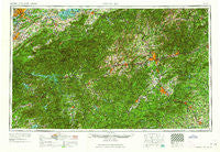
~ Knoxville TN topo map, 1:250000 scale, 1 X 2 Degree, Historical, 1964
Knoxville, Tennessee, USGS topographic map dated 1964.
Includes geographic coordinates (latitude and longitude). This topographic map is suitable for hiking, camping, and exploring, or framing it as a wall map.
Printed on-demand using high resolution imagery, on heavy weight and acid free paper, or alternatively on a variety of synthetic materials.
Topos available on paper, Waterproof, Poly, or Tyvek. Usually shipping rolled, unless combined with other folded maps in one order.
- Product Number: USGS-5339232
- Free digital map download (high-resolution, GeoPDF): Knoxville, Tennessee (file size: 21 MB)
- Map Size: please refer to the dimensions of the GeoPDF map above
- Weight (paper map): ca. 55 grams
- Map Type: POD USGS Topographic Map
- Map Series: HTMC
- Map Verison: Historical
- Cell ID: 68859
- Scan ID: 148015
- Woodland Tint: Yes
- Field Check Year: 1957
- Datum: Unstated
- Map Projection: Transverse Mercator
- Map published by United States Army Corps of Engineers
- Map published by United States Army
- Map Language: English
- Scanner Resolution: 600 dpi
- Map Cell Name: Knoxville
- Grid size: 1 X 2 Degree
- Date on map: 1964
- Map Scale: 1:250000
- Geographical region: Tennessee, United States
Neighboring Maps:
All neighboring USGS topo maps are available for sale online at a variety of scales.
Spatial coverage:
Topo map Knoxville, Tennessee, covers the geographical area associated the following places:
- Westminister Ridge - Iris Acres - Ruby City - Williamsburg - Whites Village - Lawson Crossroad - Mountainbrook - Twin Oak Estates - Balsam - Pinehurst - Mountain Trace - Pleasant Gardens - Berry Mill - North Cove Crossing - Birdtown - Conner Heights - Shooks Gap - Sunny View - Allensville (historical) - East Fork - Rivertrace - West View - Piney Woods - McCookville - Lavinia (historical) - Mills River - Peniel - Lakewood - Bluff - Glady - Wesser - Echo Lakes - Bayview - Dendron - Little Cove - Boylston Creek - Shiloh - Edgewood Acres - Knob Creek - River Oak Ranchettes - Slickrock Ford - Fox Hills - Sales Ford - Graphite - Poplar Grove - Seaton Spring - Buena Vista - Bird Crossroad - Mountain Valley - Malvern Hills - Seymour Heights - Gerton - Burningtown - Five Points - Franklin - Druid Hills - Clevenger - Spring Creek - Flat Top - Twin Brooks - Tuscola Park - Leatherman - Davistown - Rice Mill - Rugby - Quail Ridge - Acton - Melrose - Brooklawn Park - Caton - Sunset View - Sycamore - East Flat Rock - Peachtree - Beechertown - Hidden Valley - Campton - Suttontown - Murphy Junction - Knoxville - Meadowbrook - Golf Estates - Seven Springs - Marshall - West Marion - Indian Cove - Middle Creek - Oak Forest - Deerwoods Estates - Panther Creek - River Forest - New Candler - Scenic Terrace - Lake Lanier - Terry Creek - Redwood Village - Chandler - Slick Rock - Bryson City - Kalmia
- Map Area ID: AREA3635-84-82
- Northwest corner Lat/Long code: USGSNW36-84
- Northeast corner Lat/Long code: USGSNE36-82
- Southwest corner Lat/Long code: USGSSW35-84
- Southeast corner Lat/Long code: USGSSE35-82
- Northern map edge Latitude: 36
- Southern map edge Latitude: 35
- Western map edge Longitude: -84
- Eastern map edge Longitude: -82


