
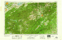
~ Knoxville TN topo map, 1:250000 scale, 1 X 2 Degree, Historical, 1960
Knoxville, Tennessee, USGS topographic map dated 1960.
Includes geographic coordinates (latitude and longitude). This topographic map is suitable for hiking, camping, and exploring, or framing it as a wall map.
Printed on-demand using high resolution imagery, on heavy weight and acid free paper, or alternatively on a variety of synthetic materials.
Topos available on paper, Waterproof, Poly, or Tyvek. Usually shipping rolled, unless combined with other folded maps in one order.
- Product Number: USGS-5339230
- Free digital map download (high-resolution, GeoPDF): Knoxville, Tennessee (file size: 23 MB)
- Map Size: please refer to the dimensions of the GeoPDF map above
- Weight (paper map): ca. 55 grams
- Map Type: POD USGS Topographic Map
- Map Series: HTMC
- Map Verison: Historical
- Cell ID: 68859
- Scan ID: 148014
- Woodland Tint: Yes
- Visual Version Number: 2
- Aerial Photo Year: 1951
- Datum: Unstated
- Map Projection: Transverse Mercator
- Map published by United States Army Corps of Engineers
- Map published by United States Army
- Map Language: English
- Scanner Resolution: 600 dpi
- Map Cell Name: Knoxville
- Grid size: 1 X 2 Degree
- Date on map: 1960
- Map Scale: 1:250000
- Geographical region: Tennessee, United States
Neighboring Maps:
All neighboring USGS topo maps are available for sale online at a variety of scales.
Spatial coverage:
Topo map Knoxville, Tennessee, covers the geographical area associated the following places:
- Crestwood - Hominy - Walnut Creek - Cross Plains - Knob Hill - Bear Creek - Shady Grove - McGuires - Ingalls - Catons Grove - Chestnut Hill - Stockwood - Belle Meade - Glade - Holly Springs - Hensley (historical) - Coster Yards - Wilshire Park - Mimosa Estates - Laurel Park - Mascot - Campobello - Elajay (historical) - Tigerville - Thomas Forest - Nanney (historical) - Midway - Singleton - Ottanola - Stock Creek - Big Pine - Essex - Oak View - Boomer - Toxaway Falls - Beech - Bandana - Windom - Camelot - Beulah - Pine Shore Lakes - Emerald Hills Estates - Wildwood Park (historical) - Creekwood - Lakemoor Hills - English Hills - Bowlens Creek - Rymers Ferry - Fairfield - Jackson Line - Highland Hills - Middle Creek - Retreat - Long Ridge - East Biltmore - Glenlaurel - Hankins - McDonald Mill - Willard Addition - Mountain Grove - Maltby - Cross William MHP - Strawberry Ridge - Gay - Lakeview Estates - Cheoah - Ellejoy - Fort Harry - Ridgecrest - Mitchell (historical) - Pleasant Gardens - Knob (historical) - Druid Hills - Tuckasegee - Hayesville - Beechwood - Finlay Brook - Grassy Creek - Montford Hills - Tuxedo - Sunset View - Saconon - Allegheny - Union Grove - Flat Rock - Spring Creek - Oteen - Little River - Lake Forest - Kenwood Knolls - Sandy Plains - Indian Cave Park - Cherokee Park - Bald Creek - Sevier Heights - Mountain Lake Camp - Blackberry Inn - Cecil (historical) - Broadview Estates - Gage (historical)
- Map Area ID: AREA3635-84-82
- Northwest corner Lat/Long code: USGSNW36-84
- Northeast corner Lat/Long code: USGSNE36-82
- Southwest corner Lat/Long code: USGSSW35-84
- Southeast corner Lat/Long code: USGSSE35-82
- Northern map edge Latitude: 36
- Southern map edge Latitude: 35
- Western map edge Longitude: -84
- Eastern map edge Longitude: -82


