
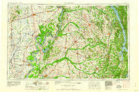
~ Dyersburg TN topo map, 1:250000 scale, 1 X 2 Degree, Historical, 1956, updated 1960
Dyersburg, Tennessee, USGS topographic map dated 1956.
Includes geographic coordinates (latitude and longitude). This topographic map is suitable for hiking, camping, and exploring, or framing it as a wall map.
Printed on-demand using high resolution imagery, on heavy weight and acid free paper, or alternatively on a variety of synthetic materials.
Topos available on paper, Waterproof, Poly, or Tyvek. Usually shipping rolled, unless combined with other folded maps in one order.
- Product Number: USGS-5339210
- Free digital map download (high-resolution, GeoPDF): Dyersburg, Tennessee (file size: 17 MB)
- Map Size: please refer to the dimensions of the GeoPDF map above
- Weight (paper map): ca. 55 grams
- Map Type: POD USGS Topographic Map
- Map Series: HTMC
- Map Verison: Historical
- Cell ID: 68760
- Scan ID: 148004
- Imprint Year: 1960
- Woodland Tint: Yes
- Field Check Year: 1956
- Datum: Unstated
- Map Projection: Transverse Mercator
- Map published by United States Army Corps of Engineers
- Map published by United States Army
- Map Language: English
- Scanner Resolution: 600 dpi
- Map Cell Name: Dyersburg
- Grid size: 1 X 2 Degree
- Date on map: 1956
- Map Scale: 1:250000
- Geographical region: Tennessee, United States
Neighboring Maps:
All neighboring USGS topo maps are available for sale online at a variety of scales.
Spatial coverage:
Topo map Dyersburg, Tennessee, covers the geographical area associated the following places:
- Coulter - Indian Mound - Kirksey - Catalpa - Tylersville - Kewanee - Guam - Sawyers Mill - Puryear - Cottage Grove - Commerce Landing - Red Hill - Sandy Bridge (historical) - Juanita (historical) - Idlewild - Moss (historical) - Braggadocio - Sedalia - Protemus - Clarkton - India - Pleasant Hill - Four Points - Pine Point Subdivision - Carnsville (historical) - Tennemo - Fancy - Ridgely - McCutchen Heights - Glass - Scott - Springville - Beech Grove (historical) - North Wardell - Blooming Grove - Marlow - Hailwell - Liberty - Midway - Riverside (historical) - Sidonia - Hooten (historical) - Wrightsville - Folsomdale - Prospect - Ayers - Kaler - Shiloh - Cat Corner - Mill Creek - Benton - Beech Grove (historical) - Bryans Ford - Grayridge - Jenkinsville - Blandville - Band Mill - Milburn - Viar - Benton Cut - Salcedo - Whiting - Yopp - Freemont - Bakers Crossroads - Samburg - Westbrook (historical) - Stone (historical) - Yama - Tanner - Hico - Troy - Elva - Baderville - Glendale - Lake Drive - Hamlet (historical) - Christian Chapel - Tyler - Broadmoor - Walnut Log - Owl City - Woodland Acres - Tinkerville - Monkey Den (historical) - Enon - Osage - Arlington - Harris Grove - Moscow - Mount Vista (historical) - Boothspoint - Ledford - Otis - Temple Hill (historical) - Stringtown - Mount Herman - Manleyville - Almo Heights - Briensburg
- Map Area ID: AREA3736-90-88
- Northwest corner Lat/Long code: USGSNW37-90
- Northeast corner Lat/Long code: USGSNE37-88
- Southwest corner Lat/Long code: USGSSW36-90
- Southeast corner Lat/Long code: USGSSE36-88
- Northern map edge Latitude: 37
- Southern map edge Latitude: 36
- Western map edge Longitude: -90
- Eastern map edge Longitude: -88


