
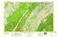
~ Chattanooga TN topo map, 1:250000 scale, 1 X 2 Degree, Historical, 1960
Chattanooga, Tennessee, USGS topographic map dated 1960.
Includes geographic coordinates (latitude and longitude). This topographic map is suitable for hiking, camping, and exploring, or framing it as a wall map.
Printed on-demand using high resolution imagery, on heavy weight and acid free paper, or alternatively on a variety of synthetic materials.
Topos available on paper, Waterproof, Poly, or Tyvek. Usually shipping rolled, unless combined with other folded maps in one order.
- Product Number: USGS-5339192
- Free digital map download (high-resolution, GeoPDF): Chattanooga, Tennessee (file size: 21 MB)
- Map Size: please refer to the dimensions of the GeoPDF map above
- Weight (paper map): ca. 55 grams
- Map Type: POD USGS Topographic Map
- Map Series: HTMC
- Map Verison: Historical
- Cell ID: 72221
- Scan ID: 148898
- Woodland Tint: Yes
- Aerial Photo Year: 1944
- Datum: NAD27
- Map Projection: Transverse Mercator
- Map published by United States Geological Survey
- Map Language: English
- Scanner Resolution: 600 dpi
- Map Cell Name: Chattanooga
- Grid size: 1 X 2 Degree
- Date on map: 1960
- Map Scale: 1:250000
- Geographical region: Tennessee, United States
Neighboring Maps:
All neighboring USGS topo maps are available for sale online at a variety of scales.
Spatial coverage:
Topo map Chattanooga, Tennessee, covers the geographical area associated the following places:
- Pine Grove - Pine Grove Estates - Hamburg - Rainbow Hills - Peeled Chestnut - Fox Fire - Whispering Hills - Ryall Springs - Luttrell - Harbor Hills - Paint Rock Farm Lake Estates - Philadelphia - Smyrna - Valley Home - Ridge Bay - Timberwick - Rogers Creek - Rymers (historical) - Browntown - Bryant - Storie - Craigmar (historical) - Lake-A-Wana - Tasso - Nantahala Estates - Andrea Heights - Bella Mara Estates - Campaign - Dogwood Heights - Roark Cove - Chestnut Hills - East Cleveland - Holly Heights - Coleman Subdivision - Hidden Hollow Estates - Mount Harmony - Windwood - Golden Oaks Estates - Tiptop - Fountain Village - Gold Point Estates - Harriman Junction - Mount Zion - Lanier - Mountain (historical) - Farner - Edgewater Estates - Sugarlimb - Hubbards Cove - Paint Rock - Archville - Greenback - Sherril Heights - Baker Crossroads - Auburn Hills - Union - Sink (historical) - Windsor Bluff - Pond Grove - Sentinel Heights - Eagles Landing Mobile Home Park - New Bethel - Waucheesi - Morrisgap (historical) - Green Cove - The Meadows - White Oak Forest - East View - Clearwater - Echo Glen - Rockville - Indian Hills - Collins - Fields of the Wood - Binfield - Lorraine - Forestdale - Washington Hills - Hambright - Golden Meadows - Apollo Shores - Harrison Trailer Park - Woodlawn - Eagle Furnace - Wolf Creek - Middle Brook Place - Pumpkin Center - Decatur - Sale Creek - Jewett - Brakebill (historical) - Adolphus - Pomona - Camp Ocoee - Bartlebaugh - Vests - Hickory Woods - Castaway Cove - Winton Town - Belltown
- Map Area ID: AREA3635-86-84
- Northwest corner Lat/Long code: USGSNW36-86
- Northeast corner Lat/Long code: USGSNE36-84
- Southwest corner Lat/Long code: USGSSW35-86
- Southeast corner Lat/Long code: USGSSE35-84
- Northern map edge Latitude: 36
- Southern map edge Latitude: 35
- Western map edge Longitude: -86
- Eastern map edge Longitude: -84


