
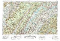
~ Chattanooga TN topo map, 1:250000 scale, 1 X 2 Degree, Historical, 1957, updated 1979
Chattanooga, Tennessee, USGS topographic map dated 1957.
Includes geographic coordinates (latitude and longitude). This topographic map is suitable for hiking, camping, and exploring, or framing it as a wall map.
Printed on-demand using high resolution imagery, on heavy weight and acid free paper, or alternatively on a variety of synthetic materials.
Topos available on paper, Waterproof, Poly, or Tyvek. Usually shipping rolled, unless combined with other folded maps in one order.
- Product Number: USGS-5339184
- Free digital map download (high-resolution, GeoPDF): Chattanooga, Tennessee (file size: 23 MB)
- Map Size: please refer to the dimensions of the GeoPDF map above
- Weight (paper map): ca. 55 grams
- Map Type: POD USGS Topographic Map
- Map Series: HTMC
- Map Verison: Historical
- Cell ID: 72221
- Scan ID: 148894
- Imprint Year: 1979
- Woodland Tint: Yes
- Photo Revision Year: 1972
- Aerial Photo Year: 1972
- Edit Year: 1972
- Field Check Year: 1957
- Datum: NAD27
- Map Projection: Transverse Mercator
- Map published by United States Geological Survey
- Map Language: English
- Scanner Resolution: 600 dpi
- Map Cell Name: Chattanooga
- Grid size: 1 X 2 Degree
- Date on map: 1957
- Map Scale: 1:250000
- Geographical region: Tennessee, United States
Neighboring Maps:
All neighboring USGS topo maps are available for sale online at a variety of scales.
Spatial coverage:
Topo map Chattanooga, Tennessee, covers the geographical area associated the following places:
- Dykes Crossroads - Sandy Lane - Ten Mile - Quebeck - Victoria - Earnest (historical) - Nicholson Heights - Poplar Hill - Laurel Bluff - Green Valley - Berkshire Wood - Midtown Heights - Midvale - Mount Vernon - Lynwood Acres - Claremont - Friendsville - Keltonburg - Ingleside Hill - Berea - McHarg - Hitchcox - East View - Acorn - Bullet Creek - Middle Settlement - Powells Crossroads - Hiawatha Subdivision - Johnsons Chapel - McGeetown - Caney Creek - Tyner Hills - Montague - Woodstock Estates - Bell Spring - Eaton Crossroads - Cherokee Heights - Erasmus - Cambridge Estates - Coytee (historical) - Lake Tansi Village - Phillps Subdivision - Signal Mountain - Imperial Group Subdivision - Alpine Heights - Friendship - Hart (historical) - Dodson - East Ridge - Knollwood - Heritage Hills - Haletown - Cataska - Calico - Gum Spring - Mimosa Trailer Park - Norcross Hills - Pine Harbor Heights - Torbet - Ebenezer - South Mapleton Hills - Shawnee Park - Armona - Curtistown - Dibrell - Sherwood Forest - Sanders Crossing - Kiser - Coal Hill - Paine Spring - Kimbros (historical) - Perilla (historical) - Holiday Hills - Grapevine (historical) - Red Bank - Orme - Cedar Grove - Bazel Town - Hillsboro - Morgan Estates - Johnson - Concord - Allen - Ethel (historical) - Hampton Woods - Eastland - Mowbray - Deerwood - Oldfort - Hidden Valley - Storie - Huntingdon Forest - Caramel Village - Armstrong Trailer Park - Grace (historical) - Pickwatina Place - Ketchall (historical) - Pioneer Village - Summitville - King Creek (historical)
- Map Area ID: AREA3635-86-84
- Northwest corner Lat/Long code: USGSNW36-86
- Northeast corner Lat/Long code: USGSNE36-84
- Southwest corner Lat/Long code: USGSSW35-86
- Southeast corner Lat/Long code: USGSSE35-84
- Northern map edge Latitude: 36
- Southern map edge Latitude: 35
- Western map edge Longitude: -86
- Eastern map edge Longitude: -84


