
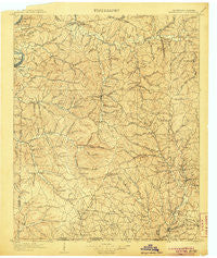
~ Waynesboro TN topo map, 1:125000 scale, 30 X 30 Minute, Historical, 1905
Waynesboro, Tennessee, USGS topographic map dated 1905.
Includes geographic coordinates (latitude and longitude). This topographic map is suitable for hiking, camping, and exploring, or framing it as a wall map.
Printed on-demand using high resolution imagery, on heavy weight and acid free paper, or alternatively on a variety of synthetic materials.
Topos available on paper, Waterproof, Poly, or Tyvek. Usually shipping rolled, unless combined with other folded maps in one order.
- Product Number: USGS-5339180
- Free digital map download (high-resolution, GeoPDF): Waynesboro, Tennessee (file size: 10 MB)
- Map Size: please refer to the dimensions of the GeoPDF map above
- Weight (paper map): ca. 55 grams
- Map Type: POD USGS Topographic Map
- Map Series: HTMC
- Map Verison: Historical
- Cell ID: 66904
- Scan ID: 153562
- Survey Year: 1903
- Datum: Unstated
- Map Projection: Unstated
- Map published by United States Geological Survey
- Map Language: English
- Scanner Resolution: 600 dpi
- Map Cell Name: Waynesboro
- Grid size: 30 X 30 Minute
- Date on map: 1905
- Map Scale: 1:125000
- Geographical region: Tennessee, United States
Neighboring Maps:
All neighboring USGS topo maps are available for sale online at a variety of scales.
Spatial coverage:
Topo map Waynesboro, Tennessee, covers the geographical area associated the following places:
- Dogwood Heights - Moon (historical) - Chinubee - Lower Holly Creek - Forrest Hills - Sorby (historical) - Lodi - Moccasin - Woodlawn - Highland - Leatherwood - Shawnette - Starkey (historical) - Riverside - Sweetwater - Mooney - Hardwick Subdivision - Valleyview Subdivision - Ashland - Green River (historical) - Martins Mills - Victory (historical) - Clifton Junction - Browntown (historical) - Gower (historical) - Flat Woods - Cypress Inn - Ovilla - Pleasant Valley (historical) - Howard (historical) - Wolf Creek - Lego (historical) - Saint Joseph - Oak Grove - Providence - Mount Hope - Whittens Stand (historical) - Mount Nebo - Carrollville (historical) - Clifton - Rhoades Hill (historical) - Weatherford (historical) - Bird (historical) - Highland - Longview Subdivision - Allens Creek (historical) - Westpoint - Geneva - Strathmore (historical) - McLean (historical) - Fairview - Waynesboro - Holt - Ransom Stand - Corning (historical) - Houston - Sims Ridge - Hardwick (historical) - Wayland Springs - Buffalo Valley - Kitchens - Topsy - Yates (historical) - Pinkney - Bethlehem - Voorhies - Collinwood - Sage (historical) - Iron City - New Haven - Cantrell Subdivision - Upper Holly Creek - Star (historical) - Lutts - Crossroads - Holly Creek - Cromwell Crossroads - Light (historical) - Lovie (historical) - Ruppertown - Stout - Turkey Track - Nancy (historical) - Cyclone (historical) - McGlamery Stand
- Map Area ID: AREA35.535-88-87.5
- Northwest corner Lat/Long code: USGSNW35.5-88
- Northeast corner Lat/Long code: USGSNE35.5-87.5
- Southwest corner Lat/Long code: USGSSW35-88
- Southeast corner Lat/Long code: USGSSE35-87.5
- Northern map edge Latitude: 35.5
- Southern map edge Latitude: 35
- Western map edge Longitude: -88
- Eastern map edge Longitude: -87.5


