
~ Wartburg TN topo map, 1:125000 scale, 30 X 30 Minute, Historical, 1895
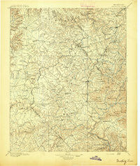
Wartburg, Tennessee, USGS topographic map dated 1895.
Includes geographic coordinates (latitude and longitude). This topographic map is suitable for hiking, camping, and exploring, or framing it as a wall map.
Printed on-demand using high resolution imagery, on heavy weight and acid free paper, or alternatively on a variety of synthetic materials.
Topos available on paper, Waterproof, Poly, or Tyvek. Usually shipping rolled, unless combined with other folded maps in one order.
- Product Number: USGS-5339168
- Free digital map download (high-resolution, GeoPDF): Wartburg, Tennessee (file size: 9 MB)
- Map Size: please refer to the dimensions of the GeoPDF map above
- Weight (paper map): ca. 55 grams
- Map Type: POD USGS Topographic Map
- Map Series: HTMC
- Map Verison: Historical
- Cell ID: 66890
- Scan ID: 153554
- Survey Year: 1893
- Datum: Unstated
- Map Projection: Unstated
- Map published by United States Geological Survey
- Map Language: English
- Scanner Resolution: 600 dpi
- Map Cell Name: Wartburg
- Grid size: 30 X 30 Minute
- Date on map: 1895
- Map Scale: 1:125000
- Geographical region: Tennessee, United States
Neighboring Maps:
All neighboring USGS topo maps are available for sale online at a variety of scales.
Spatial coverage:
Topo map Wartburg, Tennessee, covers the geographical area associated the following places:
- Elgin - Ruppe (historical) - Obed Junction - Cold Springs (historical) - New River - Adkins Mill - Deer Lodge - Holland Ford - Flat Rock - White Oak - Grove - Jamestown - Squirrel Flat - Stockton - Sunbright - Grimsley - East Jamestown - Melrose (historical) - Huffman - Forest Hill (historical) - Burrville - Hughett - Halfway - Piney - Druid Hills - Linger Lake - Allardt - Stowers - Slate Springs - Shady Grove - High Point - Verdun - Shirley - Wiltshire - Gernt - Goad - Liberty - Pine Haven - Midway - Slick Rock - Banner Springs - Oak Hill - Oneida - Toomy - Jonesville - Lavender - Mill Creek - Alpine Acres - Berkshire Forest - Keese (historical) - Zenith - New Haven - Emory (historical) - Mount Helen - Glades - Montgomery (historical) - Catoosa - Woodlands - Wartburg - West Robbins - Glenmary - Cumberland Grove - Peavine - Hebbertsburg - Boiling (historical) - Deermont - Helenwood - Tench - Gobey - Mountain View - Black Creek - Fairfield Glade - Tinch (historical) - Armathwaite - Lancing - Speck - Three Forks - High Point - Catoosa Country - Elizabeth - Nemo - Rugby - Frankfort - Robbins - Howard Mill - Coal Hill - Brewstertown - Black Oak - Pilot Mountain - Catoosa Canyon - Islandford (historical) - Roslin - Genesis - Mill Creek (historical) - Bucklick - Annadel
- Map Area ID: AREA36.536-85-84.5
- Northwest corner Lat/Long code: USGSNW36.5-85
- Northeast corner Lat/Long code: USGSNE36.5-84.5
- Southwest corner Lat/Long code: USGSSW36-85
- Southeast corner Lat/Long code: USGSSE36-84.5
- Northern map edge Latitude: 36.5
- Southern map edge Latitude: 36
- Western map edge Longitude: -85
- Eastern map edge Longitude: -84.5


