
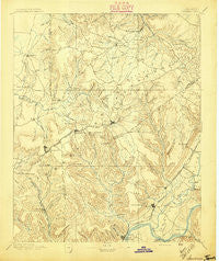
~ Sewanee TN topo map, 1:125000 scale, 30 X 30 Minute, Historical, 1895
Sewanee, Tennessee, USGS topographic map dated 1895.
Includes geographic coordinates (latitude and longitude). This topographic map is suitable for hiking, camping, and exploring, or framing it as a wall map.
Printed on-demand using high resolution imagery, on heavy weight and acid free paper, or alternatively on a variety of synthetic materials.
Topos available on paper, Waterproof, Poly, or Tyvek. Usually shipping rolled, unless combined with other folded maps in one order.
- Product Number: USGS-5339138
- Free digital map download (high-resolution, GeoPDF): Sewanee, Tennessee (file size: 7 MB)
- Map Size: please refer to the dimensions of the GeoPDF map above
- Weight (paper map): ca. 55 grams
- Map Type: POD USGS Topographic Map
- Map Series: HTMC
- Map Verison: Historical
- Cell ID: 66604
- Scan ID: 153543
- Survey Year: 1894
- Datum: Unstated
- Map Projection: Unstated
- Map published by United States Geological Survey
- Map Language: English
- Scanner Resolution: 600 dpi
- Map Cell Name: Sewanee
- Grid size: 30 X 30 Minute
- Date on map: 1895
- Map Scale: 1:125000
- Geographical region: Tennessee, United States
Neighboring Maps:
All neighboring USGS topo maps are available for sale online at a variety of scales.
Spatial coverage:
Topo map Sewanee, Tennessee, covers the geographical area associated the following places:
- Payne Cove - Oak Grove - Wilder Chapel - Roark Cove - Martin Springs - Gruetli - Coalmont - Sweetens Cove - Mountain (historical) - Sequatchie - New Hope - Tarlton - Shady Grove - Pelham - Sherwood - Ladds - Cumberland Heights - Haletown - Prairie Plains - Sewanee - Tatesville - Smithtown - Stephenson - Greentown - Rankin Cove - Hamburg - Mount Olive - Kimball - Bergmantown - Jasper - Purdons (historical) - Pinhook - Summerfield - Whitwell - Beersheba Springs - Ebenezer - Pine Hill - Clifftops - Collins - Orme - Glen - Monteagle - Winton Town - Saint Andrews - Valley Home - Vulcan - Ketchall (historical) - Elkhead - Piedmont - Sartain Springs - Red Hill - Sweeton Hill - Oak Grove - Mount View - Raulstontown - Mineral Springs - Dogtown - The Crossroads - Barkertown - Providence - Saint Marys - Oak Grove - Tracy City - Bells Mill - Laager - Hixon - Hillsboro - Bobtown - Lankford Town - Inman - Altamont - Clouse Hill - Comfort - Dixie Lee - Gruetli-Laager - Hubbards Cove - Flat Branch - Tantallon - Victoria - Ketner Mill - Midway - Ruthledge Hill - Asbury - Rockledge - Glover Hill - Sanders Crossing - Shadrick Hill - Palmer - Alto - Freemont - Nickletown - Hobbs Hill - White City - Betsy Willis - Griffith Creek - Sand Switch - Torbet - East Hill - South Pittsburg
- Map Area ID: AREA35.535-86-85.5
- Northwest corner Lat/Long code: USGSNW35.5-86
- Northeast corner Lat/Long code: USGSNE35.5-85.5
- Southwest corner Lat/Long code: USGSSW35-86
- Southeast corner Lat/Long code: USGSSE35-85.5
- Northern map edge Latitude: 35.5
- Southern map edge Latitude: 35
- Western map edge Longitude: -86
- Eastern map edge Longitude: -85.5


