
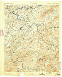
~ Roan Mountain TN topo map, 1:125000 scale, 30 X 30 Minute, Historical, 1891
Roan Mountain, Tennessee, USGS topographic map dated 1891.
Includes geographic coordinates (latitude and longitude). This topographic map is suitable for hiking, camping, and exploring, or framing it as a wall map.
Printed on-demand using high resolution imagery, on heavy weight and acid free paper, or alternatively on a variety of synthetic materials.
Topos available on paper, Waterproof, Poly, or Tyvek. Usually shipping rolled, unless combined with other folded maps in one order.
- Product Number: USGS-5339120
- Free digital map download (high-resolution, GeoPDF): Roan Mountain, Tennessee (file size: 9 MB)
- Map Size: please refer to the dimensions of the GeoPDF map above
- Weight (paper map): ca. 55 grams
- Map Type: POD USGS Topographic Map
- Map Series: HTMC
- Map Verison: Historical
- Cell ID: 66486
- Scan ID: 153533
- Survey Year: 1888
- Datum: Unstated
- Map Projection: Unstated
- Map published by United States Geological Survey
- Map Language: English
- Scanner Resolution: 600 dpi
- Map Cell Name: Room Mountain
- Grid size: 30 X 30 Minute
- Date on map: 1891
- Map Scale: 1:125000
- Geographical region: Tennessee, United States
Neighboring Maps:
All neighboring USGS topo maps are available for sale online at a variety of scales.
Spatial coverage:
Topo map Roan Mountain, Tennessee, covers the geographical area associated the following places:
- Milligan - Blue Spring - S E Miller Subdivision - Watauga Point - Silver Grove - Nanatlugunyi (historical) - Grandview - Bel Air Two - Garland Acres - Tanglewood - Rayon Terrace - Oak Grove - Oakland Village - Kansas City - Buladean - Maison - Tamassee - Hill-N-Dale - Shell Creek - Pigeonroost - Westover - Belmont Acres - Richlands - Whitson - Sumpter (historical) - Huntdale - Greenacres - Upper Poplar - Little Milligan - Upper Shell Creek - Evergreen - Ewart (historical) - East Ridge - Beechwood Court - Cloudland (historical) - Rolling Hills - Honeycutt - Austin Village - Towne Acres - Onks - Cherokee Gardens - Kitzmiller (historical) - Buffalo - Temple Hill - Heaton Creek - McKinley Mobile Home Park - Gap Run - Pine Ridge - Clarketown - Relief - Central - Jonesborough - Big Valley Mobile Home Park - West Oakland Park - Forest Hills - Woodstone - Tunbridge - Shadtown - Charity Hill - Watauga - Herrell (historical) - Siam - Lella (historical) - Limestone Cove - Indian Creek (historical) - Sequoyah Heights - Big Spring - Princeton - Poplar - Green Hill - Royal Pines - Upper Pigeonroost - Pine Timbers - Westwood-Gray Subdivision - Piney Grove - Hawk - Laurel Fork - Brookmead - Sinking Creek - Hickory Lake - Wayfield - Oak Park - Green Pine - Whiteoak Flats - Shenandoah Heights - Brentwood - Ephraim Place - Oak Hill - Strawberry Fields - Okolona - Love Station - Odemville (historical) - Sioux - Hickory Tree - Gap Creek - Buffalo Ridge (historical) - Avondale Forest - Winner - New Bethel - Butler
- Map Area ID: AREA36.536-82.5-82
- Northwest corner Lat/Long code: USGSNW36.5-82.5
- Northeast corner Lat/Long code: USGSNE36.5-82
- Southwest corner Lat/Long code: USGSSW36-82.5
- Southeast corner Lat/Long code: USGSSE36-82
- Northern map edge Latitude: 36.5
- Southern map edge Latitude: 36
- Western map edge Longitude: -82.5
- Eastern map edge Longitude: -82


