
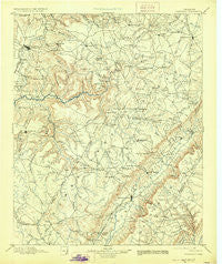
~ Pikeville TN topo map, 1:125000 scale, 30 X 30 Minute, Historical, 1895, updated 1928
Pikeville, Tennessee, USGS topographic map dated 1895.
Includes geographic coordinates (latitude and longitude). This topographic map is suitable for hiking, camping, and exploring, or framing it as a wall map.
Printed on-demand using high resolution imagery, on heavy weight and acid free paper, or alternatively on a variety of synthetic materials.
Topos available on paper, Waterproof, Poly, or Tyvek. Usually shipping rolled, unless combined with other folded maps in one order.
- Product Number: USGS-5339114
- Free digital map download (high-resolution, GeoPDF): Pikeville, Tennessee (file size: 7 MB)
- Map Size: please refer to the dimensions of the GeoPDF map above
- Weight (paper map): ca. 55 grams
- Map Type: POD USGS Topographic Map
- Map Series: HTMC
- Map Verison: Historical
- Cell ID: 66330
- Scan ID: 153486
- Imprint Year: 1928
- Survey Year: 1890
- Datum: Unstated
- Map Projection: Polyconic
- Map published by United States Geological Survey
- Map Language: English
- Scanner Resolution: 600 dpi
- Map Cell Name: Pikeville
- Grid size: 30 X 30 Minute
- Date on map: 1895
- Map Scale: 1:125000
- Geographical region: Tennessee, United States
Neighboring Maps:
All neighboring USGS topo maps are available for sale online at a variety of scales.
Spatial coverage:
Topo map Pikeville, Tennessee, covers the geographical area associated the following places:
- New Harmony - Burgesstown (historical) - Foxfire - Hitchcox - Hiawatha Subdivision - Newton - Saratoga Springs - Ojibwa Subdivision - Shiloh - Heritage Estates - Burke - Hale - Lynwood Acres - Livesay - Harrison Addition - Brockdell - Ninemile - Spencer - Cranmore Cove - Cooper Mill - Meadowview - Lusk - Greenwood - Rainy (historical) - Parkway Estates - Clifty - Mobra - Ogden - Cumberland Spring - Hillcrest - Pinedale - Herbert Domain - Winnebago Subdivision - Midway - Oneida Subdivision - Wild Plum - Sweetgum - Oaklyn - Pine Creek - Lake Park - West End - Taylors Chapel - Phiferes - Sparta Hills - Timberland Estates - Mount Gilead (historical) - Thomas Springs - Methodist (historical) - Meade (historical) - Oak Hill - Sparta Heights - Lantana - Dill - Lanatana Estates - Pomona - River Hill - Dixieland - Nicholson Heights - Smith Chapel - Brookhaven - Morgantown - Summer City - Erasmus - Legget (historical) - Yankeetown - Sparta - Greenbriar Village - Town Branch Estates - Luminary - Dunrovin Estates - Simpsons - Parkview - Bon Air - Vandever - Shangrala - Cane Creek - Cummingsville - Rolling Hills - Camelot - Hilltop Acres - Mooneyham - Volunteer Heights - Port Haven - Pine Grove - Melvine - Lake Tansi Village - Todd Town - Phillps Subdivision - North Dayton - Gillentine (historical) - Lake Tansi - Hickory Hills - Perilla (historical) - Obed River Estates - Middle Brook Place - Jan Mor Acres - Seals (historical) - Stringtown - Hale Mill - Maplewood Estates
- Map Area ID: AREA3635.5-85.5-85
- Northwest corner Lat/Long code: USGSNW36-85.5
- Northeast corner Lat/Long code: USGSNE36-85
- Southwest corner Lat/Long code: USGSSW35.5-85.5
- Southeast corner Lat/Long code: USGSSE35.5-85
- Northern map edge Latitude: 36
- Southern map edge Latitude: 35.5
- Western map edge Longitude: -85.5
- Eastern map edge Longitude: -85


