
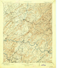
~ Murphy TN topo map, 1:125000 scale, 30 X 30 Minute, Historical, 1914, updated 1927
Murphy, Tennessee, USGS topographic map dated 1914.
Includes geographic coordinates (latitude and longitude). This topographic map is suitable for hiking, camping, and exploring, or framing it as a wall map.
Printed on-demand using high resolution imagery, on heavy weight and acid free paper, or alternatively on a variety of synthetic materials.
Topos available on paper, Waterproof, Poly, or Tyvek. Usually shipping rolled, unless combined with other folded maps in one order.
- Product Number: USGS-5339098
- Free digital map download (high-resolution, GeoPDF): Murphy, Tennessee (file size: 9 MB)
- Map Size: please refer to the dimensions of the GeoPDF map above
- Weight (paper map): ca. 55 grams
- Map Type: POD USGS Topographic Map
- Map Series: HTMC
- Map Verison: Historical
- Cell ID: 66149
- Scan ID: 153478
- Imprint Year: 1927
- Survey Year: 1892
- Datum: NAD
- Map Projection: Polyconic
- Map published by United States Geological Survey
- Map Language: English
- Scanner Resolution: 600 dpi
- Map Cell Name: Murphy
- Grid size: 30 X 30 Minute
- Date on map: 1914
- Map Scale: 1:125000
- Geographical region: Tennessee, United States
Neighboring Maps:
All neighboring USGS topo maps are available for sale online at a variety of scales.
Spatial coverage:
Topo map Murphy, Tennessee, covers the geographical area associated the following places:
- Unaka - McGeetown - McHarg - Postelle - Ironsburg - Burger Town - McAllister Hill - Servilla - Jalapa - Holly Springs - Mecca - Grandview - Ebenezer - Bates Creek - Acorn - Arden - Chestnut Valley - Vests - Kimsey - Towee Falls (historical) - Tariffville - Belltown Mill - Regal - Probst - Bullet Creek - Old Englewood - Nonaburg - Macedonia - Manila - Texana - Mount Harmony - Ducktown - Sandy Lane - Oak Park - Hiwassee Village - Wehutty - Letitia - Ellis Mill - Jeffrey (historical) - Waucheesi - Pleasant Hill - Burger - Stakely Mill - Rymers (historical) - Towee - Boonville (historical) - Pine Ridge - Ogreeta - Postell - Chanceytown - Chestuee - Ballplay - Rafter - Tevis - Farner - Boiling Springs - Gudger - Harbuck - Englewood - Sink (historical) - Maggies Mill - Apalachia - Mount Vernon - Citico (historical) - McFarland - Smithfield - Wolf Creek - Notchy Creek - Cataska - Jacktown - Johnsonville - Ho (historical) - Turtletown - Conasauga - Rural Vale - Reliance - Hothouse - Coletown - Hiwassee - Liberty - Tellico Beach - Tellico Plains - Citico - Big Creek - Belltown Hill - Liberty Hill - Sunny Point - Bethlehem - Isabella - Stewardtown (historical) - Ebenezer - Martins Creek - Grassy Creek - Coker Creek - Murphy - Pleasant Valley - Belltown - Epperson - Conasauga Mill - Reesetown
- Map Area ID: AREA35.535-84.5-84
- Northwest corner Lat/Long code: USGSNW35.5-84.5
- Northeast corner Lat/Long code: USGSNE35.5-84
- Southwest corner Lat/Long code: USGSSW35-84.5
- Southeast corner Lat/Long code: USGSSE35-84
- Northern map edge Latitude: 35.5
- Southern map edge Latitude: 35
- Western map edge Longitude: -84.5
- Eastern map edge Longitude: -84


