
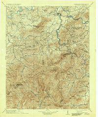
~ Mt Guyot TN topo map, 1:125000 scale, 30 X 30 Minute, Historical, 1912, updated 1937
Mt Guyot, Tennessee, USGS topographic map dated 1912.
Includes geographic coordinates (latitude and longitude). This topographic map is suitable for hiking, camping, and exploring, or framing it as a wall map.
Printed on-demand using high resolution imagery, on heavy weight and acid free paper, or alternatively on a variety of synthetic materials.
Topos available on paper, Waterproof, Poly, or Tyvek. Usually shipping rolled, unless combined with other folded maps in one order.
- Product Number: USGS-5339080
- Free digital map download (high-resolution, GeoPDF): Mt Guyot, Tennessee (file size: 11 MB)
- Map Size: please refer to the dimensions of the GeoPDF map above
- Weight (paper map): ca. 55 grams
- Map Type: POD USGS Topographic Map
- Map Series: HTMC
- Map Verison: Historical
- Cell ID: 320662
- Scan ID: 150161
- Imprint Year: 1937
- Survey Year: 1891
- Datum: Unstated
- Map Projection: Polyconic
- Map published by United States Geological Survey
- Map Language: English
- Scanner Resolution: 600 dpi
- Map Cell Name: Mount Guyot
- Grid size: 30 X 30 Minute
- Date on map: 1912
- Map Scale: 1:125000
- Geographical region: Tennessee, United States
Neighboring Maps:
All neighboring USGS topo maps are available for sale online at a variety of scales.
Spatial coverage:
Topo map Mt Guyot, Tennessee, covers the geographical area associated the following places:
- Shelton Laurel - London - Denton - Naillon (historical) - Dellwood - Midway - Wilton Springs - Catons Grove - West Myers - Cove Creek - Bridgeport - Chestnut Hill - Laurel - Click Mill - Nellie - Douglas Estates - Greenbrier (historical) - Walnut Grove - Mount Sterling - Tryon - Allen Grove - Jaybird - Newport - East Fork - Cartertown - Fort Harry - Clevenger - Shady Grove - Three Forks - West End - Bird Crossroad - Crestmont - Edwina - Cataloochee - Ravensford - Promised Land - Oldtown - Wilsonville - Harrisburg - Pittman Center - Fox (historical) - Birdsville (historical) - Richardson Cove - Cosby - Hartford - Texas Settlement (historical) - Eastport - Zion Grove - Pinnacle - Finney Patch - Glade - Bailey Town - Read Hill - Pleasant Grove - Grassy Fork - Maple Spring - Bryson Place - Forest Hill - Reidtown - Caton - Seaton Spring - Long Creek - Maggie Valley - Baltimore - Bat Harbor - Jimtown - Jones Cove - Nough - Irish Cut - Cedar Bluff - Carson Springs - English Creek - Allensville (historical) - Sunset Gap - Northport - Sandy Ridge - Naillontown (historical) - Padgett Mill - Bluffton - Waterville - Licklog - Shady Grove - Raven Branch - Suttontown - Rocky Grove - Jenkins Mill - Gum Spring - Del Rio - Castle Heights - Pleasant Hill (historical) - Oldham - Fair Garden - Tom Town - Schroder (historical) - Crockettsville - Jonathan - Edgemont - Ola - Browns
- Map Area ID: AREA3635.5-83.5-83
- Northwest corner Lat/Long code: USGSNW36-83.5
- Northeast corner Lat/Long code: USGSNE36-83
- Southwest corner Lat/Long code: USGSSW35.5-83.5
- Southeast corner Lat/Long code: USGSSE35.5-83
- Northern map edge Latitude: 36
- Southern map edge Latitude: 35.5
- Western map edge Longitude: -83.5
- Eastern map edge Longitude: -83


