
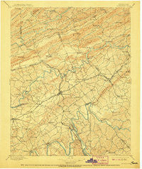
~ Morristown TN topo map, 1:125000 scale, 30 X 30 Minute, Historical, 1895, updated 1907
Morristown, Tennessee, USGS topographic map dated 1895.
Includes geographic coordinates (latitude and longitude). This topographic map is suitable for hiking, camping, and exploring, or framing it as a wall map.
Printed on-demand using high resolution imagery, on heavy weight and acid free paper, or alternatively on a variety of synthetic materials.
Topos available on paper, Waterproof, Poly, or Tyvek. Usually shipping rolled, unless combined with other folded maps in one order.
- Product Number: USGS-5339064
- Free digital map download (high-resolution, GeoPDF): Morristown, Tennessee (file size: 9 MB)
- Map Size: please refer to the dimensions of the GeoPDF map above
- Weight (paper map): ca. 55 grams
- Map Type: POD USGS Topographic Map
- Map Series: HTMC
- Map Verison: Historical
- Cell ID: 66097
- Scan ID: 153461
- Imprint Year: 1907
- Survey Year: 1890
- Datum: Unstated
- Map Projection: Unstated
- Map published by United States Geological Survey
- Map Language: English
- Scanner Resolution: 600 dpi
- Map Cell Name: Morristown
- Grid size: 30 X 30 Minute
- Date on map: 1895
- Map Scale: 1:125000
- Geographical region: Tennessee, United States
Neighboring Maps:
All neighboring USGS topo maps are available for sale online at a variety of scales.
Spatial coverage:
Topo map Morristown, Tennessee, covers the geographical area associated the following places:
- Nenny - Chuckey Bend (historical) - Shiloh - Withers Subdivision - Beechnut Subdivision - Hales Crossroads - Pate Hill - Creek Store - White Horn - Morristown - Wildwood - Silver City - Howard Quarter - Bowen - Tate Springs - Liberty Heights - Riverview - Depew Addition - Ottinger - Briarcliff View - Turley Mills (historical) - Ridgeview - Music Acres - Bulls Gap - Hillcrest - Hunters Ridge - Brockland Acres - Lilac (historical) - Boggs - Roe - Mountain View - Witt Acres - Meadow Branch - Dover - Sugar Forks - East Village - Cedar Hill Park - Oakland - Wa-Ni Village - Britton Acres - Panther Hills - Leadvale - Beech Grove - Rambling Hills - Lakemoore - Big Q Estates - May Acres - Rolling Hills - Beech Grove - Ritchie - Cloud Creek - Gravelly Hill - Salem - Pleasant Hill - Mansfield Gap - Glendale Acres - Skinner Crossroad - Wood Acres - Kentucky Heights - Holly Hills - Xenophon - Fuller Estates - Bruner Grove - North Brook - Indian HIlls - Paradise Pointe - Redwine - Lampkin Acres - Greenhill - Susong - Mount Horeb - Arrow Hills - Point Seven - Wyatt Village - Pineville - Mohawk Crossroad - Coran - Avondale - Mulberry Acres - Crockett Ridge - Rocky Point - Mooresburg Springs - Timbercrest - Holston Hills - Belmont - West Lake Estates - Swann - Brookside Mill - Rogersville - Holttown - Clinchview Heights - Needmore - Rankin - High Point - Friendship - Altonville - Buell Acres - Leadvale - Lowe Acres - Drinnon Heights
- Map Area ID: AREA36.536-83.5-83
- Northwest corner Lat/Long code: USGSNW36.5-83.5
- Northeast corner Lat/Long code: USGSNE36.5-83
- Southwest corner Lat/Long code: USGSSW36-83.5
- Southeast corner Lat/Long code: USGSSE36-83
- Northern map edge Latitude: 36.5
- Southern map edge Latitude: 36
- Western map edge Longitude: -83.5
- Eastern map edge Longitude: -83


