
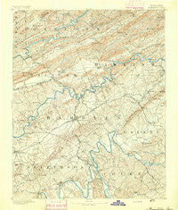
~ Morristown TN topo map, 1:125000 scale, 30 X 30 Minute, Historical, 1893
Morristown, Tennessee, USGS topographic map dated 1893.
Includes geographic coordinates (latitude and longitude). This topographic map is suitable for hiking, camping, and exploring, or framing it as a wall map.
Printed on-demand using high resolution imagery, on heavy weight and acid free paper, or alternatively on a variety of synthetic materials.
Topos available on paper, Waterproof, Poly, or Tyvek. Usually shipping rolled, unless combined with other folded maps in one order.
- Product Number: USGS-5339058
- Free digital map download (high-resolution, GeoPDF): Morristown, Tennessee (file size: 9 MB)
- Map Size: please refer to the dimensions of the GeoPDF map above
- Weight (paper map): ca. 55 grams
- Map Type: POD USGS Topographic Map
- Map Series: HTMC
- Map Verison: Historical
- Cell ID: 66097
- Scan ID: 153458
- Survey Year: 1890
- Datum: Unstated
- Map Projection: Unstated
- Map published by United States Geological Survey
- Map Language: English
- Scanner Resolution: 600 dpi
- Map Cell Name: Morristown
- Grid size: 30 X 30 Minute
- Date on map: 1893
- Map Scale: 1:125000
- Geographical region: Tennessee, United States
Neighboring Maps:
All neighboring USGS topo maps are available for sale online at a variety of scales.
Spatial coverage:
Topo map Morristown, Tennessee, covers the geographical area associated the following places:
- Riverview - West Lake Estates - Morristown - Wa-Ni Village - Keister - Lakemont Cabin Area - Buell Acres - Wolf Acres - Paradise Pointe - Hales Crossroads - Indian HIlls - Pate Hill - Wood Acres - Rocky Point - Rankin - Luther - Sugar Forks - Flat Gap - White Pine Mobile Home Park - Edgewood - Kilgore Subdivision - Rolling Acres - Ritchie - Saint Clair - Oakland - Mooresburg - Beech Grove - Duck Creek - Rambling Hills - Altonville - Bright (historical) - Point Pleasant - Camelot - Holston Hills - Emerald Acres - Lake View Park - Jackson Heights - Westview - Woodcrest Hills - Drinnon Heights - Ottinger - Hunnicutt Mill - Swann - Glendale Acres - High Point - Thula - Choptack - Fernwood Heights - Ridgeview - Beacon Hills - Nenny - Springvale - Henardtown - Brookside Mill - Quail Hollow - Coulter - Grants Chapel - Chuckey Bend (historical) - Westgate - Coran - Austins Mill - Rogersville - Bray - Point Seven - Beaver Dam (historical) - Mount Horeb - Turley Mills (historical) - Russellville - Southern Heights - Xenophon - Oakland - Otes - Hillcrest - Patterson Hills - Sherwood Estates - West Hills - Willow Springs - Lawson Mill - Alumwell - Fox Den - Melody Acres - Panther Lake - Lilac (historical) - Sulphur Springs - Beans - Purkey Estates - Lowe Acres - Oak Grove - Gaby Hills - Kentucky Heights - Stithsville (historical) - Cedar Hills - Kingswood - Silver City - Campbell Acres - Witt Acres - Bird Hill - Crosby - Talbott - Mountain View
- Map Area ID: AREA36.536-83.5-83
- Northwest corner Lat/Long code: USGSNW36.5-83.5
- Northeast corner Lat/Long code: USGSNE36.5-83
- Southwest corner Lat/Long code: USGSSW36-83.5
- Southeast corner Lat/Long code: USGSSE36-83
- Northern map edge Latitude: 36.5
- Southern map edge Latitude: 36
- Western map edge Longitude: -83.5
- Eastern map edge Longitude: -83


