
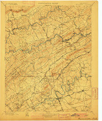
~ Maynardville TN topo map, 1:125000 scale, 30 X 30 Minute, Historical, 1900
Maynardville, Tennessee, USGS topographic map dated 1900.
Includes geographic coordinates (latitude and longitude). This topographic map is suitable for hiking, camping, and exploring, or framing it as a wall map.
Printed on-demand using high resolution imagery, on heavy weight and acid free paper, or alternatively on a variety of synthetic materials.
Topos available on paper, Waterproof, Poly, or Tyvek. Usually shipping rolled, unless combined with other folded maps in one order.
- Product Number: USGS-5339036
- Free digital map download (high-resolution, GeoPDF): Maynardville, Tennessee (file size: 8 MB)
- Map Size: please refer to the dimensions of the GeoPDF map above
- Weight (paper map): ca. 55 grams
- Map Type: POD USGS Topographic Map
- Map Series: HTMC
- Map Verison: Historical
- Cell ID: 66011
- Scan ID: 153523
- Survey Year: 1895
- Datum: Unstated
- Map Projection: Unstated
- Map published by United States Geological Survey
- Map Language: English
- Scanner Resolution: 600 dpi
- Map Cell Name: Maynardville
- Grid size: 30 X 30 Minute
- Date on map: 1900
- Map Scale: 1:125000
- Geographical region: Tennessee, United States
Neighboring Maps:
All neighboring USGS topo maps are available for sale online at a variety of scales.
Spatial coverage:
Topo map Maynardville, Tennessee, covers the geographical area associated the following places:
- John Sevier - Four Points - Cupp Mill - Buffat Heights - Holston Mobile Home Park - Little Barren - Lone Mountain - Preston (historical) - Millertown - Arminda - Lost Creek (historical) - Lucilla (historical) - Wooddale - Williams Springs - Halls And Powell Mobile Home Park - Sunrise - Carter - Old Cedar Fork - Rhodelia (historical) - Powells River (historical) - Corryton - Mynatt - McMillan - New Tazewell - Sharps Chapel - Lyonton - Tazewell - North Knoxville - Hinds Creek Valley - Liberty Hill - Haynes (historical) - Harbison Crossroads - House Mountain (historical) - Deer Ridge Mobile Home Court - Dry Gap - Stockville (historical) - Plantation Acres Mobile Home Park - Northbrook - Cedar Grove - Whispering Hills - Graveston - Lulaville - Clouds - Haversons (historical) - Briarwood Estates - Raccoon Valley - Fieldview - Sumter Hills - Richland - Joppa - Sentertown - Mascot - Ailor (historical) - Highlands (historical) - White Hollow - Beverly Acres - Springdale - Hurricane Branch (historical) - Eastwood - Emory Estates - Rutledge - Piedmont - Hickory - Twinville - Massengill Mill - Chestnut Ridge - Tillery Drive Mobile Home Park - Sycamore Spring - Hallbrook - Oak Park - Paulette - Chesney - Happy Acres - Bonta Vista Estates - Sycamore (historical) - Saddle Ridge - Black Oak - Skaggston - Maynardville - Mill Run - Mossy Spring - Ritta - Condon - Fountaincrest - Beeler Mill - Beulah - Pinewood Trailer Park - Flat Hollow - Chestnut Grove - New Market - Chittum - Nances Grove - Chilhowee Hills - Spring Place - Goin - Carpenter Addition - Northridge Estates - Trentville - Pleasant Grove - Fountain City
- Map Area ID: AREA36.536-84-83.5
- Northwest corner Lat/Long code: USGSNW36.5-84
- Northeast corner Lat/Long code: USGSNE36.5-83.5
- Southwest corner Lat/Long code: USGSSW36-84
- Southeast corner Lat/Long code: USGSSE36-83.5
- Northern map edge Latitude: 36.5
- Southern map edge Latitude: 36
- Western map edge Longitude: -84
- Eastern map edge Longitude: -83.5


